Atlanta, Charlotte and the Carolinas Face a Cool and Dry Start to June as Cold Air Pushes South Through the First Week
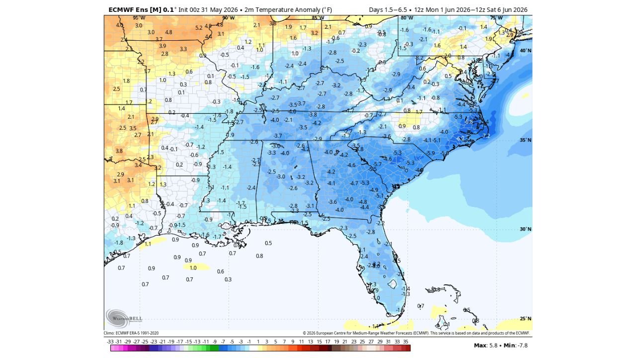
ATLANTA, GA — June is arriving with a cold shoulder across the Southeast United States. Temperature anomaly data valid from Monday, June 1 through Saturday, June 6, 2026 shows a broad pool of below-normal temperatures draped across the entire Southeast, driven not by rain and storm activity but by a surge of cool, dry air pushing southward from the north. This is a genuine early June cool-down for millions of residents from Tennessee through Georgia, the Carolinas, and into Florida.
Cool Dry Air From the North Is Driving This Pattern
Unlike last week’s cool periods which were associated with storm activity, this early June cold shot is driven entirely by cool dry air advecting southward from the north. A coastal spin off the Southeast Atlantic Coast could actually enhance the southward pull of this dry air mass, reinforcing the below-normal temperature pattern through the first week of June.
The result is a dry, comfortable, and noticeably cool start to meteorological summer for the Southeast, a region that is typically already deep into heat and humidity by early June.
How Far Below Normal Temperatures Will Run
Current ensemble temperature anomaly data shows the deepest cold anomalies concentrated across North Carolina, South Carolina, Virginia, and coastal Georgia, where departures of 4 to 7 degrees below normal are shown. The Carolinas coast is running the coldest on the map with anomalies reaching 5 to 7 degrees below the historical average for early June.
Atlanta and central Georgia sit at 3 to 4 degrees below normal. Tennessee and Alabama are running 2 to 4 degrees below normal. Even northern Florida shows anomalies of 2 to 3 degrees below normal despite being the southernmost portion of the cold pool.
Temperature Anomaly by City
| City | Anomaly | Early June Feel |
|---|---|---|
| Charlotte, NC | 5 to 7°F below normal | Noticeably cool and dry |
| Raleigh, NC | 4 to 6°F below normal | Cool with low humidity |
| Atlanta, GA | 3 to 4°F below normal | Comfortable, below average |
| Nashville, TN | 2 to 3°F below normal | Mild start to June |
| Birmingham, AL | 2 to 4°F below normal | Below normal temperatures |
| Jacksonville, FL | 2 to 3°F below normal | Cooler than typical early June |
What This Means for the First Week of June
Residents across the Southeast can expect morning lows in the 50s to low 60s Fahrenheit across Tennessee, North Carolina, and South Carolina through the first week of June, with afternoon highs staying in the 70s rather than the upper 80s and 90s that typically characterize early June across this region. The dry air component means humidity will remain low, making the cool temperatures feel even more comfortable than the numbers suggest.
This is not severe weather. This is simply a very pleasant and atypical start to June for the Southeast.
Confidence in below-normal temperatures across the Southeast through the first week of June is HIGH. Confidence in the coastal spin enhancing the dry air pull southward is MODERATE.
More weather coverage is always on the horizon. Stay informed at ChicagoMusicGuide.com — your source for seasonal pattern analysis and breaking weather coverage across the Southeast and the entire United States.