Central United States Faces an Active and Wetter Than Normal June as Humidity Rebuilds and Storm Pattern Returns Through Mid-Month
KANSAS CITY, MO — The first two weeks of June are shaping up to be increasingly active across the central United States, with current long-range precipitation data and official outlook products pointing toward above-normal rainfall across a broad corridor from Texas through the Plains, Midwest, and Southeast. After a brief drier stretch across the East this week, the pattern gets progressively wetter and more storm-prone as June advances.
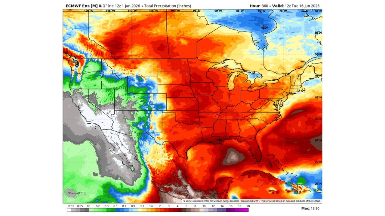
15-Day Precipitation Totals Paint a Dry East and Wet Center
Total precipitation forecast data valid through June 16, 2026 shows a striking contrast across the country. The deep red and orange coloring dominating the central and eastern United States on the 15-day accumulation map indicates below-normal to well-below-normal precipitation for the Great Lakes, Ohio Valley, Northeast, and mid-Atlantic through this period. Meanwhile the southern Plains, Gulf Coast, and central Rockies are shown in greens and blues indicating meaningful precipitation accumulation.
The key signal is the warm temperature pattern across the central United States, which current analysis indicates will drive humidity back into the region and set the stage for an increasingly active storm pattern as the month progresses.
June 7 Through 11 Outlook Favors Above Normal Rain Across the Plains and South
The official 6 to 10 Day Precipitation Outlook valid June 7 through 11 shows above-normal precipitation probability covering the entire central United States from Texas northward through Kansas, Missouri, Arkansas, Tennessee, and into the Southeast. The 40 to 60% probability of above-normal rainfall across this corridor indicates meaningful confidence in a wetter than average period for these states during the second week of June.
Nevada and portions of the Great Basin are the only areas flagged for below-normal precipitation during this window. The Northeast and New England sit in the near-normal zone.
June 9 Through 15 Keeps the Active Pattern Going
The 8 to 14 Day Precipitation Outlook valid June 9 through 15 maintains the above-normal signal across Texas and the Gulf Coast while expanding the wetter than normal signal into Virginia, North Carolina, South Carolina, and the broader mid-Atlantic Southeast corridor. The northern Plains and upper Midwest pick up an above-normal signal as well during this window.
California and the Great Basin remain flagged for below-normal precipitation through the extended period.
Precipitation Outlook Summary
| Period | Wettest Zone | Key States | Signal Strength |
|---|---|---|---|
| Through June 16 | Central US and Gulf Coast | TX, OK, KS, MO, AR | Active storm pattern building |
| June 7 to 11 | Central Plains and Southeast | TX, KS, MO, TN, AR | 40 to 60% above normal |
| June 9 to 15 | Gulf Coast and mid-Atlantic South | TX, VA, NC, SC, FL | Above normal expanding east |
| Entire period | Below normal | Nevada, Great Basin, Northeast | Drier than average |
Humidity Rebuilding Is the Key Signal
Current temperature pattern data shows above-normal temperatures across the central United States, a direct indicator that Gulf moisture will be pulling northward and rebuilding humidity across Texas, Oklahoma, Kansas, Missouri, and the Midwest through the first half of June. When above-normal warmth and increasing moisture combine across the Plains in June, the result is an environment increasingly favorable for organized thunderstorm development, heavy rainfall, and the potential for severe weather during peak heating hours.
Forecast Confidence
Confidence in an active and wetter than normal pattern across the central United States from June 7 through June 15 is MODERATE to HIGH based on the consistency of both the long-range model data and the official outlook products. Confidence in specific storm events, timing, and severe weather potential within this window is LOW to MODERATE at this range and will sharpen through the week.
Residents across Texas, Oklahoma, Kansas, Missouri, Arkansas, and the Southeast should expect June to bring regular rounds of rain and thunderstorms as the humidity-driven active pattern becomes established.
More weather coverage is always on the horizon. Stay informed at ChicagoMusicGuide.com — your source for extended precipitation outlooks, pattern analysis, and breaking weather coverage across the Plains, Southeast, and the entire United States.