Heavy Mountain Snow and Lowland Mix Expected Across Washington as Major Winter System Moves In
WASHINGTON STATE — A major winter system is moving into Washington beginning Tuesday morning, bringing heavy mountain snow and lowland rain/snow mix through midweek. Meteorologists warn that travelers crossing the Cascade passes should prepare for hazardous driving conditions as snow levels fluctuate and accumulation builds rapidly.
According to forecasts, snow levels will start near 1,500 feet Tuesday, rising to about 3,000 feet by evening and up to 5,000 feet late Wednesday. The lower snow levels early in the system will bring moderate to heavy snow to mountain areas and slushy conditions in some eastern valleys before a gradual warm-up transitions precipitation to rain.
Snowfall Projections Across the State
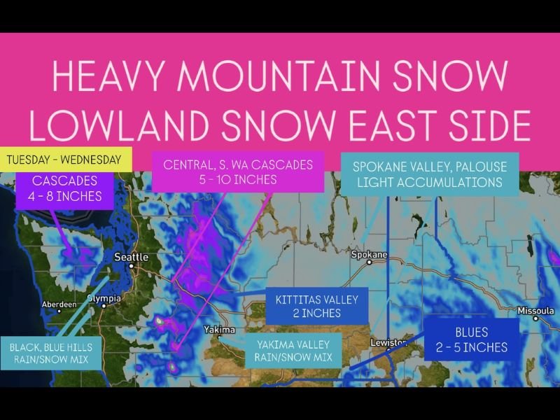
The Washington Cascades are expected to receive 4–10 inches of snow, with the central and southern ranges seeing the heaviest accumulation.
- Cascades: 4–8 inches of snow expected
- Central & Southern WA Cascades: 5–10 inches
- Blues (southeast WA): 2–5 inches
- Kittitas Valley: Around 2 inches
- Yakima Valley: Rain/snow mix
- Spokane Valley & Palouse: Light accumulations
Travel Impacts and Safety Concerns
Officials are advising drivers crossing Snoqualmie, Stevens, and White Passes to check real-time road reports and adhere to traction tire or chain requirements.
“Travelers should be prepared for sudden changes in visibility and slick pavement,” forecasters cautioned, adding that heavy snow will make travel difficult at times Tuesday and Wednesday.
Residents in Pullman, Spokane, and Yakima could also see brief lowland snow before warmer air changes precipitation to rain later in the day. Even hills on the west side, including parts of the Black and Blue Hills, could experience a short-lived rain/snow mix early Tuesday.
Meteorologists Warn of Rapid Shifts
As the snow level rises through Wednesday, conditions will shift quickly from snow to freezing rain or slush, creating treacherous passes and melting runoff. Motorists are urged to avoid nonessential mountain travel until the storm passes and roads are cleared.
The National Weather Service recommends monitoring local advisories and checking Washington State DOT updates before traveling through the mountains.
Stay weather-aware and follow chicagomusicguide.com for continued updates on regional storm systems and national weather alerts.