Heavy Snowstorm Expected Across New York and Connecticut Dec. 26–27, With 6–10 Inches Possible and Mixing Zones Adding Uncertainty
CONNECTICUT — A significant winter storm is increasingly likely to impact large portions of the Northeast from Friday, December 26 through Saturday, December 27, with forecast models showing moderate to heavy snowfall across upstate New York and much of Connecticut, while areas farther south and west face a more complex mix of snow, sleet, and freezing rain.
Forecasters stress that this is not yet a final snowfall map, but confidence is growing that a widespread winter weather event will unfold as colder air locks in across the region and moisture surges northward late Friday.
What Forecast Models Are Showing Right Now
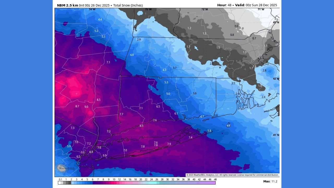
Based on the latest National Blend of Models (NBM) guidance and early snowfall projections, the highest confidence for impactful snow currently centers on central and eastern New York and Connecticut.
Current snowfall ranges indicated by the data include:
- Central New York (Syracuse, Binghamton region):
6 to 8 inches, with localized totals of 8 to 12 inches possible in stronger snow bands. - Upstate New York into the Capital Region (Albany area):
4 to 6 inches, tapering northward. - Southwest Connecticut:
6 to 10 inches, with isolated totals near 11 inches possible west of Route 8. - Rest of Connecticut:
2 to 6 inches, depending on storm track and late-stage mixing. - Northern Pennsylvania into western New York:
Lower totals overall, with 1 to 4 inches, and a higher risk of sleet or freezing rain instead of pure snow.
Meteorologists note that snow ratios may be high, meaning lighter, fluffier snow could accumulate quickly during the initial burst of precipitation Friday night.
Mixing Zone Adds Forecast Uncertainty
One of the biggest challenges with this storm is the transition zone where snow may change to sleet or freezing drizzle before ending. Forecast maps clearly show a corridor of uncertainty stretching from northern Pennsylvania through parts of southern New York and into coastal southern New England.
In these areas:
- Snow may start strong before mixing with sleet or freezing rain late
- Ice accumulation, while uncertain, could still create hazardous travel conditions
- Small shifts in temperature profiles could dramatically alter final totals
Forecasters expect Friday morning observations to play a key role in refining snowfall amounts and precipitation type.
Timing: When Impacts Are Most Likely
- Friday afternoon: Precipitation begins developing across the Mid-Atlantic and southern New York
- Friday evening into overnight: Heaviest snowfall rates likely across New York and Connecticut
- Early Saturday: Snow tapers west to east, with lingering mixing possible near the coast
Travel conditions are expected to deteriorate rapidly Friday night, especially along major corridors in New York and Connecticut.
Why This Forecast Could Still Change
Meteorologists caution that this is an early projection, not a final call. The storm’s exact track, strength of cold air, and timing of the warm layer aloft will determine:
- How far south heavy snow extends
- Whether mixing zones shift north or south
- Which communities see the highest totals
As noted by forecasters, this is a situation where learning from upstream observations will be critical, and snowfall maps may be adjusted upward or downward as new data arrives.
What Residents Should Do Now
- Stay updated on local forecasts heading into Friday
- Prepare for snow-covered roads and reduced visibility
- Allow extra travel time Friday night and early Saturday
- Monitor advisories or warnings that may be issued as confidence increases
This storm has the potential to be one of the more impactful winter weather events of the season so far for parts of New York and Connecticut, especially if higher-end snowfall projections verify.
For continuing weather updates, forecast breakdowns, and regional impact coverage, follow Chicagomusicguide.com as new information becomes available.