Great Lakes and Upper Midwest Face Rare Hurricane-Force Wind Threat as Powerful Non-Tropical Storm Targets Region Monday
GREAT LAKES REGION — A powerful and unusually intense storm system is drawing growing concern across the Great Lakes, Upper Midwest, and parts of the Appalachians as meteorologists warn that hurricane-force wind gusts may develop Monday, a rare signal for a non-tropical weather system.
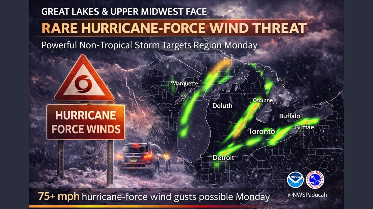
According to advanced ensemble modeling, the storm could produce wind gusts exceeding 75 mph, a threshold more commonly associated with hurricanes than winter or mid-latitude systems. Forecasters say the developing setup poses a high-end wind event capable of causing widespread power outages, infrastructure damage, and dangerous travel conditions across multiple states.
Rare ECMWF Signal Raises Alarm for Extreme Winds
Meteorologists are closely monitoring data from the ECMWF-EPS ensemble, a forecasting tool most often used to analyze hurricane behavior. The model is currently signaling a notable probability of wind gusts surpassing 75 mph, an uncommon and concerning indicator for a non-tropical storm.
Forecasters emphasize that this type of signal is rare outside of tropical cyclones, underscoring the unusual intensity expected from this system as it moves through the region on Monday.
Areas Most at Risk for Hurricane-Force Gusts
The highest risk for extreme winds includes several densely populated and weather-sensitive regions:
- The Great Lakes, where wind acceleration over open water may enhance gust strength
- Western and Upstate New York, particularly in and around Buffalo
- The Appalachian spine, including the West Virginia and Maryland panhandles
- Southwestern Pennsylvania, where terrain may further intensify wind impacts
Forecast graphics indicate long, narrow corridors of enhanced wind potential stretching from the Upper Midwest through the Great Lakes and into the Northeast.
Potential Impacts: Power Outages, Structural Damage, Travel Disruptions
If hurricane-force gusts materialize, impacts could be significant:
- Downed trees and power lines, especially in areas with saturated or frozen ground
- Widespread power outages, potentially lasting multiple days
- Structural damage to roofs, signage, and weaker buildings
- Hazardous travel, particularly for high-profile vehicles and along exposed roadways
Officials urge residents to prepare for rapidly changing conditions and to secure loose outdoor objects ahead of the storm’s arrival.
Timing and What to Watch Next
Forecast data highlights Monday as the primary window for peak wind impacts, though conditions could deteriorate quickly as the system strengthens. Meteorologists stress that small shifts in the storm’s track could significantly change where the strongest winds ultimately occur.
Because this is a non-tropical system producing hurricane-level wind potential, forecasters are advising heightened awareness even in areas accustomed to winter weather.
Stay Alert as Forecasts Continue to Evolve
Weather officials continue to analyze updated model runs and observational data as the storm approaches. Residents across the Great Lakes and surrounding regions are urged to monitor local forecasts closely, follow official alerts, and be prepared to adjust plans if conditions worsen.
ChicagoMusicGuide.com will continue tracking this developing storm and provide updates as new information becomes available.