Missouri Sees Historic 55-Degree Temperature Collapse as Polar Vortex–Fueled Bomb Cyclone Rips Through the Central United States
MISSOURI — A violent polar vortex–fueled bomb cyclone triggered an extraordinary temperature collapse of up to 55 degrees Fahrenheit across Missouri, marking one of the most extreme 24-hour temperature swings seen this winter. Newly analyzed temperature-change data shows the cold front racing southeast through the Central Plains, Midwest, and Lower Mississippi Valley, replacing mild air with deep Arctic cold in a matter of hours.
The data confirms that Missouri sat near the epicenter of the cold surge, with surrounding states experiencing similarly dramatic but slightly lesser drops as the system intensified.
Missouri Ground Zero for the Temperature Collapse
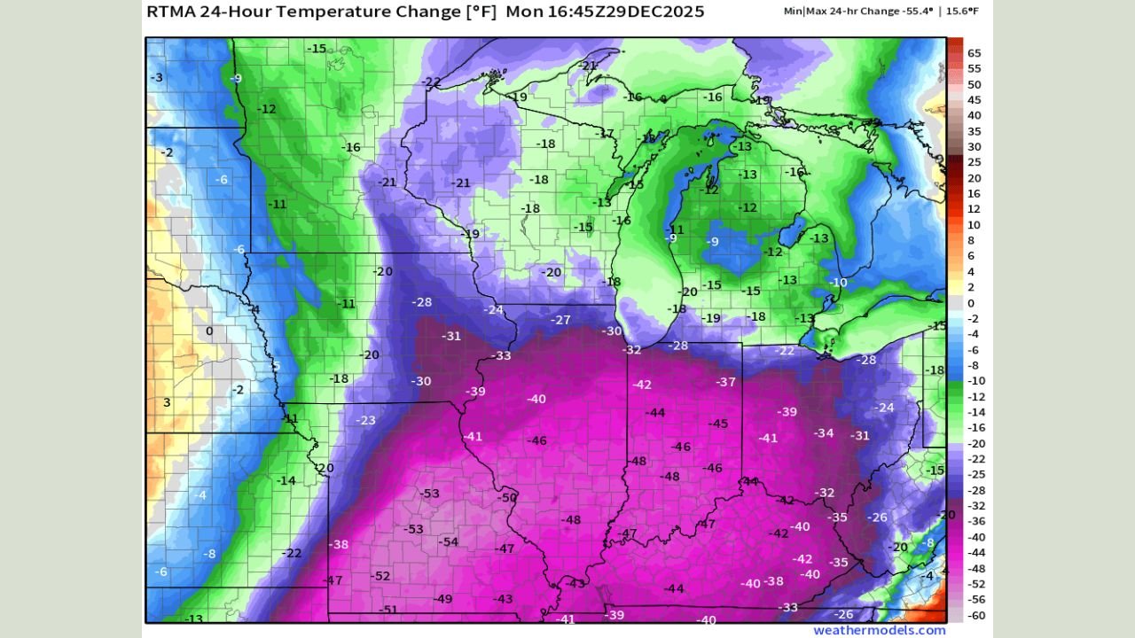
Temperature-change maps clearly place Missouri in the heart of the most intense cooling, with widespread drops between 45 and 55 degrees compared to readings just 24 hours earlier. Central and southern Missouri recorded the steepest falls as the Arctic front surged through behind the rapidly strengthening storm system.
This kind of temperature collapse is rare even by mid-winter standards and is characteristic of bomb cyclones, where surface pressure falls rapidly and strengthens the cold front’s forward momentum.
Central U.S. Widespread Drops of 30–50 Degrees
While Missouri experienced the most extreme numbers, the broader central United States was also heavily impacted. Large portions of Kansas, Illinois, Iowa, Arkansas, Tennessee, Kentucky, and Mississippi saw 30- to 50-degree temperature drops in less than a day.
The sharp gradient visible on the maps shows how aggressively the Arctic air displaced the pre-existing warmth, creating a narrow but powerful transition zone that raced eastward.
Bomb Cyclone and Polar Vortex Interaction Drove the Extreme Cold
This event was intensified by a bomb cyclone interacting with the polar vortex, a combination that dramatically amplifies cold air transport. As the storm rapidly strengthened, it pulled Arctic air southward at high speed, allowing temperatures to free-fall behind the front.
The data suggests this was not a slow cooling trend, but a sudden atmospheric flip, where locations went from relatively mild conditions to mid-winter cold in just a few hours.
Why These Arctic Fronts Are Becoming More Intense
The accompanying analysis highlights a concerning trend: Arctic cold fronts are arriving with greater intensity as the jet stream becomes more volatile. Stronger temperature contrasts between air masses can lead to faster-moving, more extreme frontal passages, increasing the likelihood of abrupt and disruptive cold outbreaks.
This pattern supports the idea that winter weather events are becoming less gradual and more abrupt, raising challenges for travel, infrastructure, and daily planning.
Impacts Beyond the Thermometer
Rapid temperature collapses of this magnitude can have serious downstream effects, including:
- Flash freezing on roadways
- Strain on power and heating systems
- Increased risk of burst pipes
- Dangerous wind chills following the front
In Missouri and neighboring states, the sudden nature of the cold surge made conditions especially hazardous, as communities had little time to adjust.
What Happens Next
Although temperatures will eventually stabilize, the data shows the Arctic air mass firmly entrenched across the Midwest and Lower Mississippi Valley in the near term. Additional reinforcing shots of cold remain possible as the broader winter pattern stays active.
As extreme weather continues to affect travel, touring, and regional movement across the country, ChicagoMusicGuide.com will keep tracking how powerful cold outbreaks like this one impact the Central United States and beyond.