Oswego County Braces for Dangerous Lake-Effect Snowstorm as Intense Bands Bring Major Travel Disruptions Through Friday
OSWEGO COUNTY, NEW YORK — A dangerous lake-effect snow event is intensifying across Oswego County as well-organized snow bands redevelop tonight and persist through Friday, bringing the potential for extremely heavy snowfall rates and major travel impacts. Forecast data from the National Weather Service in Buffalo shows the most intense snow focusing over Oswego County for prolonged periods, especially along and south of Lake Ontario.
Meteorologists warn that snowfall rates within the strongest bands could become severe enough to quickly overwhelm road crews, making travel hazardous or nearly impossible at times.
Intense Lake-Effect Snow Bands Focus on Oswego County
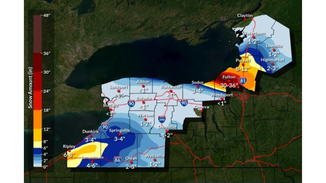
The most concerning aspect of this forecast is the persistent and highly concentrated lake-effect snow band expected to repeatedly target Oswego County, including areas such as Oswego, Fulton, Pulaski, and surrounding communities. Forecast maps indicate snowfall totals increasing rapidly where the band stalls, with localized totals significantly higher than surrounding areas.
This event is being driven by cold Arctic air moving over the warmer waters of Lake Ontario, allowing snow bands to strengthen and become more organized overnight and into Friday morning.
Extreme Snowfall Rates Could Reach 3 to 5 Inches Per Hour
According to forecast guidance, snowfall rates in the most intense portion of the lake-effect band may increase to 3 to 5 inches per hour, particularly during peak overnight and early morning periods. At these rates, whiteout conditions can develop rapidly, with visibility dropping to near zero.
Such intense snowfall can quickly bury roads, making plowing difficult and causing sudden travel shutdowns, especially on secondary roads and rural routes.
Major Travel Impacts Expected Across Oswego County
Officials warn that major travel impacts are likely across Oswego County, especially during times when the snow band becomes stationary. Interstate corridors, state highways, and local roads could experience rapidly deteriorating conditions, including snow-covered pavement and drifting snow.
Drivers attempting to travel during the height of the storm may encounter unexpected road closures, stranded vehicles, and emergency response delays. Even short trips could become dangerous when snowfall rates spike.
Snow Impacts Also Extend to Neighboring Counties
While Oswego County remains the primary target, surrounding areas in far northern Cayuga County and portions of central New York may also see periods of heavy snow, though impacts are expected to be less intense and more intermittent compared to Oswego County.
Farther west, lake-effect snow off Lake Erie is forecast to affect portions of western New York, but snowfall rates there are expected to remain lower, generally 1 to 2 inches per hour at times, and weaken by Friday afternoon.
Why This Lake-Effect Event Is Especially Dangerous
This event stands out due to the combination of extreme snowfall rates and prolonged band placement. When lake-effect snow becomes locked over one area for several hours, accumulations can become life-disrupting in a very short time, even by New York winter standards.
The timing — overnight through Friday — further increases risk, as darkness and falling temperatures reduce visibility and complicate road treatment efforts.
Safety Concerns and Preparation
Residents in Oswego County are strongly urged to avoid unnecessary travel during the most intense snowfall periods. Those who must travel should be prepared for rapidly changing conditions, carry emergency supplies, and allow significantly extra time.
Power disruptions are also possible if heavy snow accumulates on trees and infrastructure, particularly where snow is wet or winds increase.
As lake-effect snow intensifies across central New York, Oswego County stands at the center of this high-impact winter storm. ChicagoMusicGuide.com will continue monitoring major weather developments that affect travel, public safety, and regional activity as this event unfolds.