
Alabama, North Carolina, South Carolina, Virginia and New Jersey on Alert as Arctic Cold and Coastal Storm Threat Collide This Weekend
UNITED STATES — A new surge of Arctic air is pushing south across the Southeast and East Coast, setting the stage for bitter cold, scattered snow chances, and a closely watched coastal storm threat heading into the weekend. While widespread snow is not guaranteed everywhere, the evolving pattern has raised concerns from Alabama through the Carolinas and up the Mid-Atlantic, especially where even small amounts of moisture could translate into measurable snowfall.
Arctic Air Drives Temperatures Sharply Lower Across the Southeast
Forecast data shows another blast of Arctic air arriving Friday night into Saturday, bringing temperatures well below seasonal averages across much of the Deep South and Southeast.
In North Alabama, early Saturday morning temperatures are expected to fall into the single digits in colder spots, with wind chills dipping even lower. Conditions are projected to be similar to — or colder than — the air mass experienced over the past 36 hours, making the cold itself the primary hazard.
Farther south toward the Gulf Coast, temperatures will remain above freezing, but the sharp north-south gradient reinforces just how intense this cold push is for late January.
Snow Flurries Possible in Alabama, But Accumulation Not Expected
As the Arctic front moves through on Friday, a few snow flurries or brief snow showers are possible across North Alabama, particularly Friday night into early Saturday.
However, current guidance shows no meaningful accumulation or travel impacts expected in Alabama at this time. The atmosphere remains moisture-starved over the region, keeping any snow activity light and spotty.
The bigger concern locally remains dangerous cold exposure, especially during overnight and early morning hours.
Carolinas Face High Snow Ratios If Snow Develops
While total precipitation may be limited, the snow-to-liquid ratios across North Carolina and South Carolina are unusually high, with model data showing ratios approaching 17:1 in parts of the region.
This means:
- Just 0.10 inches of liquid could produce 1.5 to 1.7 inches of snow
- Snow that does fall would be very dry, fluffy, and quick to accumulate
Normally, winter storms in the Carolinas feature ratios closer to 8:1, making this setup notably different. Even light precipitation late Saturday into Sunday could result in visible snow cover in parts of the region.
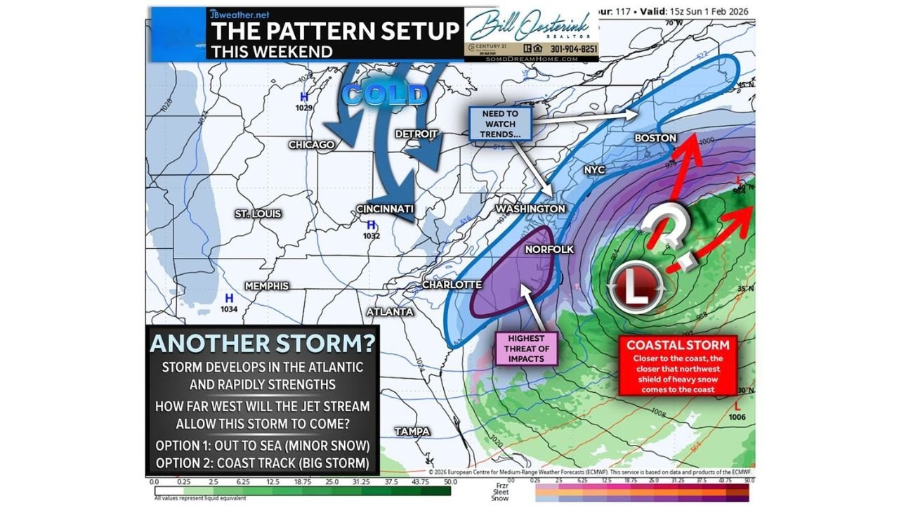
Coastal Storm Track Remains the Biggest Question
Large-scale pattern data shows a favorable setup for storm development in the Atlantic, driven by:
- Fresh injections of cold air from the jet stream
- Atmospheric blocking slowing storm progression
- A strengthening coastal low pressure system offshore
What remains uncertain is how far west the storm tracks.
Recent modeling trends lean toward a narrow miss, keeping the strongest impacts offshore and limiting snowfall along the coast. However, historical patterns show that systems like this often shift northwest as the event approaches, which could bring snow closer to land.
East Coast From the Carolinas to New Jersey Needs to Monitor Closely
Based on current data, the highest chance for snow late Saturday into Sunday exists along:
- Coastal North Carolina
- Coastal Virginia
- Portions of Maryland, Delaware, and New Jersey
This does not look like a locked-in blizzard scenario, but it does carry enough uncertainty that residents along the I-95 corridor and immediate coast should remain alert.
Even a small westward shift in the storm track could significantly change snowfall outcomes due to the extremely cold air already in place.
Bottom Line
The weekend forecast is being driven by two key factors:
- A powerful Arctic air mass plunging south into the Southeast
- A developing Atlantic storm whose exact path is still uncertain
For Alabama, the threat is dangerous cold with minimal snow impact.
For the Carolinas and parts of the Mid-Atlantic, light precipitation combined with extreme snow ratios could make even modest moisture impactful.
This setup will continue to be refined over the next 24–48 hours.
Stay with ChicagoMusicGuide.com for continued updates as the weekend forecast comes into sharper focus.