
Alabama, Tennessee, Mississippi, and the Midwest Stand Out as 2025 Tornado Warning Heat Map Reveals Extreme Severe Weather Concentration
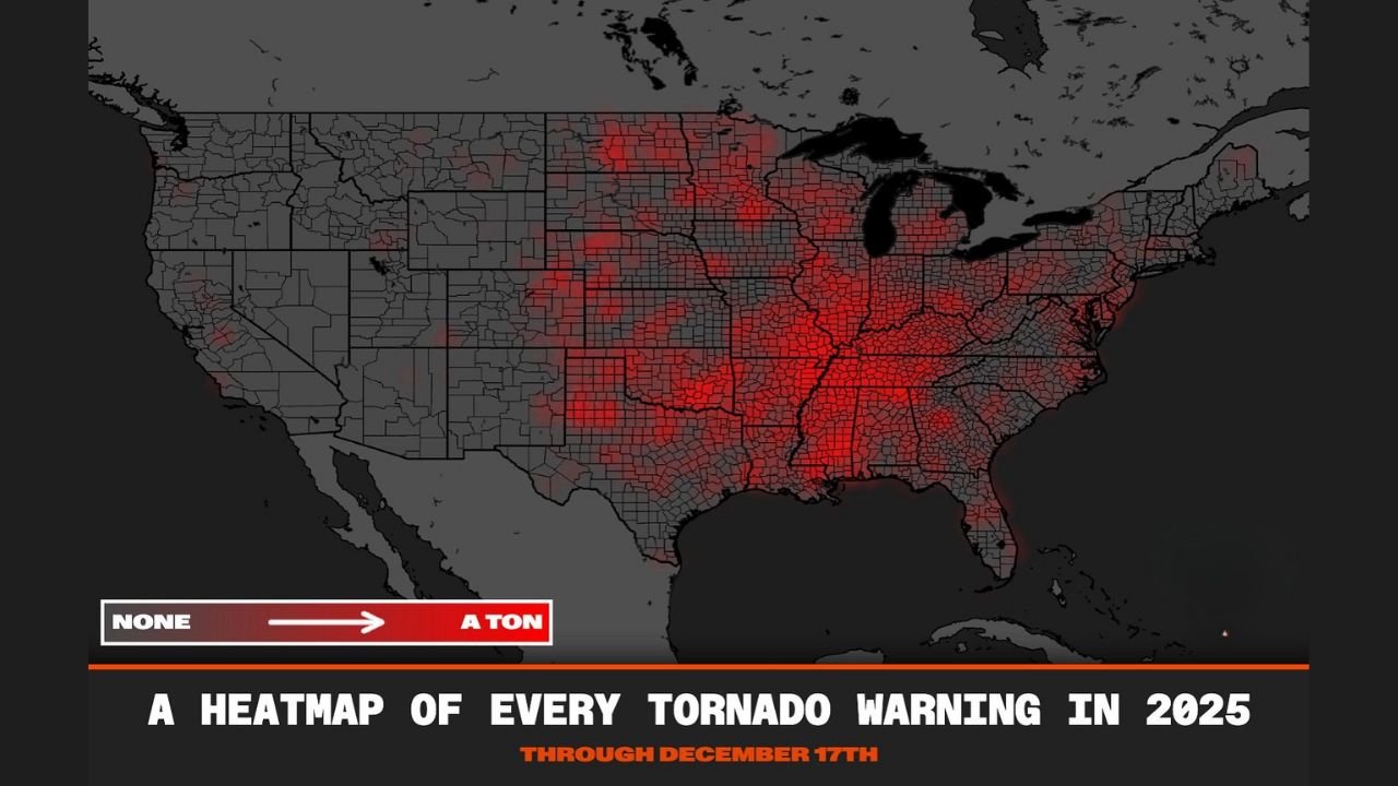
UNITED STATES — A newly released 2025 Tornado Warning Heat Map offers a striking look at where severe weather threats were most concentrated across the country this year, revealing that Alabama, Mississippi, Tennessee, Arkansas, Missouri, and large portions of the Midwest experienced the highest density of tornado warnings nationwide. Compiled through mid-December 2025, the data shows that more than 8,000 tornado warnings were issued across the United States, underscoring a season marked by shifting storm corridors and prolonged regional exposure to severe weather.
What the 2025 Tornado Warning Heat Map Shows
The heat map visualization highlights warning frequency rather than confirmed tornado touchdowns, offering insight into where atmospheric conditions repeatedly supported tornadic storms. The most intense concentrations appear across Dixie Alley, stretching from central Alabama and Mississippi through Tennessee and into the Ohio Valley, with additional hotspots extending into the central and northern Plains.
While parts of Texas and Oklahoma saw periodic activity, the data shows that the Southeast and Mid-South experienced a far more persistent warning pattern. This reflects how storm tracks repeatedly favored these regions rather than remaining confined to the traditional Tornado Alley farther west.
Why Dixie Alley Dominated the Early 2025 Season
Meteorologists attribute the early-season spike in tornado warnings to a combination of La Niña conditions and a warm-phase North Pacific Oscillation, which together helped establish a progressive upper-level storm track across the southern United States. This pattern pushed instability and wind shear eastward, increasing tornado potential across Alabama, Mississippi, and Tennessee, particularly during March and April.
Unlike classic spring setups centered on the Plains, this configuration allowed frequent severe weather outbreaks to occur farther east, often impacting densely populated areas and leading to a higher volume of warnings.
Shift Toward the Plains and Upper Midwest Later in the Year
As the year progressed, a transition toward neutral ENSO conditions allowed the Great Plains to become more active during peak spring, while late-season ridge-rider events boosted tornado potential across the Northern Plains and Upper Midwest during early summer.
States such as Missouri, Iowa, Illinois, Wisconsin, and Minnesota saw notable increases in tornado warnings during these periods. The heat map shows this northward expansion clearly, illustrating how severe weather risk migrated rather than diminished as the year went on.
Why Overall Tornado Numbers Stayed in Check
Despite the intense warning activity, total tornado counts remained somewhat moderated compared to some past years. One major factor was the absence of U.S. hurricane landfalls during the fall, which historically can generate additional tornado outbreaks inland. Without that contribution, overall tornado numbers were kept in check—even as warning issuance remained exceptionally high.
This contrast highlights how warning frequency and tornado totals don’t always align, particularly during years dominated by long-lived atmospheric patterns rather than single catastrophic events.
What This Means Looking Ahead to 2026
The 2025 season reinforced the idea that tornado risk is no longer confined to one region. With Dixie Alley continuing to show heightened vulnerability and the Plains still capable of explosive late-season activity, forecasters are already watching signals that 2026 could bring elevated risk across the southern Plains.
As climate patterns evolve, the geographic footprint of severe weather continues to expand, making year-round preparedness increasingly important for communities far beyond traditional tornado corridors.
For continued updates on national severe weather trends, seasonal outlooks, and major forecast developments, stay connected with ChicagoMusicGuide.com, where we track the stories shaping weather awareness across the country.