
Arctic Air Surge Drives Prolonged Extreme Cold Across Texas, Louisiana, Mississippi, Alabama, Georgia, Florida, Ohio, and the Mid-Atlantic Through Early February
EASTERN UNITED STATES — A powerful surge of Arctic air is spreading across the eastern half of the country, with dangerously cold temperatures expected to persist through at least Monday night, according to the National Weather Service. Forecast guidance shows the cold expanding as far south as the Gulf Coast, raising concerns for record low temperatures, extreme wind chills, and long-duration freezes across multiple regions.
Meteorologists warn that this event could rank among the longest stretches of extreme cold in decades for parts of the East and Southeast.
Arctic Air Surging South Into the Gulf Coast
The latest NWS outlook confirms that a deep Arctic air mass will continue pressing southward, reaching the Gulf Coast and Southeast and lingering into early next week. Some daily record low temperatures are expected across the Ohio Valley and Mid-Atlantic, with more widespread records possible across the Gulf Coast states through the weekend.
In parts of Florida, forecasters note the potential for rare long-duration hard freezes, an event that can have significant impacts on infrastructure, agriculture, and vulnerable populations.
Dangerously Low Wind Chills Widen Across the East
As the Arctic air settles in, strengthening winds — enhanced by a developing coastal storm near the Carolinas — are expected to drive dangerously low wind chills. Forecast data shows wind chills dropping below zero as far south as the Southern Plains and Southern Appalachians.
These conditions are especially concerning in areas dealing with ongoing or recent power outages, where exposure risks increase rapidly. Even brief outdoor exposure could result in frostbite or hypothermia.
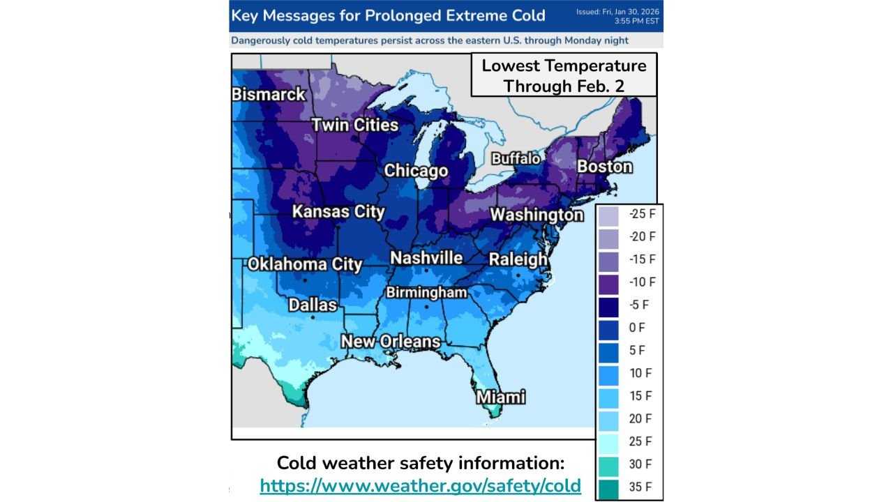
Lowest Temperatures Expected Through February 2
Temperature projections through February 2 show widespread subfreezing lows across the eastern U.S., with some regions experiencing single-digit or below-zero readings. The coldest air remains centered over the Upper Midwest, Great Lakes, and interior Northeast, but unusually cold conditions extend well into the Deep South.
While some moderation is expected later next week, forecasters stress that below-normal temperatures will dominate even after the coldest air retreats.
Florida and Southeast Face Unusual Cold Risks
The NWS highlights Florida cold concerns as a key impact area. Long-duration freezes along the Gulf Coast and Florida Peninsula could affect:
- Agricultural interests
- Unprotected pipes
- Outdoor pets and livestock
- Sensitive infrastructure not designed for extended cold
Residents in these regions are urged to take cold-weather precautions typically associated with more northern climates.
Cold Weather Safety Remains Critical
Officials emphasize that this event is not just about low temperatures, but duration. Prolonged exposure increases risks, even in areas accustomed to winter cold. Safety guidance includes:
- Limiting time outdoors
- Ensuring pets and animals have adequate protection
- Preventing frozen pipes
- Avoiding ice of unknown thickness
Emergency managers stress that preparation now can prevent serious injuries later as the cold persists.
What Forecasters Are Monitoring Next
Meteorologists are closely watching:
- The duration of the Arctic air mass
- Wind trends that could worsen wind chills
- Any reinforcement shots of cold air
- Timing and strength of eventual moderation
While temperatures will eventually rise, the current cold pattern remains firmly entrenched.
As this prolonged Arctic outbreak continues to affect millions across the eastern United States, awareness and preparation remain essential. For continued updates on extreme cold, weather safety, and national forecasts, visit ChicagoMusicGuide.com.