
California Braces for Series of Powerful Storms as Heavy Rain, Flooding Risk, and Major Sierra Nevada Snowfall Loom
SACRAMENTO, CALIF. — The National Weather Service and California River Forecast Center are warning that California is entering a highly active and potentially dangerous weather pattern, with four significant storms expected to impact the state over the next week, bringing widespread heavy rain, flooding concerns, and feet of snow in the Sierra Nevada.
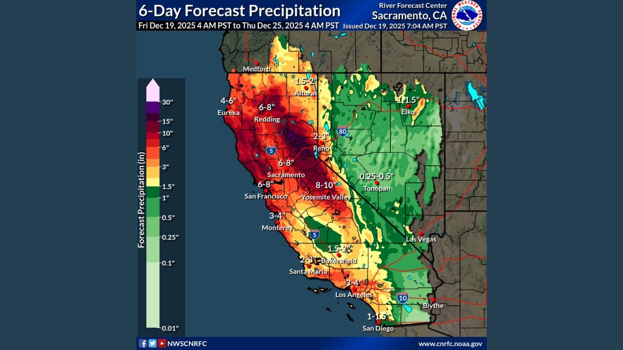
Forecast data and precipitation outlook maps show Northern California and the Sierra Nevada as the most heavily impacted areas, while Central and Southern California are also expected to see several inches of rain that could lead to travel disruptions, mudslides, and localized flooding.
Northern California and Sacramento Valley Face Highest Flood Risk
Meteorologists say Northern California, including the Sacramento Valley, is at the greatest risk as repeated rounds of rain move inland from the Pacific.
Rainfall totals over the next six days are projected to reach:
- 4 to 8 inches across much of Northern California
- 6 to 8 inches in the Sacramento and Redding areas
- 15 to 20+ inches possible along the western slopes of the Northern Sierra
Flood Watches have already been issued for the entire Sacramento Valley and the western Sierra foothills, signaling concern for rising rivers, saturated soils, and rapid runoff.
“This is a classic multi-storm setup where rainfall adds up quickly, especially in river basins and foothill communities,” forecasters noted.
Sierra Nevada Braces for 2 to 5+ Feet of Snow
While lower elevations deal with heavy rain, the Sierra Nevada will see extreme winter impacts.
Snow totals are expected to reach:
- 2 to 5+ feet at higher elevations
- Heaviest accumulations along the Northern Sierra crest
- Dangerous travel conditions on major mountain passes, including I-80 and Highway 50
The combination of heavy snowfall and strong winds may lead to whiteout conditions, road closures, and avalanche concerns.
Central and Southern California Also See Significant Rainfall
Although impacts will be less extreme than in the north, Central and Southern California are still expected to receive soaking rainfall.
Forecast totals include:
- 2 to 4 inches across much of Central California
- 2 to 4 inches in parts of Southern California, including coastal and inland valleys
- Localized higher totals along coastal ranges and foothills
Urban areas such as Los Angeles, Bakersfield, and San Diego could experience street flooding, slick roads, and minor debris flows, especially in recent burn scar areas.
Why This Storm Pattern Is Concerning
Weather models indicate that storms will arrive in quick succession, limiting the ground’s ability to absorb rainfall between systems.
Key concerns include:
- Rapid river rises in the Sacramento and San Joaquin basins
- Mudslides and rockslides in foothill and canyon areas
- Prolonged travel disruptions across mountain routes
- Power outages in areas experiencing heavy snow and wind
“The cumulative effect of multiple storms is what raises the risk level,” forecasters emphasized.
What Californians Should Do Now
Officials urge residents to prepare ahead of time:
- Avoid unnecessary travel during peak storm periods
- Never drive through flooded roadways
- Monitor river and flood alerts closely
- Mountain travelers should carry chains and emergency supplies
- Stay informed through local weather offices and emergency alerts
Emergency managers stress that conditions can change rapidly, especially as storms interact with already saturated ground.
As California heads into the heart of this active weather stretch, residents across the state are urged to stay alert, especially in flood-prone valleys and mountain regions. Additional watches and warnings are likely as each storm approaches.