
California Storm Series Begins This Week as Bay Area and Central Coast Prepare for Heavy Rain and Holiday Travel Disruptions
CALIFORNIA — A new stretch of unsettled weather is taking shape across the West Coast, with rain beginning to arrive in the North Bay tonight and spreading across the broader Bay Area from Thursday through Saturday. Forecast confidence is now increasing that multiple storm systems will continue into next week, bringing the potential for heavier rainfall right into the Christmas travel period.
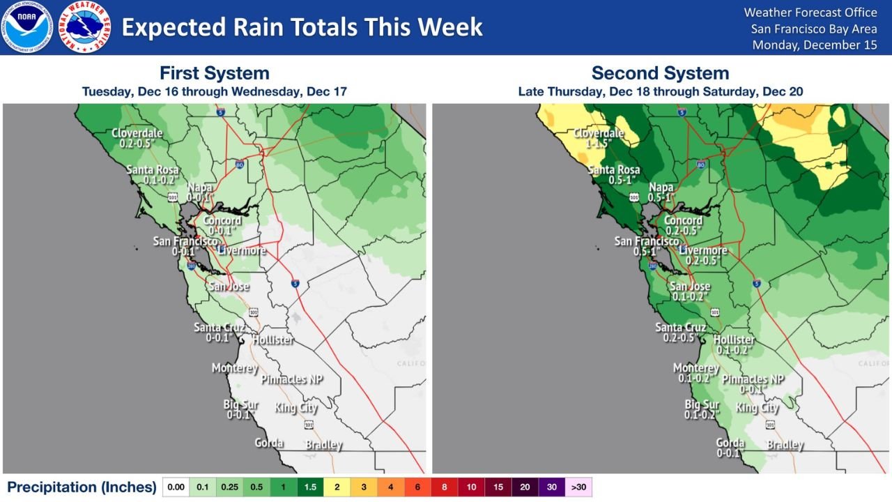
Two Storm Systems Target California This Week
Forecast maps from the National Weather Service show two separate systems arriving in close succession.
The first system, expected Tuesday through Wednesday, brings light and generally beneficial rainfall. Most locations from San Francisco south into Monterey and Big Sur are forecast to see between 0.10 and 0.25 inches, with slightly higher totals across the North Bay.
The second system, expected late Thursday through Saturday, begins a more active pattern. Rainfall zones expand deeper into the Bay Area, with projections showing 0.50 to 1.00 inch for San Francisco, Livermore, San Jose, and Santa Cruz, while the North Bay may receive 1.00 to 1.50 inches.
These early-week systems set the stage for what forecasters believe could be a longer sequence of storms.
Rising Confidence in a Holiday Storm Series
NWS forecast notes indicate growing certainty in a series of storms beginning Sunday, December 21, and continuing through the Christmas holiday period. This raises concerns for holiday travelers, particularly across the West Coast’s busiest corridors.
While exact rainfall amounts remain fluid, the discussion highlights three key tracking points:
- Placement of moisture plumes connected to Pacific systems
- How storm tracks may shift north or south
- Timing and intensity of peak rainfall and winds
Because soils in parts of Northern California remain sensitive to earlier season storms, roadway and stream flooding could redevelop even with moderate rainfall totals.
Potential Impacts Across the Bay Area and Central Coast
NWS impact tables outline several areas of concern as rainfall increases:
- Roadway and stream flooding possible where rain bands repeat
- Disruptions to holiday travel, especially around Dec. 21–25
- Worsened flooding potential due to saturated ground from earlier systems
Forecast confidence is currently rated medium, reflecting uncertainty in exact storm placement but increasing agreement that at least one strong system arrives before Christmas.
What Rainfall Totals Look Like for Sunday and Monday
The new extended forecast shows widespread totals of 1.0 to 2.0 inches from the North Bay to Monterey, with some higher elevations possibly exceeding those values. Areas such as Santa Rosa, Santa Cruz, and Big Sur appear to be positioned for the greatest rainfall.
Cities including San Francisco, Concord, Livermore, San Jose, and Hollister fall within the 0.50 to 1.00 inch range for the early part of next week.
Given the possibility of multiple storms arriving back-to-back, these totals may increase as updated models are released.
Stay Weather-Aware This Week
California’s storm pattern is shifting quickly, and additional updates are expected as confidence grows in the holiday storm sequence. Residents and travelers should monitor local forecasts closely, especially if planning road trips between December 21 and Christmas Day.
What do you think about California’s upcoming storm pattern? Share your thoughts and follow ChicagoMusicGuide.com for more weather coverage and updates.