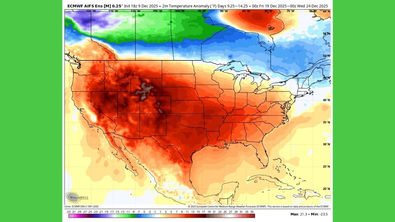
California, Texas, and Much of the Western and Southern U.S. Expected to Warm Significantly After Recent Cold Spell, Bringing Above-Average Temperatures Into Late December

UNITED STATES — A Broad Warm-Up Is Expected to Take Hold Across the Country Following the Recent Cold Outbreak, A major shift in the national temperature pattern is emerging as the United States transitions away from its early-December cold spell. Large portions of the West, South, and even parts of the Midwest and East are expected to trend above average heading into the December 19–24 period.
The temperature outlook highlights a dramatic expansion of warmer-than-normal air across California, Nevada, Arizona, New Mexico, Texas, Oklahoma, Arkansas, Tennessee, Georgia, and much of the central and eastern U.S., marking a widespread reversal from the colder conditions seen earlier this month.
Warm Conditions Dominate California, the Southwest, Texas, and the Central U.S.
The most noticeable temperature jump is centered over the western half of the country.
Warmest Regions Expected
- California — Widespread warmth spreads north and south across the state
- Nevada, Utah, and Arizona — A significant surge of above-average temperatures
- New Mexico and Colorado — Warmer-than-normal conditions extend across the Rockies
- Texas, Oklahoma, Kansas, and Arkansas — A broad warm plume pushes into the Southern Plains and Mississippi Valley
The temperature anomaly map shows deep red shades stretching from the West Coast into the central U.S., signaling a strong return to comfortable and unseasonably mild conditions.
Many regions could see afternoon highs running 10–20°F above typical late-December levels, especially across the Southwest and Southern Plains.
A More Mixed Pattern for the Midwest and Northeast
While most of the country trends warmer, the Upper Midwest, Great Lakes, and far Northeast still hold onto pockets of cooler-than-normal air.
Cooler Areas Include:
- North Dakota and northern Minnesota
- Northern Wisconsin and Michigan’s Upper Peninsula
- Parts of upstate New York and northern New England
These cooler zones appear limited and relatively narrow, surrounded on all sides by expanding warmth to the west, south, and southeast.
What’s Driving the Warm-Up?
A broad shift in the upper-level pattern allows warmer air to spread across most of the U.S., replacing the cold, unsettled conditions that dominated earlier in December.
Key features shaping this trend include:
- A stronger influence of mild Pacific air moving inland
- Retreat of the earlier cold air mass toward Canada
- A period of stable and quieter weather for many states
This setup resembles the kind of warmth seen during December 2021, which was widely noted for its persistent above-average temperatures across large portions of the country.
Potential Impacts of the Warming Trend
1. Travel Conditions Improve for Many Regions
Warmer temperatures reduce the likelihood of widespread ice or snow issues across the central and southern states.
2. Energy Demand May Drop Slightly
Less heating will be required in areas experiencing unusually warm afternoons.
3. Snowpack and Winter Recreation Conditions May Suffer in the West and Central U.S.
Warmer temperatures could slow snowfall accumulation in mountains outside the far northern states.
4. Northern Tier Still Needs to Watch for Cold Intrusions
Although the trend is warmer overall, the far northern states may still see brief cold snaps due to lingering cooler air.
Looking Ahead
If the current pattern holds through the final third of December:
- Most of the U.S. — Warm, mild conditions dominate
- West & Southwest — Strongest warm anomalies
- South & Southeast — Extended warmth into Christmas week
- Northern states — Occasional cool spells but much less severe than earlier in the month
This warm stretch could continue into late December before new patterns develop closer to the New Year.
Stay tuned to ChicagoMusicGuide.com for continued nationwide weather coverage and seasonal updates.
