
California, Texas, Arizona, and Much of the Western and Southern United States Expected to See Significantly Above-Normal Temperatures Leading Into Christmas Week
UNITED STATES — A broad stretch of unusually warm December weather is expected to take over much of the western and southern United States between December 17 and December 23, signaling the strong possibility of what meteorologists often refer to as a “Torchmas.”
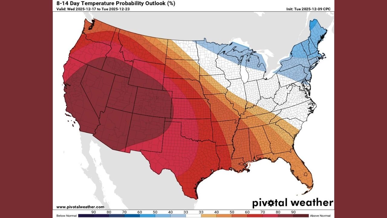
The latest 8–14 Day Temperature Probability Outlook from the Climate Prediction Center (CPC) shows a large, deep red zone covering California, Nevada, Arizona, Utah, New Mexico, Colorado, Texas, Oklahoma, and Arkansas, indicating a very high likelihood of above-normal temperatures leading into Christmas week.
This expansive warm anomaly suggests that millions of Americans may experience mild, springlike conditions during a period that is normally dominated by winter chill.
Western U.S. to See the Strongest Warm Signal
The warmest probability zone stretches from the Pacific coast through the interior West. States most heavily impacted include:
- California — widespread above-normal temperatures from the coast to the Central Valley and deserts
- Nevada & Utah — strong warming likelihood across most elevations
- Arizona — high probabilities for above-normal daytime highs
- Oregon & Washington (southern portions) — warmer-than-normal temperatures extending into the Pacific Northwest
This signal suggests a continuation of the dry, mild pattern that often emerges during mid-December atmospheric ridging events.
Southern States From Texas to Alabama Also Trending Much Warmer Than Normal
The warm pattern expands eastward across the Deep South, with elevated probabilities for above-average temperatures in:
- Texas
- Oklahoma
- Louisiana
- Mississippi
- Alabama
- Georgia
- Florida (western sections)
Residents across these states may see afternoon highs well above seasonal norms, with some locations feeling more like early autumn than mid-December.
Central Plains and Midwest: Gradual Warm-Up After Recent Cold Spells
The warm temperature probability band also spreads into parts of the central United States, including:
- Kansas
- Nebraska
- Missouri
- Iowa (southern section)
- Illinois (central and southern regions)
While not as extreme as the western heat signal, this region still shows a clear trend toward milder-than-normal conditions, offering a notable shift from recent Arctic outbreaks.
Northern and Northeastern States Show a Split Pattern
The Northeast and Great Lakes are the only regions showing a meaningful departure from the widespread warmth.
The outlook highlights below-normal temperatures for:
- Maine
- New Hampshire
- Vermont
- Northern New York
- Northern Michigan
This colder zone reflects the potential for lingering Canadian air intrusions, creating a stark contrast with the warm anomalies spreading elsewhere.
What Is Driving This “Torchmas” Pattern?
Meteorologists point to several atmospheric factors:
- A dominant upper-level ridge over the western and southern United States
- Suppressed storm activity across much of the country
- Enhanced west-to-east flow keeping cold air bottled up in far northern latitudes
- Potential influence from ongoing La Niña background patterns
Together, these elements create an environment highly favorable for sustained warmth.
What This Means for Holiday Travel and Outdoor Activities
For millions of Americans planning to travel or attend holiday events, the warmer weather may offer some advantages:
- Reduced winter travel hazards across the West and South
- Lower risk of snow and ice for major interstates from California to Texas
- More comfortable outdoor conditions for pre-Christmas festivities
However, the warmth may also deepen ongoing drought concerns in the Southwest.
The CPC’s mid-December outlook strongly suggests that much of the western and southern United States will experience a warm lead-up to Christmas, with unusually high confidence in above-normal temperatures across California, Texas, Arizona, Nevada, Colorado, New Mexico, and surrounding states.
Only parts of New England and the northern Great Lakes show a tendency toward colder-than-normal weather.
Although the pattern may still shift, the current outlook points toward a mild, snow-limited Christmas season for much of the country — fueling what many call a likely “Torchmas.”
Stay with ChicagoMusicGuide.com for continuing updates on evolving weather patterns across the United States.