
Colorado Records One of the Highest Early December Snow Cover Totals in 20 Years as U.S. Snow Extent Surges to 45%
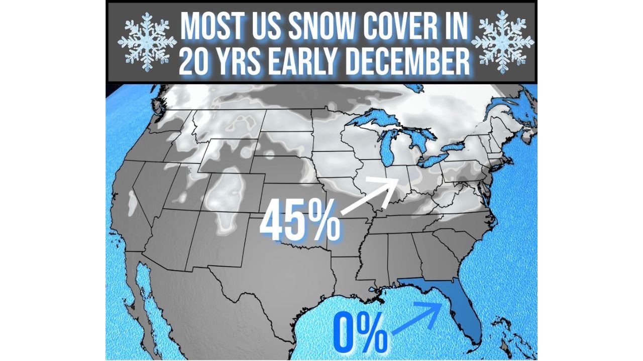
DENVER, CO — New national snow analyses show the United States experiencing one of the most expansive early-December snow coverage events in the last 20 years, with 45% of the country blanketed in snow, according to data from the Automated Multisensor Snow and Ice Mapping System.
This places early December 2025 among the snowiest starts to December in two decades, driven by a series of strong cold fronts and multiple early-season winter storms sweeping through the Rockies, Upper Midwest, and interior Northeast.
Colorado, Wyoming, Utah, Montana, the Dakotas, Minnesota, Wisconsin, Michigan, and parts of the Ohio Valley all contributed to the unusually widespread coverage.
U.S. Snow Cover Reaches 45% — Highest Early December Level Since Mid-2000s
The satellite-derived snow map shows nearly half the continental U.S. covered in snow, a level typically seen later in the winter season rather than the first week of December.
Key highlights:
- 45% snow coverage across the U.S.
- Widespread snowpack from the Rockies through the Midwest
- Expanded coverage into the Great Lakes region
- Strong cold outbreaks supporting sustained accumulation
This is a sharp contrast to the 0% snow coverage measured in Florida, which remains snow-free and tied for both “most” and “least” early-December snow on record due to its extremely consistent warm climate.
Northern Hemisphere Snow Levels Show Regional Extremes
While the U.S. is experiencing near-record early December snow cover, the Northern Hemisphere overall is running below average, particularly across Eurasia.
Two comparative graphs illustrate the contrast:
Northern Hemisphere Total (Top Graph):
- 2025–2026 season tracks slightly below the 20-year mean
- Snow extent is lower than many previous years
- Early December levels remain modest despite U.S. surges
Eurasia (Bottom Graph):
- Shows a clear deficit compared to multi-year averages
- Several regions have struggled to maintain early-season snowpack
- Weather patterns have favored warmth and reduced snowfall
This creates an unusual situation:
The U.S. is snowy, but Eurasia remains historically low for early December.
Why the U.S. Snow Coverage Is So High This Year
Meteorologists point to several drivers:
- Strong early-season cold fronts sweeping through the Rockies and Midwest
- Enhanced storm tracks delivering repeated snow systems
- Persistent below-normal temperatures across central and northern states
- Active jet stream patterns keeping cold air locked into the central U.S.
These conditions combined to produce a widespread early snowpack rarely observed in late autumn.
Impacts on Travel, Events, and the Music Community
With nearly half the country under snow, early December has brought:
- Flight delays across Denver, Minneapolis, Chicago, and Detroit
- Road travel disruptions in the Rockies and Midwest
- Outdoor venue closures or schedule changes
- Cold-weather challenges for touring crews transporting equipment
Artists traveling to or through snowy regions are advised to prepare for:
- Longer load-in and travel times
- Cold-sensitive equipment performance issues
- Potential weather-related rerouting
Meanwhile, southeastern touring routes — including Florida, Georgia, and coastal Carolina cities — remain free of winter impacts for now.
Looking Ahead: Will the Snow Trend Continue?
Forecast models hint that additional arctic fronts may develop mid-month, potentially increasing U.S. snow coverage even further.
However, Eurasia’s below-normal snowpack suggests larger global atmospheric patterns are still in flux — meaning future snowfall may depend heavily on upcoming jet stream shifts.
ChicagoMusicGuide will continue monitoring seasonal snow trends as winter 2025–2026 develops.
How is early winter weather affecting your travel or performance plans? Share your experiences at ChicagoMusicGuide.com!