
Colorado, Utah, and Wyoming Rockies Poised for Major Snowpack Surge as NOAA Flags High Heavy Snow Risk
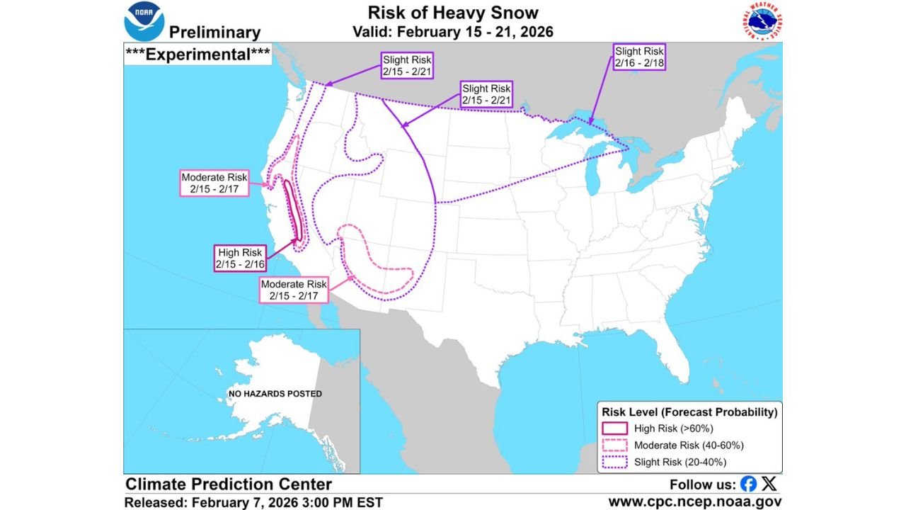
UNITED STATES — A powerful winter pattern taking shape across the western United States is setting the stage for significant snowpack growth in the Rocky Mountains, as the NOAA Climate Prediction Center (CPC) highlights widespread heavy snow risk between February 15 and February 21. Forecast maps show multiple tiers of risk stretching from the Pacific Coast ranges into the Intermountain West and Rockies, reinforcing confidence that mountain regions are heading toward one of their snowiest stretches of the season.
The outlook supports earlier model trends calling for a colder, stormier regime that favors repeated snow-producing systems, rather than a single short-lived event.
High Risk Zone Targets the Central and Southern Rockies
The CPC’s experimental heavy snow outlook places a High Risk (greater than 60 percent probability) over portions of the central and southern Rockies, including parts of Colorado, Utah, and northern New Mexico, during the February 15–16 timeframe. This designation signals a strong likelihood of significant snowfall capable of rapidly building snowpack at higher elevations.
These areas are well-positioned to benefit from sustained cold air and deep moisture, increasing the chances for prolonged periods of heavy mountain snow.
Moderate Risk Expands Across the Interior West
Surrounding the core high-risk zone, a broad Moderate Risk (40–60 percent probability) extends across the Great Basin, interior California ranges, and additional sections of the Rockies from February 15–17. This suggests multiple storm systems may impact the region in quick succession, reinforcing totals rather than relying on a single storm.
Mountain corridors across Nevada, Utah, western Colorado, and Wyoming fall within this zone, pointing to widespread accumulations and growing seasonal snow totals.
Slight Risk Reaches the Pacific Northwest and Northern Plains
Farther north, the CPC highlights a Slight Risk (20–40 percent probability) of heavy snow across the Pacific Northwest, northern Rockies, and portions of the northern Plains, valid through February 21. While impacts here may be more intermittent, the extended duration increases the odds of meaningful accumulation over time, especially in favored terrain.
This broader footprint underscores the scale of the pattern, with winter weather influencing much of the western half of the country.
Why Snowpack Could End Up Impressive
What makes this setup notable is longevity. Rather than a brief cold snap, the pattern supports:
- Repeated storm tracks into the West
- Consistently cold temperatures at elevation
- High snow-to-liquid ratios in the Rockies
- Limited melt between systems
Taken together, these factors point toward substantial snowpack gains by late February, particularly in high alpine basins and ski resort regions.
Implications for Travel, Water Supply, and Ski Season
While heavy snow brings challenges for mountain travel and pass closures, the upside is significant. A deepening snowpack improves late-season ski conditions and contributes positively to spring water supply across much of the West.
Resorts in the Colorado Rockies, Wasatch, Tetons, and Sierra-adjacent ranges stand to benefit from improved base depth and sustained powder conditions.
What to Watch as the Window Approaches
Although confidence is high in an active pattern, exact impacts will depend on:
- Storm spacing and intensity
- Wind and blowing snow potential
- Snow levels during each system
- Localized terrain enhancement
Forecasters will continue refining snowfall placement as the February 15–21 window draws closer.
With NOAA now highlighting elevated heavy snow risk, it’s increasingly clear that the Rockies are on track to emerge from this stretch with an impressive snowpack. For continued long-range outlooks, winter storm updates, and mountain weather coverage, visit ChicagoMusicGuide.com.