
East Texas, Louisiana and Southwest Mississippi Upgraded to Slight Risk as Tornado and Damaging Wind Threat Grows Saturday Night
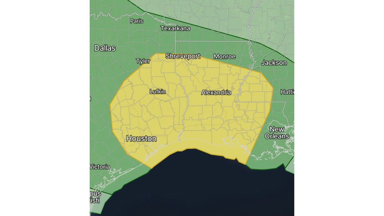
SHREVEPORT, LOUISIANA — The Storm Prediction Center (SPC) has upgraded much of east Texas, central and southern Louisiana, and southwest Mississippi to a Slight Risk (Level 2 of 5) for Saturday, signaling growing confidence in the potential for a few tornadoes and damaging wind gusts as an intensifying line of storms moves through the region.
The upgrade highlights an evolving setup expected to unfold Saturday evening into the overnight hours across this corridor.
Slight Risk Expands Across Key Gulf States
The updated risk area covers a broad swath of the western Gulf Coast region, including:
- East Texas, including areas near Tyler, Lufkin, and Houston
- Much of Louisiana, including Shreveport, Alexandria, and Monroe
- Parts of southwest Mississippi, west of Jackson
Cities such as Houston, Shreveport, and Alexandria sit squarely within the yellow-shaded Slight Risk zone, indicating a more organized severe weather threat compared to the surrounding Marginal Risk areas.
The primary hazard appears to be tied to a strengthening QLCS (Quasi-Linear Convective System) expected to sweep eastward during the evening and overnight.
Tornado and Damaging Wind Threat Increasing
Forecasters note increased confidence in:
- Damaging wind gusts
- Embedded tornadoes within the line of storms
QLCS events can produce quick, spin-up tornadoes that develop along bowing segments of the storm line. These tornadoes are often short-lived but can still cause localized damage.
The timing of the system — moving in during the evening and overnight hours — raises additional concern, as nighttime severe weather can catch residents off guard.
Communities from Houston northeast toward Shreveport and Monroe should be especially prepared for rapidly changing conditions.
Saturday Evening Into Overnight Timing
Current projections suggest storms will intensify during the late afternoon and evening over east Texas, then move into Louisiana and southwest Mississippi overnight.
The corridor of concern extends from the Texas–Louisiana border eastward toward the Mississippi River.
Strong wind shear in the lower atmosphere is expected to support rotation within segments of the line, even if instability remains modest.
This setup is less about isolated supercells and more about a consolidated line capable of producing:
- Widespread strong wind gusts
- Brief embedded tornadoes
- Heavy rainfall
Areas Outside the Slight Risk
Locations north of the Slight Risk boundary — including areas near Texarkana and Dallas — remain in a lower risk category.
Similarly, areas farther east toward New Orleans and central Mississippi remain under a Marginal Risk, though strong storms could still occur.
The northern edge of the Slight Risk boundary runs near the Arkansas–Louisiana border, emphasizing that slight track or timing shifts could alter local impacts.
Preparedness Recommended Ahead of Nighttime Storms
Given the overnight timing, residents are urged to:
- Ensure weather alerts are enabled on mobile devices
- Have multiple ways to receive warnings
- Identify a safe shelter location away from windows
Even brief tornadoes within a QLCS can cause tree damage, power outages, and structural impacts.
As confidence increases in this setup, forecasters will continue refining the storm track and intensity expectations through Saturday.
For continued updates on Gulf Coast severe weather, tornado risk developments, and weekend storm tracking, visit ChicagoMusicGuide.com for the latest coverage.