
Eastern Kentucky Faces Uncertain Snowfall Outlook as Multiple Systems Bring Light Snow and Colder Air Through Saturday Night
EASTERN KENTUCKY — Forecast guidance from the National Weather Service indicates that multiple passing weather systems will impact Eastern Kentucky from Friday through Saturday night, bringing periods of light snow showers along with a push of colder air into the region. While snowfall is expected to be generally light for most areas, uncertainty remains high regarding exact accumulation amounts, prompting close monitoring through the weekend.
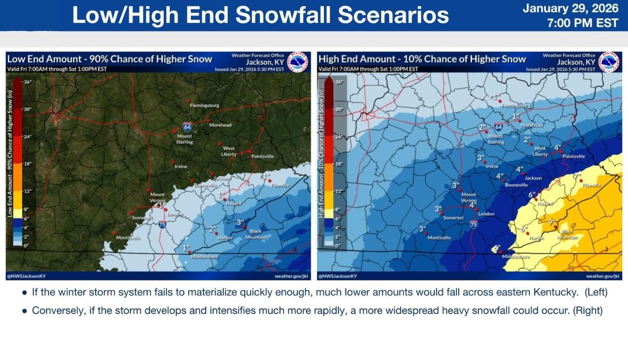
Meteorologists caution that even minor shifts in storm development could significantly change snowfall outcomes across parts of eastern and southeastern Kentucky.
Passing Systems Bring Light Snow Potential Across Eastern Kentucky
According to forecast analysis, a couple of weak systems will track through the Ohio Valley, producing intermittent snow showers across much of Eastern Kentucky. These systems are not expected to be particularly strong individually, but their combined effect could lead to periodic snowfall over an extended timeframe.
Most locations are expected to see light accumulations, particularly north and west of the Cumberland Plateau. However, timing overlaps between systems and colder air arrival could briefly enhance snowfall rates in localized areas.
Low-End vs High-End Snowfall Scenarios Explained
The National Weather Service in Jackson, Kentucky, outlines two primary snowfall scenarios based on how quickly the winter system organizes:
- Low-End Scenario (90% likelihood):
If the system fails to materialize quickly enough, much lower snow totals would occur across Eastern Kentucky, with many locations seeing only a dusting to around 1–2 inches, mainly in southern and southeastern counties. - High-End Scenario (10% likelihood):
If the storm develops and intensifies more rapidly, a broader area of heavier snowfall could occur. In this case, totals of 3–4 inches would be possible across central and eastern counties, with locally higher amounts approaching 5–6 inches toward far southeastern Kentucky near the Virginia border.
Colder Air Could Increase Impacts Despite Lower Totals
Regardless of snowfall amounts, a noticeable shot of colder air is expected to move into the region late this week and through the weekend. Temperatures falling below freezing could allow snow to accumulate more efficiently, especially during nighttime hours.
Cold ground temperatures combined with light but persistent snowfall may lead to slick roads, particularly on bridges, elevated surfaces, and untreated secondary roads.
Cold Weather Headlines Possible Later This Week
Due to lingering uncertainty in snowfall totals and the incoming colder air mass, cold weather advisories or winter weather headlines remain possible for parts of Eastern Kentucky. Officials emphasize that even low snowfall totals can cause disruptions when paired with freezing temperatures.
Residents are encouraged to monitor forecast updates, especially those planning travel from Friday through Saturday night, when conditions may change quickly.
What Forecasters Are Watching Next
Key factors that will determine final snowfall outcomes include:
- Speed and strength of incoming systems
- Timing of colder air arrival
- Duration of snow showers
- Potential for brief intensification periods
These elements will clarify whether Eastern Kentucky remains on the low-end snowfall path or shifts closer to a higher-impact scenario.
As Eastern Kentucky moves into an active late-week weather pattern, forecast confidence will continue to improve with time. For continued updates on winter weather, snowfall outlooks, and regional forecasts, visit ChicagoMusicGuide.com.