
European Model Shows Strong Cold Bias in Mid-Atlantic After D.C. Snowstorm, Raising Questions About Upcoming Forecast
WASHINGTON, D.C. — New model bias data suggests the European weather model (ECMWF) has been running noticeably colder than reality across the Mid-Atlantic following the recent snowfall event in the nation’s capital. Forecasters are now examining whether lingering snowpack feedback is influencing temperature projections and potentially impacting upcoming winter storm forecasts.
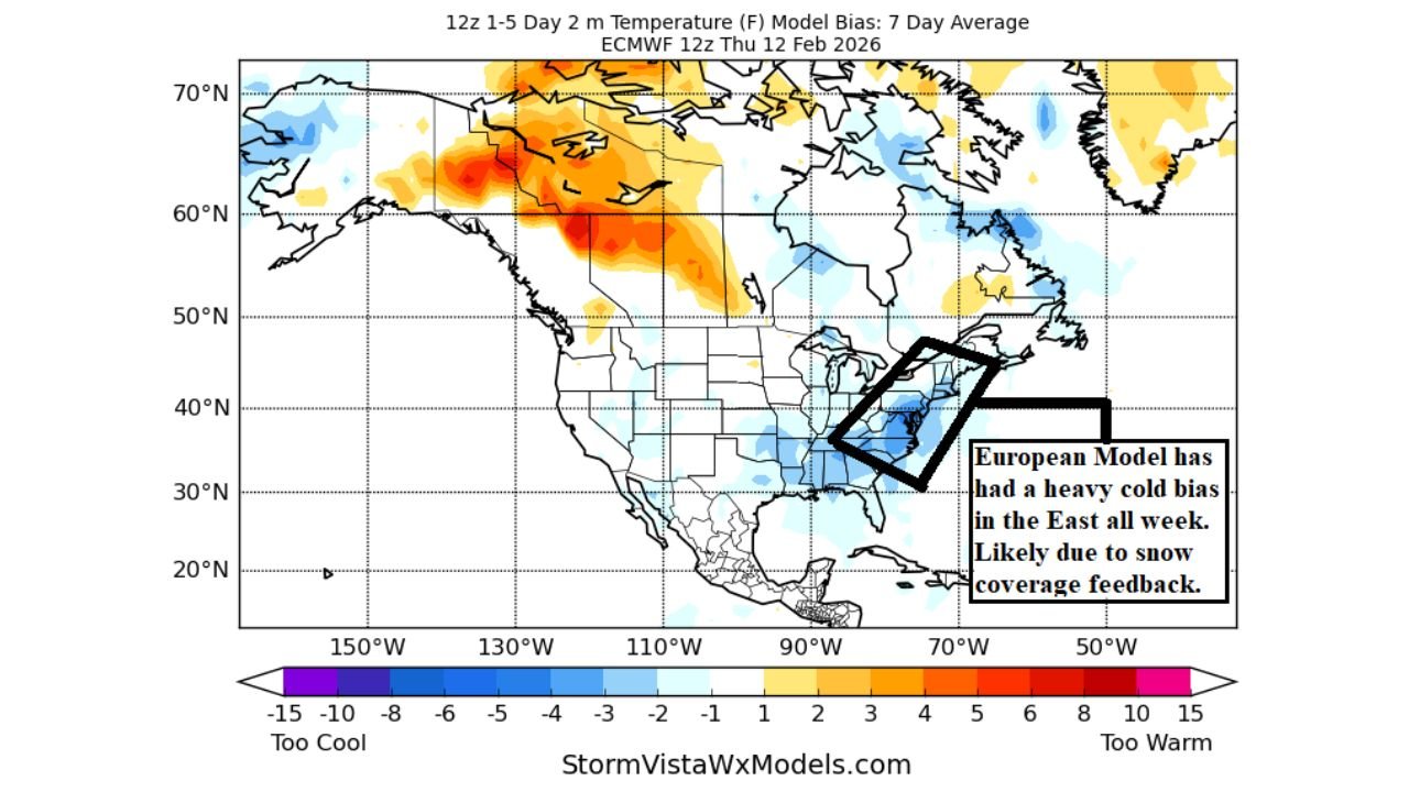
A 7-day average temperature bias graphic valid February 12 shows the ECMWF trending too cold across Washington, D.C., Virginia, Maryland, and parts of the eastern United States, with negative anomalies highlighted in blue across the region.
European Model Showing Persistent Cold Bias
The bias map indicates that during the past week, the ECMWF’s 2-meter temperature projections have averaged several degrees colder than observed across the Mid-Atlantic corridor. The cold bias appears most concentrated from Washington, D.C. southward into Virginia and portions of the Carolinas.
Forecasters note that this trend began following the significant snowfall event in D.C. The European model had projected multiple nights of single-digit low temperatures after the storm. However, actual temperatures in Washington, D.C. never dropped below 10°F during the cold outbreak.
That discrepancy has raised questions about whether the model may be overcompensating for snow cover effects.
Snowpack Feedback May Be Influencing Temperatures
One leading theory involves snow coverage feedback, where models assume persistent snowpack leads to enhanced nighttime cooling and lower daytime highs. While snow on the ground can indeed promote colder temperatures by reflecting sunlight and increasing radiational cooling, overestimating its coverage or depth can exaggerate cold forecasts.
The bias graphic highlights a defined cold zone stretching from Pennsylvania through Virginia and into parts of North Carolina, suggesting the model may be applying too aggressive a cold signal in snow-covered regions.
Meteorologists often monitor model bias trends closely because repeated over- or underestimation can skew future forecasts — particularly in borderline winter setups where a degree or two makes the difference between rain and snow.
Implications for Sunday Night Storm Potential
This bias becomes especially important ahead of the upcoming Sunday night system expected to move across parts of the Mid-Atlantic. If the European model continues to overemphasize cold air at the surface, it could exaggerate the southern extent of wintry mixing.
Forecasters are considering whether the ECMWF may be too aggressive in pushing cold air farther south than reality would support — especially if storm precipitation tracks far enough north to introduce warmer air into the region.
Even subtle differences in temperature profiles can determine:
- Rain versus snow
- Rain mixed with wet snow
- Minor accumulation versus none
Given the model’s recent cold performance bias, some meteorologists are approaching its wintry projections with caution.
Comparing Model Guidance Moving Forward
While the ECMWF is often regarded as one of the most reliable global models, no single model is immune to systematic bias. The recent cold tendency across the East contrasts with other guidance that has handled temperature profiles more conservatively.
As new model runs are released, forecasters will compare ensemble trends and real-time observations to determine whether the cold bias persists.
Monitoring bias patterns is a key part of modern forecasting, especially during transitional late-winter setups when ground conditions play an outsized role in surface temperature projections.
What This Means for the Mid-Atlantic
For residents in Washington, D.C., Maryland, Virginia, and surrounding states, the takeaway is not that a major winter storm is imminent — but rather that forecast confidence depends heavily on accurate temperature modeling.
If the European model corrects its cold bias, mixing lines and precipitation types may shift northward. If the bias continues, colder scenarios may remain in play.
As winter systems approach, subtle temperature differences could determine travel impacts and event planning across the region.
For continued updates on evolving winter forecasts and how model trends may influence regional weather patterns, visit ChicagoMusicGuide.com.