
Exceptionally Strong 1053 mb High-Pressure System Poised to Send Brutal Arctic Cold Across the Midwest
MIDWEST — A Rare 1053 mb High-Pressure System Is Setting Up a Deep Arctic Surge, The Midwest is bracing for what could become one of the most significant early-winter cold outbreaks in recent years as weather models highlight a massive 1053 mb surface high-pressure system forming over the northern Rockies. Once established, this high will act as a powerful engine, forcing a dense Canadian arctic air mass directly into the heart of the Midwest.
Meteorologists describe the evolving pattern as “wild,” noting that the Pacific jet stream, a vintage Canadian cold pool, and an unusually strong surface high are all aligning to send temperatures crashing.
The core of the cold is tracking straight toward Iowa, Illinois, Missouri, Indiana, Wisconsin, and surrounding areas.
Dynamic Tropopause Maps Show a Direct Canadian Cold Plunge Toward the Midwest
Tropopause potential temperature maps reveal a sharply carved lobe of frigid northern air plunging far southward. This feature shows:
- A massive cold pool extending from Canada
- A direct trajectory into the Midwest
- Increasing amplification over time
As the cold dome deepens, the pressure gradient strengthens — accelerating the southward push of arctic air.
This is the classic signature of a high-impact December cold wave.
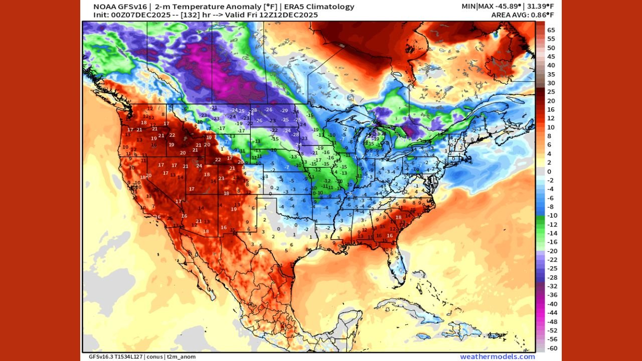
Temperature Anomaly Maps Show 20–30°F Below Normal Across Several Midwest States
GFS temperature anomaly projections for December 12–14 show widespread, intense departures from normal:
- Iowa: 20–30°F below average
- Illinois: 15–25°F below average
- Missouri: 18–28°F below average
- Indiana: 10–20°F below average
- Wisconsin & Minnesota: 18–30°F below average
Large areas appear shaded in deep purple and pink — colors typically reserved for severe mid-winter cold events.
If these values verify, the Midwest would experience its coldest air since February.
A 1053 mb High-Pressure System: The Key Driver Behind the Outbreak
Surface pressure analyses show a dominating 1053 mb high-pressure system forming next Friday — an exceptionally strong value rarely seen outside of major arctic events.
Meteorologists emphasize:
- 1053 mb indicates extremely dense cold air
- Highs above 1050 mb often precede dangerous wind chills
- These systems can rapidly transport cold southward
The pressure setup strongly favors an aggressive push of arctic air into the Midwest corridor.
Pacific Energy Adds Momentum to the Pattern
Forecasters also highlight significant activity in the Pacific:
- A stretched, energized jet stream
- Wave breaking events funneling energy toward North America
- Reinforced cold air feeding into the high-pressure ridge
This interaction helps “lock in” the cold, allowing it to spill into the central U.S. with little resistance.
What the Midwest Should Prepare For
Based on current model trends, residents across the Midwest may face:
- Wind chills well below zero
- Rapid temperature drops
- Hard freezes even in areas that have remained mild so far
- Potential impacts on travel, outdoor events, and weekend activities
Music fans, concert venues, and winter event planners should be alert — conditions may deteriorate quickly late next week.
Updates Expected as Models Continue Sharpening the Outlook
Meteorologists caution that while timing and exact temperatures may shift, the signal for a major Midwest cold outbreak is strong and growing stronger with each new model cycle.
Chicago Music Guide will continue tracking updates as the Arctic blast approaches.
Have you experienced unforgettable Midwest winter concerts or events in extreme cold? Share your stories at ChicagoMusicGuide.com!