
Florida, Georgia, Alabama, Mississippi, Tennessee, Kentucky, Ohio, Pennsylvania and New York Brace for Brutal Arctic Cold as Wind Chills Plunge Into Single Digits and Below Zero
UNITED STATES — A massive Arctic air outbreak continues to grip large portions of the eastern United States, driving dangerously low wind chills from the Midwest and Great Lakes all the way south into the Deep South and Florida, where conditions more typical of winter storms up north are now being felt.
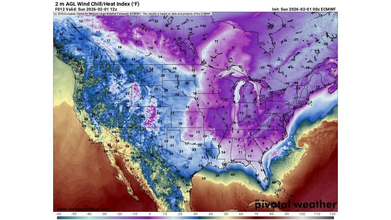
According to wind chill and temperature analysis valid Sunday morning, much of the eastern half of the country is locked under a deep freeze, with feels-like temperatures ranging from below zero in the Midwest and Great Lakes to the low teens across Florida, an extremely rare setup for late January into early February.
Arctic Air Pushes Deep Into the Southeast and Florida
Forecast wind chill maps show Florida experiencing wind chills between 10 and 15 degrees, particularly across northern and central parts of the state. While actual air temperatures remain slightly higher, persistent winds are dramatically increasing cold exposure, leaving residents unaccustomed to winter conditions facing uncomfortable and potentially hazardous cold.
Across Georgia, Alabama, Mississippi, and Tennessee, wind chills are widely falling into the single digits, with some inland areas dipping below zero, especially overnight and during early morning hours.
Midwest and Great Lakes See the Coldest Conditions
The core of the Arctic air mass remains centered over the Midwest and Great Lakes, where wind chills are plummeting to -10°F to -25°F in parts of Illinois, Indiana, Michigan, Wisconsin, and Ohio. These values represent life-threatening cold exposure if proper precautions are not taken.
Farther east, Pennsylvania and New York are also locked into extreme cold, with widespread negative wind chills continuing through the overnight period. Conditions across these states remain severe enough to cause rapid frostbite on exposed skin in as little as 15 to 30 minutes.
Why This Cold Is So Dangerous
This event is being driven by a strong Arctic high pressure system, allowing frigid polar air to spill southward with little resistance. While winter cold is common in northern states, the southward extent of this outbreak is highly unusual, especially for Florida, where sustained wind chills near 10°F are rarely observed.
Meteorologists stress that wind chill, not just temperature, is the main danger, as strong winds rapidly strip heat from the body. Even brief outdoor exposure can become hazardous without adequate protection.
What to Expect Next
While gradual moderation is expected later in the week, cold conditions will persist through the short term, especially overnight and during early mornings. Areas across the Midwest, Great Lakes, and Northeast will be the slowest to recover, while the Southeast and Florida should see gradual improvement once winds relax.
Until then, residents are urged to limit time outdoors, protect pets and pipes, and check on vulnerable individuals who may be exposed to the cold.
Safety Reminders During Extreme Cold
- Dress in multiple layers, including hats and gloves
- Bring pets indoors
- Protect exposed plumbing
- Avoid unnecessary travel during peak cold periods
- Watch for signs of hypothermia and frostbite
Stay with ChicagoMusicGuide.com for continued nationwide weather coverage, cold-weather alerts, and updates as this Arctic outbreak slowly loosens its grip. What are conditions like where you live? Share your experience with us.