
Four-State Region Winter Storm Intensifies as Sleet Nears 2 Inches and Ice Accretion Continues Across East Texas, North Louisiana, Southern Arkansas, and Western Mississippi
UNITED STATES — A dangerous Winter Storm continues to impact the Four-State Region, with the National Weather Service in Shreveport (NWS SHV) reporting significant sleet and ice accumulation as of 9 PM CST on January 24, 2026. Officials confirm the storm has already produced 1.7 inches of sleet and 0.13 inches of freezing rain (ice) accretion, with additional accumulation expected as the event remains ongoing overnight.
The combination of heavy sleet and ice is creating increasingly hazardous conditions across East Texas, North Louisiana, southern Arkansas, and western Mississippi, where travel, power infrastructure, and emergency response efforts are all being strained.
Latest Winter Storm Accumulation Totals from NWS Shreveport
According to NWS SHV’s latest event summary, the storm has already reached impactful levels in several areas. Sleet accumulation nearing 2 inches is particularly concerning, as sleet compacts quickly and adds substantial weight to trees, power lines, and elevated surfaces.
Reported totals as of 9 PM CST include:
- 1.7 inches of sleet
- 0.13 inches of ice accretion from freezing rain
Meteorologists note that even relatively small amounts of ice accretion can significantly increase the risk of tree damage and power outages, especially when combined with sleet loading and gusty winds.
Why Sleet and Ice Are Especially Dangerous Together
Unlike snow, sleet behaves more like ice pellets, bouncing and compacting on impact. When sleet piles up, it creates dense layers that are extremely difficult to remove from roadways. When freezing rain follows or overlaps, ice binds the sleet together, turning roads into near-solid sheets of ice.
This combination greatly increases the risk of:
- Widespread power outages
- Downed trees and limbs
- Impassable roads and bridges
- Extended recovery times after the storm ends
Officials stress that conditions can deteriorate rapidly, especially after sunset when temperatures fall further.
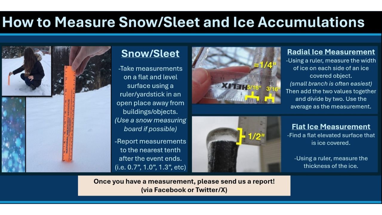
How Residents Are Asked to Measure and Report Accumulations
NWS Shreveport is encouraging residents across the Four-State Region to assist with storm reporting by accurately measuring sleet and ice accumulations. Clear and consistent measurements help meteorologists assess storm severity and improve warning accuracy.
For snow and sleet, residents are advised to:
- Measure on a flat, level surface
- Use a ruler or yardstick in an open area away from buildings
- Report totals to the nearest tenth of an inch after the event ends
For ice accretion, two primary methods are recommended:
- Radial ice measurement: Measure ice thickness on both sides of a small branch, average the values
- Flat ice measurement: Measure ice thickness on a flat, elevated surface using a ruler
Accurate reports can be shared directly with NWS offices through social media or official reporting channels.
Travel and Infrastructure Impacts Expected to Worsen Overnight
With sleet and freezing rain ongoing, officials warn that overnight travel should be avoided unless absolutely necessary. Road conditions may appear passable at first glance but can quickly become treacherous, particularly on bridges and overpasses.
Utility crews are preparing for the possibility of additional outages, especially in areas where ice continues to build on already stressed power lines. Emergency managers urge residents to prepare for potential loss of power and to have flashlights, batteries, and alternative heat sources ready.
What Happens Next as the Storm Continues
Forecast guidance indicates that winter precipitation may persist in parts of the region into Sunday, with additional sleet and freezing rain possible before temperatures eventually rise. Even after precipitation ends, lingering ice may continue to pose risks well into the following day.
Officials emphasize that the impacts of this storm will not end immediately once precipitation stops, as cleanup and recovery could take time across affected communities.
As the Four-State Region remains under the grip of this significant winter storm, staying informed and prepared is critical. For ongoing updates on winter weather, storm totals, and safety information across the region, continue following coverage on ChicagoMusicGuide.com.