
Great Lakes Ice Cover Surges Past Average as Arctic Cold Tightens Grip, Raising Questions for Late-Winter Snow
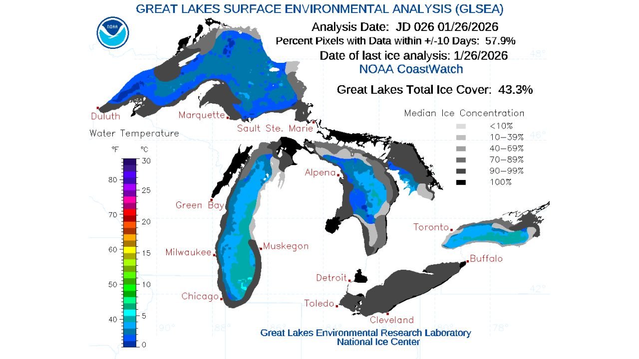
UNITED STATES — A sharp burst of Arctic cold and lighter winds has triggered a rapid expansion of ice across the Great Lakes, pushing total ice cover to 43.3 percent as of January 26, a level now well above the historical average for late January. Data from NOAA shows the lakes freezing at a faster pace than normal, a development that could play a major role in how winter weather unfolds across the Great Lakes region in the weeks ahead.
Ice Cover Jumps Rapidly After Arctic Cold Surge
The latest analysis from the Great Lakes Surface Environmental Analysis (GLSEA) confirms that ice coverage has climbed quickly following several days of bitter cold temperatures and reduced wind-driven wave action. These conditions are ideal for ice formation, allowing newly formed ice to persist instead of breaking apart.
Satellite-based mapping shows significant ice growth across Lake Superior, Lake Michigan, Lake Huron, Lake Erie, and Lake Ontario, with especially notable expansion in nearshore and bay areas. The overall 43.3 percent ice cover marks a clear departure from the slower freeze patterns observed during many recent winters.
Meteorologists note that once ice reaches this level, it tends to reinforce itself, as colder lake surfaces and reduced heat exchange with the atmosphere accelerate additional freezing.
Now Above the Historical Average for Late January
Long-term ice cover records illustrate just how unusual the current pace has become. Historical averages typically show lower ice coverage at this point in the season, with ice building more gradually through February.
The updated NOAA chart tracking Great Lakes average ice cover from 1973 through 2025 shows the 2026 line climbing sharply above the long-term mean, signaling that this winter is evolving differently than many recent years. While not yet near peak seasonal ice levels, the early-season acceleration is significant.
This shift reflects not just one cold day, but a sustained cold pattern, which forecasters expect to continue.
Why Great Lakes Ice Matters for Snow Forecasting
The increase in ice coverage has important implications for lake-effect snow, a defining winter feature for cities like Chicago, Milwaukee, Muskegon, Buffalo, Cleveland, Toledo, and Detroit.
Lake-effect snow thrives on open water, where cold air passing over warmer lakes picks up moisture and heat, fueling snow bands. As ice spreads, that moisture source becomes limited.
With more than 40 percent of the lakes now ice-covered, forecasters expect lake-effect snow potential to gradually decrease, particularly downwind of heavily iced lakes such as Lake Erie and Lake Michigan. This does not eliminate snow entirely, but it can reduce both intensity and frequency of lake-effect events later in winter.
More Ice Likely as Cold Pattern Continues
Forecast guidance points to additional cold days ahead, meaning the Great Lakes are likely to see continued ice growth into early February. If Arctic air remains entrenched and winds stay relatively light, ice coverage could climb well beyond current levels.
Historically, the peak of Great Lakes ice cover often occurs in February, and some winters have seen coverage exceed 70 to 90 percent during extreme cold seasons. While it is too early to determine whether this winter will reach those extremes, the current trend places 2026 on a colder-than-normal trajectory.
Broader Impacts Beyond Snow
Beyond snowfall, expanding ice cover can influence shipping, shoreline stability, and local ecosystems. Ice can reduce wave erosion along coastlines but also complicate commercial navigation if growth accelerates in major shipping lanes.
For communities around the lakes, increasing ice also heightens ice safety concerns, as uneven freezing can create deceptively thin or unstable areas, especially during periods of fluctuating temperatures.
What to Watch Next
Meteorologists will be closely monitoring:
- How quickly ice expands during the next Arctic outbreaks
- Whether ice spreads farther offshore on Lakes Michigan and Huron
- How lake-effect snow patterns adjust as open water shrinks
With winter far from over, the Great Lakes are entering a phase where ice, not open water, may increasingly dominate the weather equation.
As Arctic cold continues shaping winter across the Midwest and Great Lakes region, ice coverage will remain a key factor in forecasting what comes next. For ongoing analysis of winter trends, snow potential, and regional weather impacts, visit ChicagoMusicGuide.com.