
Greenland Blocking Triggers Rising Snow and Storm Threat Across New York, Pennsylvania, New Jersey, and New England
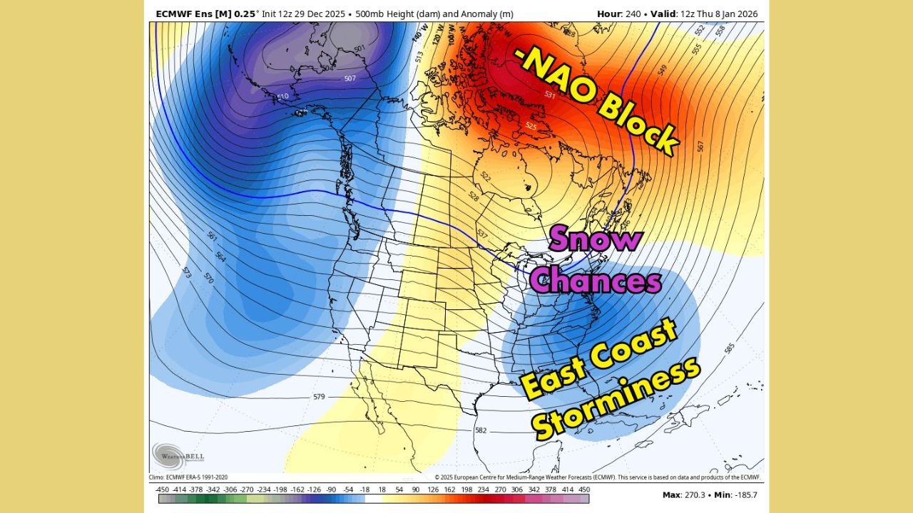
UNITED STATES — Newly analyzed long-range jet stream and upper-air data shows a significant shift toward a more storm-favorable winter pattern for the Northeastern United States, driven by strong Greenland blocking. The setup raises confidence that multiple snow opportunities and periods of stormy weather may begin to emerge across New York, Pennsylvania, New Jersey, and New England as early January approaches.
The data does not point to a single guaranteed snowstorm, but instead highlights a pattern change that historically increases the frequency and intensity of winter systems across the region.
Greenland Blocking Establishes a Negative NAO Pattern
The most dominant feature in the data is a pronounced Greenland block, a hallmark of a negative North Atlantic Oscillation (−NAO). This atmospheric configuration slows the jet stream across the North Atlantic, preventing weather systems from moving quickly out to sea.
When Greenland blocking strengthens, colder air is more easily retained over the northeastern United States, while storm systems are forced to track closer to the coast. This combination significantly raises the odds of snow-producing systems rather than fast-moving rain events.
Jet Stream Alignment Favors Northeast Snow Potential
The jet stream pattern shows a clear trough positioned over the eastern United States, with energy diving southeastward toward the Northeast. This alignment is a classic signal for coastal storm development, especially when paired with blocking to the north.
As systems approach the East Coast, resistance from the Greenland block can cause storms to slow or intensify, increasing the chance for wintry precipitation inland. Interior sections of the Northeast are especially favored in this type of setup.
Highest Snow Signal Focused on Interior Northeast States
Based on the data, the strongest snow potential appears focused across:
- Upstate New York
- Interior Pennsylvania
- Northern New Jersey
- Much of New England
These areas are positioned closest to the cold air supply, making it more likely that precipitation falls as snow rather than rain. While coastal areas may initially see mixed precipitation, even modest shifts in storm track could bring colder outcomes inland.
East Coast Storminess Extends Beyond Snow
Farther south along the Mid-Atlantic and Southeast coast, the data supports increased storminess, even if snow is less certain in those areas. Stronger systems in this pattern can produce heavy rain, gusty winds, and rapid temperature drops following frontal passages.
This broader storm signal reflects an active jet stream, not a quiet winter regime, suggesting multiple weather systems may affect the East Coast over a short time span.
Why This Pattern Deserves Attention
Greenland blocking patterns are important because they tend to persist, often lasting one to two weeks or longer. Once established, they create repeated opportunities for winter weather rather than isolated events.
For residents, travelers, and event planners across New York, Pennsylvania, New Jersey, and New England, this means an increased need to monitor forecasts closely as timing and impacts can change quickly once storms begin to organize.
What Comes Next
While it is too early to determine exact snowfall totals or pinpoint specific storm dates, the large-scale signal is clear: the Northeast is entering a more winter-favorable pattern with rising snow and storm chances. Additional clarity will emerge as individual systems develop within this broader setup.
As this evolving pattern continues to take shape, ChicagoMusicGuide.com will keep tracking how Northeast winter weather may affect travel, touring schedules, and regional planning across the eastern United States.