
Gulf Coast Braces for Multi-Day Severe Weather Threat as Robust Southern Trough Targets Texas and Louisiana Late Friday Into Saturday
HOUSTON, TEXAS — A strengthening and increasingly organized storm system is setting the stage for a multi-day severe weather threat across the Gulf Coast states, beginning late Friday and peaking Saturday. Forecast guidance now shows growing agreement between major model ensembles that a robust upper-level trough will track into the southern United States, allowing a surface low to develop and deepen ahead of it.
While some uncertainty remains in the exact position of the surface low and how far north Gulf moisture advances, the signal for at least a corridor of severe weather is becoming clearer — particularly from east Texas into Louisiana on Saturday.
Models Agree on Strong Upper-Level Energy
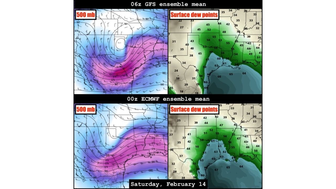
Both the GFS ensemble mean and the ECMWF ensemble mean show a pronounced 500mb trough digging into the southern Plains and Lower Mississippi Valley. This upper-level configuration supports large-scale lift and strengthens wind fields aloft — a key ingredient for organized thunderstorms.
At the surface, dew point projections indicate a substantial northward surge of Gulf moisture. Values in the upper 50s to low 60s appear likely across southeast Texas, southern Louisiana, Mississippi, and Alabama, creating a humid and unstable air mass ahead of the advancing system.
This combination of strong upper-level dynamics and increasing surface moisture points toward overlapping thermodynamics and kinematics — the classic ingredients needed for severe storm development.
East Texas Into Louisiana Highlighted for Saturday
The most concentrated severe potential currently appears focused across east Texas into Louisiana, especially during the Saturday timeframe. As the surface low deepens and tracks eastward, a corridor of instability is expected to align with strengthening wind shear.
While widespread outbreak conditions are not guaranteed, the environment appears supportive of:
- Damaging wind gusts
- Isolated tornado potential
- Heavy rainfall
- Embedded stronger storm cells within a larger rain shield
Storms may initially organize in western portions of Texas late Friday before shifting eastward. Elevated thunderstorms capable of producing hail are possible across west Texas late Friday into Saturday morning, particularly where colder air aloft overlaps strengthening lift.
Severe Threat Could Extend Into the Southeast
As the system continues east, the severe weather risk may extend into Mississippi, Alabama, and parts of Georgia on Sunday. The exact intensity and coverage will depend on how quickly the surface low tracks northeast and how efficiently moisture spreads inland.
Even if the most intense dynamics remain focused near the Gulf Coast, areas farther east could still see strong thunderstorms as the broader rain shield sweeps through.
Position of Surface Low Remains Key Variable
Despite improved agreement on the large-scale pattern, uncertainty remains regarding the exact placement of the surface low. A slight northward shift would allow deeper moisture penetration inland, increasing severe potential farther north. A more southern track would confine the strongest storms closer to the immediate Gulf Coast.
This detail will determine how far north the most unstable air mass can advance before frontal passage.
What Residents Should Expect
Late Friday through Saturday appears to be the most active window across Texas and Louisiana, with potential continuation into Sunday across the broader Southeast.
Residents in the following areas should monitor updates closely:
- Houston, Beaumont, and eastern Texas communities
- Lake Charles, Baton Rouge, and southern Louisiana
- Portions of Mississippi and Alabama
Heavy rainfall is also expected, meaning localized flooding could accompany stronger storms in some locations.
Dynamic Setup Worth Monitoring
The developing system features strong upper-level forcing, increasing Gulf moisture, and a deepening surface low — all elements that suggest this is not a weak or disorganized event.
Confidence is growing that at least some level of severe weather will occur along the Gulf Coast corridor. Exact intensity and coverage will become clearer as high-resolution guidance refines storm structure and track over the next 24–48 hours.
For ongoing updates on major weather systems impacting travel, concerts, and weekend plans across the country, stay connected with ChicagoMusicGuide.com for the latest coverage.