
Illinois and Missouri Face Light Snow Thursday Night as NWS St. Louis Warns of Slick Bridges Into Friday Morning
ILLINOIS – A quick burst of light snow is expected to develop across parts of the St. Louis region and nearby Illinois counties Thursday evening, with the best chance for measurable accumulation east of the Mississippi River and impacts lingering into very early Friday morning, according to an update from the National Weather Service office in St. Louis.
Most communities are projected to pick up an inch or less, but forecasters say localized pockets could reach 1–2 inches in a worst-case scenario. Even minor totals could still create isolated slick spots, especially where pavement cools quickly after sunset.
What the forecast is showing right now
The latest briefing highlights a narrow window for snow:
- Timing: Thursday evening through very early Friday morning
- Temperatures: Mid-20s to low-30s Thursday evening, then low-30s Friday morning
- Typical totals: Dusting to 1 inch
- Localized higher totals: Up to 2 inches in the most favored spots
The overall message is that this is not shaping up like a major storm for most towns — but it’s the kind of setup where a light coating can still cause problems if it lands during peak travel hours or when roads are untreated.
Where impacts look most likely
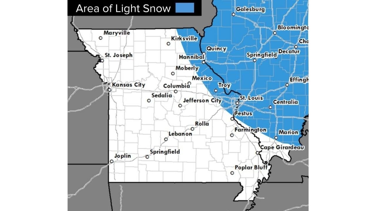
The highlighted impact zone favors areas east of the Mississippi, including a broad swath of Illinois communities in and around the St. Louis forecast area. Cities and corridors shown within the light-snow shading include locations such as:
- Quincy and Hannibal area
- Galesburg
- Bloomington
- Springfield and Decatur
- Effingham
- Centralia and Marion
- The Metro East near the St. Louis region
While the snow signal is focused most strongly on the Illinois side, drivers in eastern Missouri near the St. Louis metro should also stay alert for changing road conditions depending on where bands set up.
Why “light snow” can still be a real problem
Even when totals are small, the impacts can be outsized if the snow falls at the wrong time or if temperatures hover near freezing:
- Bridges and overpasses cool faster than regular roads and can turn slick first.
- A thin coating is enough to reduce traction, especially on untreated surfaces.
- Brief bursts of snow can lead to quick visibility drops, particularly under heavier showers.
That combination is why the NWS briefing emphasizes isolated slick spots late Thursday night into Friday morning, with special concern for elevated roadways.
What to do if you’re driving Thursday night or early Friday
If you have to be out during the window when snow is expected, a few basic steps can reduce the risk:
- Slow down earlier than you think you need to, especially on ramps and bridges.
- Increase following distance and avoid sudden braking.
- Watch for patchy slick spots even if roads look mostly wet.
- Give yourself extra time for the Friday morning commute if you’re in the highlighted zone.
What happens next
This setup is expected to move through fairly quickly, with most of the action confined to the Thursday night–early Friday window. The main uncertainty is how efficiently snow bands develop and where they focus — which is what determines whether most places stay under an inch or whether a few pockets sneak closer to 2 inches.
Have you noticed roads getting slick in your area during “light snow” events like this? Share what you’re seeing — and keep following ChicagoMusicGuide.com for fast, plain-English weather updates that help you plan your week.