
Illinois, Indiana, Ohio, Georgia, and the Southeast Face Late-January Cold Surge as Snow Threats Remain Limited but Monitored
CHICAGO — A broad late-January shift toward colder weather is taking shape across large parts of the United States, with forecast guidance pointing to a significant cold outbreak between January 26 and January 29 that could spill from the northern Plains into the Midwest, Ohio Valley, Southeast, and Northeast. While snow potential exists in select regions, meteorologists emphasize that cold does not automatically equal a major snowstorm, and impacts will vary sharply by state.
A Widespread Cold Pattern Is Becoming More Likely
Long-range guidance shows growing confidence in a deep Arctic intrusion driven by a strongly negative West Pacific Oscillation (WPO), Arctic Oscillation (AO), and North Atlantic Oscillation (NAO)—a combination that historically favors cold air draining southward into the central and eastern United States.
Temperature probability maps centered around January 27 show below-normal temperatures favored across Illinois, Indiana, Ohio, Michigan, Pennsylvania, Georgia, and much of the Southeast, while the western U.S. trends warmer. This pattern supports repeated cold shots rather than a single brief event.
For Chicago and the Midwest, this setup increases the likelihood of persistent cold, but not necessarily heavy snow unless moisture aligns correctly.
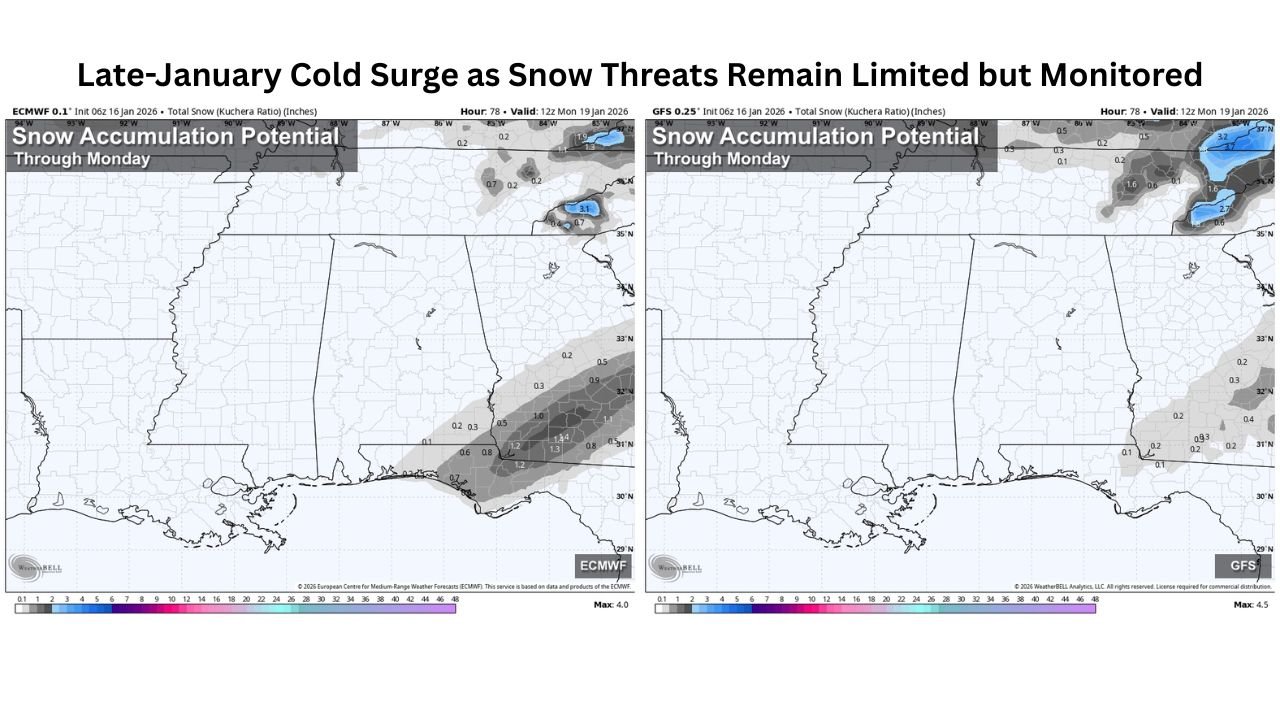
Midwest and Great Lakes: Cold Dominates, Snow Depends on Timing
Across Illinois, Indiana, Ohio, and Michigan, ensemble guidance shows strong confidence in colder-than-average conditions late in the month. However, storm chances remain conditional.
Forecast models suggest:
- Cold air arrives decisively
- Moisture availability is less certain
- Storm tracks could favor areas just south or east of the region
This means snow is possible, but no high-confidence major winter storm signal is present yet for the Midwest. Forecasters note that storm details remain unresolved and will depend on how southern systems interact with the advancing cold.
Georgia and the Southeast: Snow Chances Exist, But Accumulation Is Limited
In central and east Georgia, including areas along and south of the I-85 corridor, confidence has increased for light snow potential late Saturday night into Sunday ahead of the larger cold outbreak.
Current expectations show:
- Snow totals generally between 0.5 and 1.5 inches
- A very low chance of localized higher amounts
- Rain changing briefly to snow as colder air filters in
Road temperatures are expected to remain above freezing in many areas, limiting travel impacts. Forecast confidence is higher here because models are in strong agreement, but accumulation potential remains modest.
Alabama and the Gulf Coast: Wet Roads, Not a Winter Storm
For southern Alabama, including areas near Dothan, guidance shows rain may briefly mix with light snow early Sunday as cold air pushes south. However:
- Temperatures are expected to remain in the mid-30s
- Accumulation is unlikely
- Roads should remain wet, not icy
Meteorologists stress that meaningful impacts are not expected, despite online speculation suggesting otherwise.
Why Many “Snow Maps” Are Being Overstated
Forecasters are pushing back against exaggerated snowfall graphics circulating on social media. While cold air is real and confidence is high, numerical weather models often overestimate snow when moisture exits before temperatures fall far enough.
Experienced meteorologists emphasize:
- Cold and precipitation must overlap precisely
- Model bias can exaggerate snow totals days in advance
- Reliable forecasts improve closer to the event window
This is why official guidance continues to frame the situation as “monitoring” rather than “warning.”
What Comes Next
Looking ahead:
- Cold confidence is high across the Midwest, Southeast, and Northeast
- Snow confidence is moderate to low, depending on location
- Additional storm opportunities may emerge later in January or early February
For snow lovers, winter is far from over—but late January’s story appears to be dominated more by cold than by widespread disruptive snow.
Stay connected with ChicagoMusicGuide.com for continued winter weather updates, regional breakdowns, and clear explanations as late-January forecasts evolve.