
Illinois, Missouri, Pennsylvania, Maryland, the Carolinas, and the Midwest Face Light Snow, Rain Mix, and an Arctic Blast This Weekend
CHICAGO, ILLINOIS — A complex and wide-reaching winter weather pattern is unfolding across the United States this weekend, bringing light snow chances to Illinois and Missouri, coating-level snowfall potential across Pennsylvania and Maryland, rain-snow mix concerns in the Carolinas, and a dangerous Arctic blast targeting the Midwest with life-threatening cold by early next week.
While this is not shaping up to be a blockbuster snowstorm, multiple rounds of winter weather could still create slick travel conditions, brief accumulations, and sharply colder air, especially as temperatures crash behind the system.
Illinois and Missouri: Two Rounds of Light Snow With Slick Spots Possible
Forecast data from the St. Louis region indicates two separate rounds of light snow affecting parts of eastern Missouri and southern Illinois.
The first round arrives Thursday evening, spreading from northwest to southeast and lasting only a few hours. A second round is expected Friday afternoon into Friday evening. Each round carries the potential for up to one-half inch of snowfall, with the highest chance for accumulation along and east of the Mississippi River.
While totals remain modest, slick spots are likely, particularly late at night and early Friday morning, when colder temperatures allow untreated roads, bridges, and overpasses to freeze.
Pennsylvania and Maryland: Saturday Snow May Bring a Coating to 1 Inch
Attention then shifts eastward to the Mid-Atlantic, where Saturday snow potential is becoming increasingly noticeable across Pennsylvania, Maryland, and the Delmarva region.
Based on the latest ECMWF (European) model guidance, much of the region is in play for a light accumulation, generally a coating up to 1 inch. Some localized banding may allow isolated spots in central and eastern Pennsylvania and south or east of Annapolis to briefly reach the 1-inch mark.
Snow is expected to be light but steady at times, especially Saturday afternoon into early evening. While impacts should remain limited, roads could become briefly slick, particularly during heavier bursts.
The Carolinas: Rain Dominates, but Snow May Mix In Inland
In North Carolina and South Carolina, colder air remains the biggest question mark.
Current data suggests that areas between Interstate 95 and Interstate 85 have the best chance to see snowflakes mix in, mainly Sunday morning into Sunday afternoon. East of I-95, including much of the coastal plain and Pee Dee region, light rain is the most likely outcome, though wet snow or sleet may briefly mix in if colder air arrives faster than expected.
Accumulations, if they occur at all, are expected to be minimal and confined mainly west of I-95, where ground temperatures and marginal air temperatures may still limit sticking.
Florida Panhandle and North Florida: Flurries Possible, Slush Not Ruled Out
In a rare southern twist, North Florida, including Tallahassee, could see snowflakes mix in on Sunday.
Forecast guidance shows a narrow window where cold air overlaps lingering moisture, allowing flurries or light snow showers. While widespread accumulation is unlikely, localized slushy spots — potentially up to around 2 inches in extreme cases — cannot be fully ruled out, especially under heavier showers.
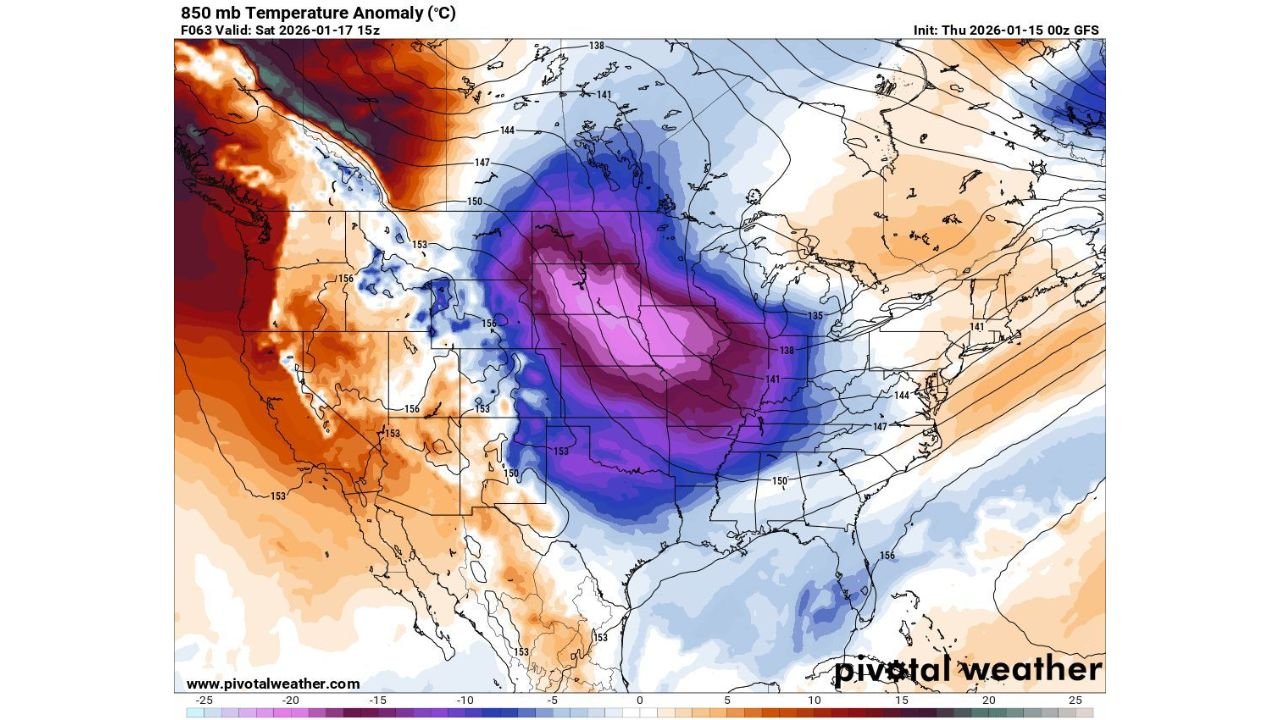
Midwest Arctic Blast: Dangerous Cold Follows the System
Behind this system, a powerful Arctic air mass will surge southward, slamming the Midwest late Sunday into Monday.
Temperatures are forecast to plunge rapidly, with wind chills as low as –30°F possible across parts of Illinois, Iowa, Minnesota, Wisconsin, and neighboring states by Monday morning. This level of cold poses serious risks, including frostbite within minutes and dangerous conditions for anyone without adequate heating.
Residents are urged to prepare now, checking winter safety plans, protecting pets, and ensuring vulnerable individuals have access to warmth.
What This Means Overall
This weekend’s weather setup favors many small impacts rather than one major storm:
- Light snow and slick spots in Illinois and Missouri
- Coating-level snow chances in Pennsylvania and Maryland
- Rain with occasional snow mixing in across the Carolinas
- Flurries possible as far south as North Florida
- A significant Arctic blast bringing extreme cold to the Midwest
Confidence remains moderate to low on exact snowfall totals in many areas, especially in the Southeast, and forecast updates are likely as colder air timing becomes clearer.
As always, stay weather-aware, monitor local updates, and plan ahead for changing conditions. For continued coverage of winter weather impacts and how they may affect travel and events, keep checking back with ChicagoMusicGuide.com.