
Indiana, Ohio, Kentucky, Tennessee, Alabama, and Georgia Hit by 40–50 MPH Wind Gusts From Fast-Moving Storm Line
Indiana — A fast-moving line of storms powered by strong upper-level dynamics marched across the Midwest and Deep South on Wednesday night, producing widespread 40–50 mph wind gusts and creating hazardous travel and power outage risks across multiple states. Radar imagery showed an extensive band of heavy rain and embedded thunderstorms stretching from Indiana and Ohio down through Kentucky, Tennessee, Alabama, and Georgia, with strong gradient winds developing well outside the storm cores.
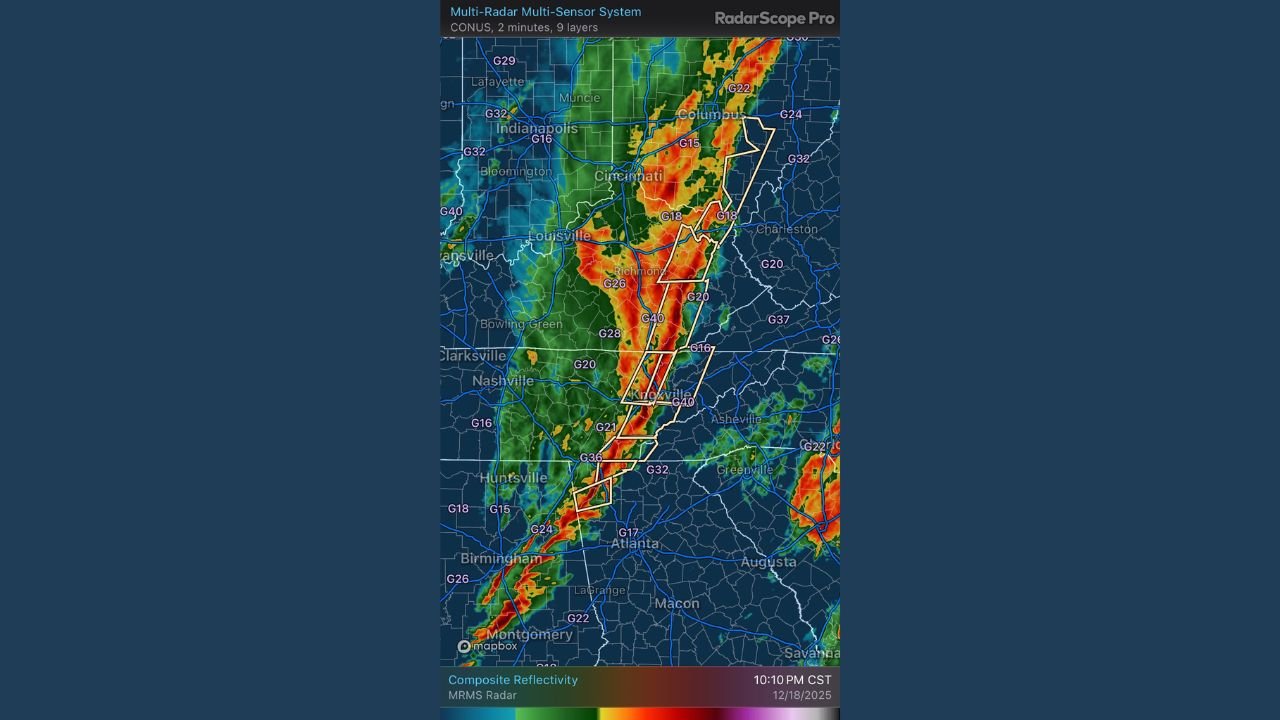
Widespread Wind Gusts Reaching 40–50 MPH Across the Midwest
According to the radar data, the storm line pushed eastward across Indiana, Illinois, and Ohio, producing wind gusts frequently measured in the G20–G40 range. Even areas not directly beneath thunderstorm cells experienced strong winds, with gradient gusts of 30–40 mph spreading across the broader region.
Communities including Indianapolis, Bloomington, Cincinnati, Louisville, and Columbus were impacted as the line rapidly intensified, despite limited atmospheric instability. Meteorologists noted that the event was driven primarily by robust dynamic forcing rather than traditional thunderstorm energy.
Deep South States Experience Strongest Portions of the Storm Line
Radar imagery highlights severe wind signatures and heavy rainfall across Tennessee, northern Alabama, and western Georgia, where embedded segments of the line displayed the strongest gusts.
Cities and regions most affected include:
- Nashville, TN – Gusts pushing into the 40 mph range
- Huntsville and Birmingham, AL – Frequent G20–G40 wind readings
- Atlanta and northwest Georgia – Strong winds advancing southward through the evening
Several yellow-boxed polygons on radar indicate areas under severe thunderstorm warnings, consistent with damaging wind potential.
Storm Line Continues Accelerating Toward the Northeast
Forecasters warn that the same strong dynamics responsible for the storm line across the Midwest and South will continue into Thursday, pushing the wind threat toward:
- Western Pennsylvania
- West Virginia
- New York State
- New Jersey and southern New England
This transition is expected to bring another round of strong non-storm winds, with many locations projected to experience 30–40 mph gusts, even outside precipitation.
Why the Event Is Significant
Unlike many severe weather episodes, this one featured:
- Minimal instability
- Very strong upper-level jet support
- Fast storm motion
- Large-scale pressure gradients
This combination allowed the line of storms to maintain intensity across hundreds of miles while generating a widespread footprint of damaging winds.
What Residents Should Do
With the storm line continuing eastward, authorities recommend:
- Secure outdoor decorations and loose objects
- Prepare for isolated power outages
- Use caution during travel due to sudden crosswinds
- Stay alert for late-night and early-morning weather updates
More Updates Coming
Chicago Music Guide Weather will continue tracking the evolution of this storm system as it moves into the Northeast. Check back for additional updates, forecast adjustments, and new wind impact maps as they become available.