
Late-December Temperature Shift Expected Across the Eastern United States as Forecast Models Trend 4–8°F Colder
ILLINOIS — A major temperature adjustment is now showing up across multiple forecast models, pointing to a notably colder period between Christmas and New Year for the Eastern United States. New ensemble runs from the ECMWF (Euro) model reveal widespread 4–8°F colder changes compared to previous runs, signaling a potentially meaningful pattern shift as December closes.
Meteorologists note that while 1–2° run-to-run adjustments in ensemble systems are normal, the magnitude of the latest change indicates that models were not handling the transition pattern well earlier in the month. The Euro is not alone—other global models also trended colder overnight, adding confidence that the warming pattern dominating early December may be coming to an end.
A Clearer Signal Emerges in a Complex Seasonal Pattern
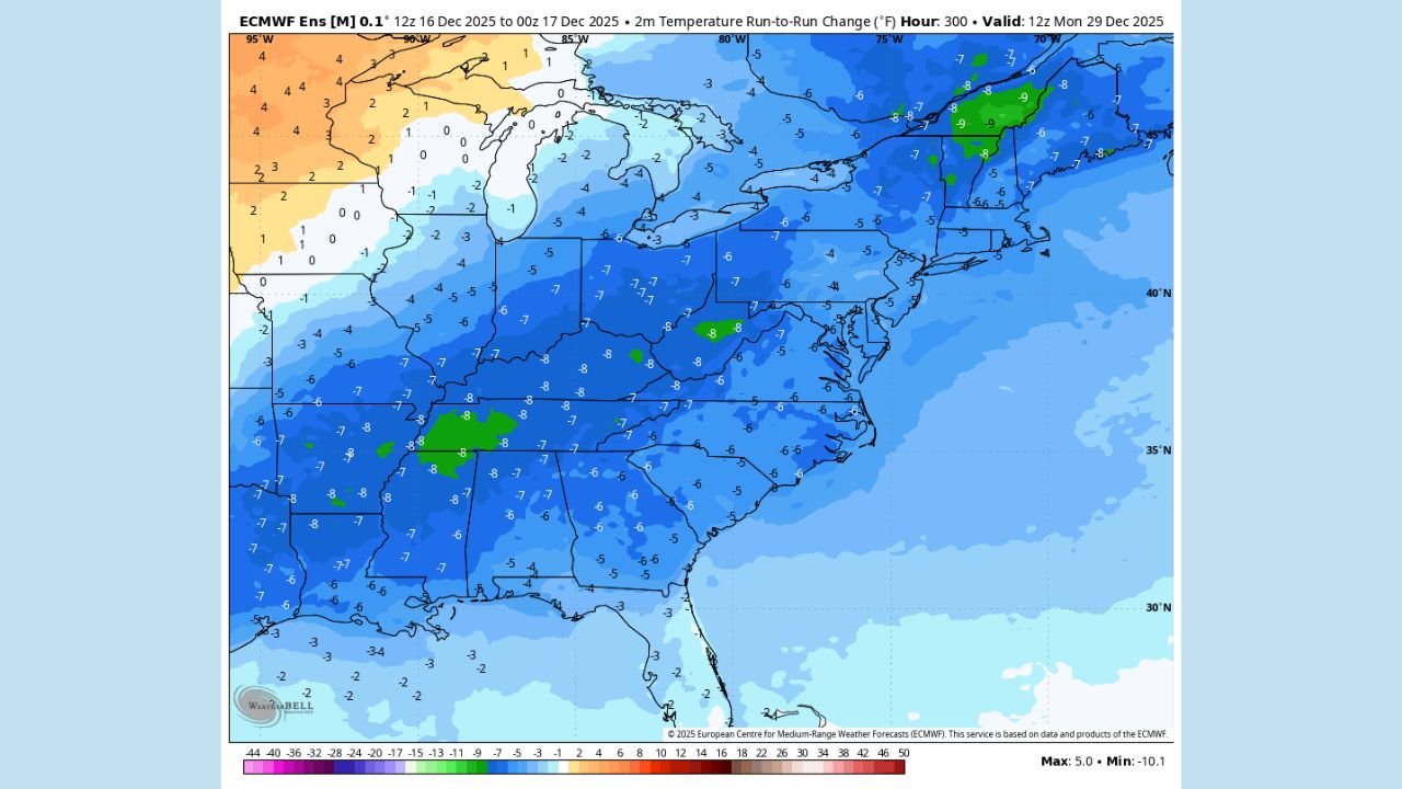
The latest imagery shows a broad area of colder adjustments extending from the Midwest through the Ohio Valley, Appalachians, Mid-Atlantic, and into the Northeast. Most locations are now running 5–8°F colder than previous ensemble expectations.
Forecasters emphasize that seasonal transitions—especially between autumn and winter—are among the most difficult periods for global models to resolve. With atmospheric patterns shifting and jet streams reorganizing, model performance often becomes erratic.
This is why meteorologists are leaning heavily on global observations rather than single-run model output. And in this case, the observational trends appear to support the colder shift now showing up in ensemble data.
Where the Biggest Temperature Drops Are Expected
Based on the ECMWF ensemble temperature-change graphic:
- Illinois, Indiana, Missouri, and Kentucky show widespread 6–8°F colder projections.
- Tennessee, Arkansas, Mississippi, Alabama, and Georgia also trend 5–8°F colder region-wide.
- Ohio, Pennsylvania, West Virginia, Virginia, and North Carolina display a consistent 5–7°F colder shift.
- The Northeast shows mixed signals—some areas of New York and New England still trend slightly warmer, though most locations lean colder.
These changes reflect temperature expectations for December 29, 2025, representing the last portion of the holiday period.
What This Means for the Holiday Stretch
While this is not a snowfall forecast, the colder shift increases confidence that:
- The mild pattern dominating early December will weaken.
- A storm track shift may place the northern tier and Northeast into a more active, storm-friendly regime.
- Colder air will likely be more available for any late-December or early-January systems.
Still, forecasters caution that the degree of cold and its duration remain uncertain. Even with improved consistency across models, winter patterns can evolve rapidly as the jet stream reshapes.
Why This Trend Matters
Meteorologists highlight that during transitional periods—such as the ramp-up to winter—global models often struggle. The 4–8°F downward shift seen in the latest data underscores:
- The value of ensemble guidance over single deterministic runs
- The importance of real-world atmospheric observations
- The need for cautious interpretation before major holiday travel windows
With millions planning long-distance travel between December 23 and January 2, even moderate temperature changes can influence storm behavior along major corridors.
More updates are expected as additional ensemble cycles arrive and the pattern continues to clarify in the days ahead.
ChicagoMusicGuide.com will continue tracking late-December temperature trends and their potential impacts on holiday travel.