
Light Snow Targets Western and Eastern New England Monday Afternoon, Bringing 1–2 Inches Before Midnight
NEW ENGLAND — A light but widespread snowfall event is expected to move across western and eastern New England on Monday afternoon and evening, with snow developing first in the west before spreading east and tapering off before midnight, according to the latest forecast data.
The setup points to minor accumulations for most communities, but timing during the afternoon and evening commute could still create localized travel slowdowns, especially inland.
Snow Timing: West First, East Later
Forecast guidance shows snow developing between 1 p.m. and 3 p.m. in western New England, including western Massachusetts and parts of northern Connecticut. Farther east, including central and eastern Massachusetts, Rhode Island, and coastal New England, snow is expected to arrive between 3 p.m. and 6 p.m.
Snowfall intensity should remain light overall, with the system tapering off before midnight as drier air works in from the west.
Expected Snow Amounts Across the Region
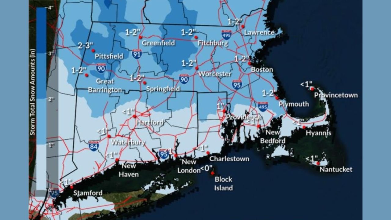
Most inland areas of New England are expected to see 1 to 2 inches of snowfall, with locally higher totals possible in parts of western Massachusetts, where slightly stronger forcing may briefly enhance snowfall rates.
Closer to the south coast, including portions of Rhode Island, southeastern Massachusetts, Cape Cod, and coastal Connecticut, warmer air near the surface may limit accumulation. In these areas, totals are expected to range from a coating up to around 1 inch, with some spots seeing little accumulation on paved surfaces.
Evening Commute Impacts Likely
While this is not a high-impact winter storm, timing is the primary concern. Snow falling during peak travel hours may lead to slick roads and reduced visibility, particularly across western New England where snow begins earlier in the afternoon.
Road temperatures and traffic conditions will ultimately determine how quickly snow accumulates, but brief travel delays are possible even with modest totals.
What This System Is — and Isn’t
This event is not expected to produce heavy snow, strong winds, or hazardous conditions overnight. There are no signals for rapid intensification or coastal enhancement, and snow should steadily weaken as the evening progresses.
However, the forecast confidence is high that most of the region will see measurable snow, making this a classic low-accumulation, high-coverage winter weather setup.
Residents are encouraged to allow extra travel time Monday afternoon and evening and to stay updated in case minor adjustments to timing or totals are made closer to the event.
Have you seen snow start earlier than expected in your area, or do you think this one underperforms? Share your local observations and stay connected with ChicagoMusicGuide.com for ongoing weather updates and regional forecasts.