
Major Ice Storm Signal Emerges for Texas, Arkansas, Tennessee, Mississippi, Alabama, Georgia and the Carolinas Late January
CHICAGO, ILLINOIS — A potentially high-impact winter storm is beginning to take shape on long-range and medium-range guidance, with a significant ice storm increasingly likely somewhere across the southern United States between Friday, January 23, and Sunday, January 25. While exact locations are still uncertain, the overall setup is classic, well-defined, and increasingly concerning, particularly for parts of Texas, Arkansas, Tennessee, Mississippi, Alabama, Georgia, and the Carolinas.
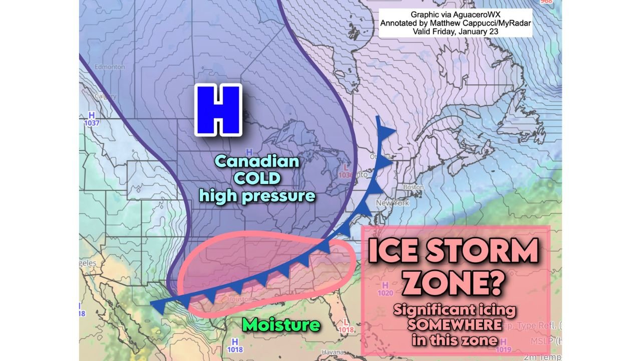
Meteorological guidance from the ECMWF (European model) continues to advertise a strong Canadian high-pressure system pressing southward, delivering a shallow but very cold air mass into the central and eastern U.S. At the same time, deep Gulf moisture is forecast to surge northward, overrunning the entrenched cold surface layer — a textbook recipe for widespread freezing rain and dangerous ice accretion.
Why This Pattern Is Raising Red Flags
The developing setup checks nearly every box forecasters watch for when assessing major ice storm potential:
- Strong Canadian high pressure forcing subfreezing air south into the Lower 48
- Shallow cold air trapped near the surface, difficult to scour out
- Warm air aloft surging north from the Gulf, allowing precipitation to fall as rain
- Liquid rain freezing on contact, leading to ice accumulation rather than snow
Model guidance consistently shows a tight thermal gradient, with surface temperatures well below freezing north of the Gulf Coast while warmer air rides overhead. This creates an environment where freezing rain dominates, especially near the transition zone between deep cold air and milder southern air.
Ice Accumulation Could Become Severe in Narrow Corridor
One of the most concerning signals in recent runs is the potential for a narrow but intense band of icing, rather than a broad, light event. In similar historical setups, this type of storm has produced half an inch of ice or more in localized areas — enough to cause tree damage, power outages, and impassable roads.
If the core ice band verifies:
- Branches and trees may snap under ice load
- Power lines could fail, leading to prolonged outages
- Travel could become impossible for days in the hardest-hit locations
- Emergency response may be delayed due to icy road conditions
Travel during a significant ice storm is not just difficult — it is often impossible, particularly during peak icing.
Where the Highest Risk Currently Appears
At this range, forecasters are not locking down specific cities, but the broader risk zone stretches from eastern Texas through the Deep South and into parts of the Southeast and southern Mid-Atlantic. Areas currently under heightened attention include:
- Eastern Texas and southern Arkansas
- Northern Louisiana and Mississippi
- Tennessee Valley regions
- Northern Alabama and Georgia
- Portions of South Carolina and North Carolina
Small shifts north or south in the cold air boundary will dramatically change who sees snow, sleet, freezing rain, or plain rain, which is why confidence in exact placement remains limited for now.
Temperature Profiles Support Ice Over Snow for Many
ECMWF temperature guidance shows surface readings well below freezing across much of the interior Southeast, while temperatures just a few thousand feet above ground climb above freezing. This vertical temperature mismatch heavily favors freezing rain, especially in areas south of the deeper Arctic air core.
Snow ratios could become very high farther north where colder air is deeper, but ice remains the primary concern across the southern tier.
Timeline: What to Watch Over the Coming Days
- 7–10 days out: Pattern recognition phase — this is where we are now
- 5–7 days out: Confidence in storm existence increases or decreases
- 3–5 days out: Precipitation type and timing become clearer
- 1–3 days out: Specific impacts, ice totals, and warnings can be issued
Right now, this event firmly sits in the “possible but credible” category. Trends over the next several days will be critical.
What Residents in the Risk Zone Should Do Now
While it is too early for panic, awareness is warranted, especially in areas highlighted for potential icing. Residents should consider:
- Monitoring forecast updates daily
- Preparing for potential power outages
- Stocking basic non-perishable supplies
- Avoiding unnecessary travel if ice warnings are issued later
Bottom Line
This is not hype, but it is also not a finalized forecast. The atmospheric ingredients for a significant southern ice storm are coming together, and history shows setups like this can escalate quickly once the forecast window tightens.
An active winter pattern remains locked in, meaning additional storms are likely even beyond this one. Some systems will underperform, others may exceed expectations — and this one is worth watching closely.
Stay tuned, stay flexible, and remember: long-range forecasts are about awareness, not alarms.