
Maryland Braces for Weekend Winter Storm as Advisories and Warnings Issued; Snowfall of 1–8 Inches Expected Across the State
MARYLAND — A winter storm is expected to sweep across Maryland from Saturday evening into Sunday morning, bringing widespread snowfall, slippery travel, and the first significant winter weather of the season to much of the state.
The National Weather Service has issued Winter Storm Warnings for far western Maryland and Winter Weather Advisories across central and eastern Maryland, including Baltimore, Annapolis, and the Washington, D.C. metro region.
Winter Storm Warning in Western Maryland: 4 to 8 Inches of Snow
Garrett County and parts of far western Maryland are under a Winter Storm Warning from 1 PM Saturday to 4 AM Sunday.
Forecast impacts include:
- 4 to 8 inches of snow
- Steady snowfall developing Saturday afternoon
- Hazardous road conditions in the mountains
- Reduced visibility, especially after dark
This area sits closest to the storm’s deeper moisture and strongest lift, placing it in the highest snowfall zone for Maryland.
Winter Weather Advisory for Central and Eastern Maryland
A Winter Weather Advisory is in effect from 8 PM Saturday to 7 AM Sunday, covering:
- Baltimore City and County
- Washington, D.C. region
- Annapolis and Anne Arundel County
- Harford, Cecil, and Carroll counties
- Southern Maryland into the Lower Eastern Shore
Expected snowfall amounts:
- 1″ to 3″ for most areas
- Localized spots reaching 5″, especially northeast of Baltimore toward Bel Air, Elkton, and the northern Chesapeake region
This is consistent with snowfall maps showing a broad 1–3 inch zone, with enhanced bands developing across northern Maryland as the storm pivots through.
Storm Setup: Bitter Cold, Advancing Snow, and Overnight Impacts
Saturday morning’s surface weather map shows:
- Bitter cold air diving southeast from the Upper Midwest
- A broad area of snow stretching from St. Louis to Detroit
- A fast-moving system that will slide into Maryland late Saturday
The incoming cold ensures that all precipitation will fall as snow, with temperatures supportive of accumulation even on treated surfaces after sunset.
Timing: Snow Arrives Saturday Night and Peaks Early Sunday
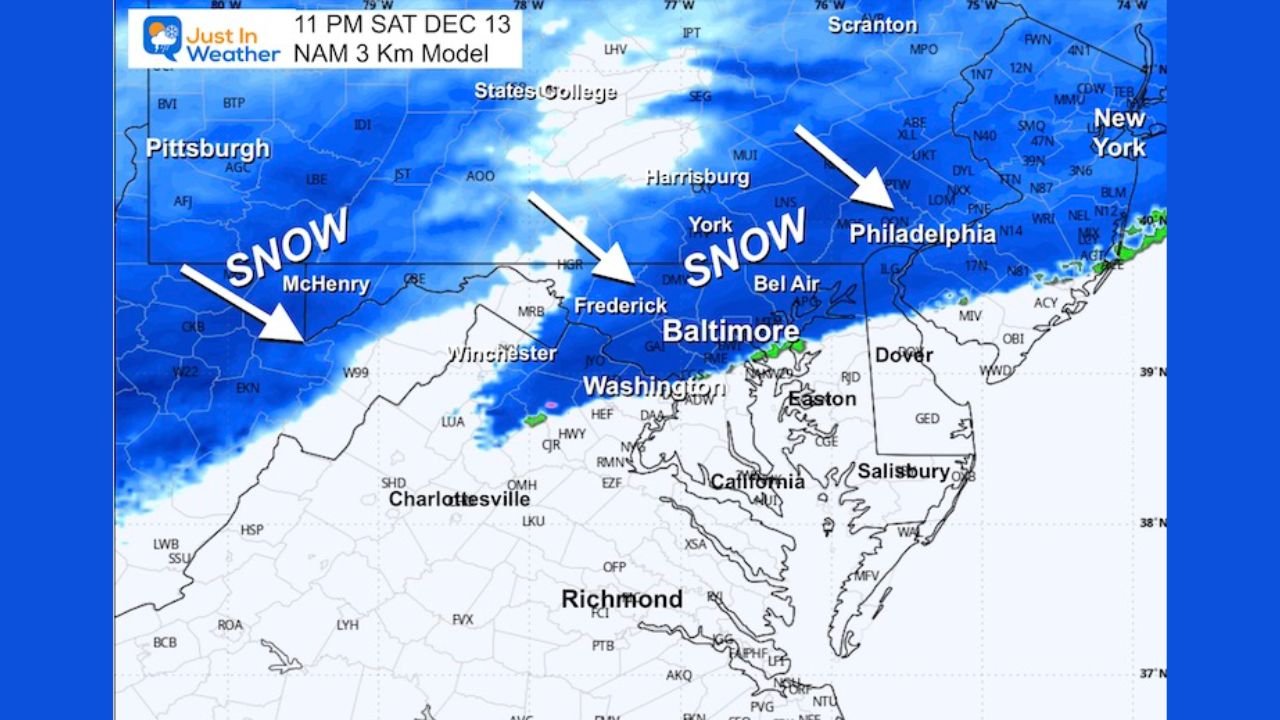
Based on the NAM 3 km model:
- Snow reaches western Maryland by late afternoon
- Light snow spreads into Frederick, Baltimore, and Washington by evening
- Heaviest snow falls between 9 PM and 3 AM
- Snow tapers off from west to east before sunrise Sunday
The model highlights a solid band of snow stretching across Pennsylvania, Maryland, and into New Jersey, with the most consistent snowfall positioned from Frederick to Baltimore to Philadelphia.
Snowfall Expectations by Region
Western Maryland (Warning Area)
- 4″ to 8″
- Greatest impacts, especially near Deep Creek Lake and Hagerstown’s western edge
Central Maryland (Baltimore–Washington Corridor)
- 1″ to 3″
- Isolated pockets near 2″ to 4″ if stronger bands develop
- Some higher spots northeast of Baltimore
Southern Maryland & Lower Eastern Shore
- Coating to 1″, with localized areas up to 2″ closer to Annapolis and Easton
Northern Maryland into Southeastern Pennsylvania
- 2″ to 4″, with enhanced potential for higher totals east of York and Lancaster
Travel Impacts
Drivers should anticipate:
- Slippery roads overnight
- Reduced visibility during heavier bursts
- Slow travel on I-70, I-95, and the Baltimore Beltway
- Early Sunday morning hazards before crews can fully treat roads
Because the storm peaks overnight, many of the worst travel conditions will occur while most people are off the roads — but early morning commuters should remain cautious.
First Widespread Snow of the Season for Many Areas
For central and eastern Maryland, this is shaping up to be the first measurable snowfall of the season, arriving earlier than typical for some communities. Even with modest totals, the combination of cold ground temperatures and nighttime timing will enhance impacts.
Chicagomusicguide.com will continue monitoring the storm and provide updates as new data becomes available.