
Maryland, Pennsylvania, New Jersey and New York Brace for High-Uncertainty Snowstorm as Four Very Different Scenarios Emerge
BALTIMORE, MARYLAND — A developing February 22–23 snowstorm threat across Maryland, Pennsylvania, New Jersey, and New York remains highly uncertain, with forecasters outlining four distinct scenarios that could dramatically change snowfall totals across the Mid-Atlantic and Northeast.
As is typical in the 5–7 day forecast window, model volatility remains high. While snow potential exists, the exact track, strength, and timing of the low-pressure system will determine whether the region sees light snow, heavy snow, a messy rain/snow mix — or very little impact at all.
Meteorologists emphasize that none of these scenarios is locked in.
Scenario 1: Weak Storm Brings Light Snow or Rain
In the first scenario, the storm remains relatively weak and tracks offshore without significant strengthening. This outcome would likely produce light snow across interior Pennsylvania and upstate New York, with a rain-to-light snow mix closer to the coast in New Jersey and Maryland.
Accumulations under this setup would be modest, particularly in the Baltimore and Washington, D.C. areas, where marginal temperatures could limit snowfall.
This is a lower-impact solution but still capable of minor travel disruptions.
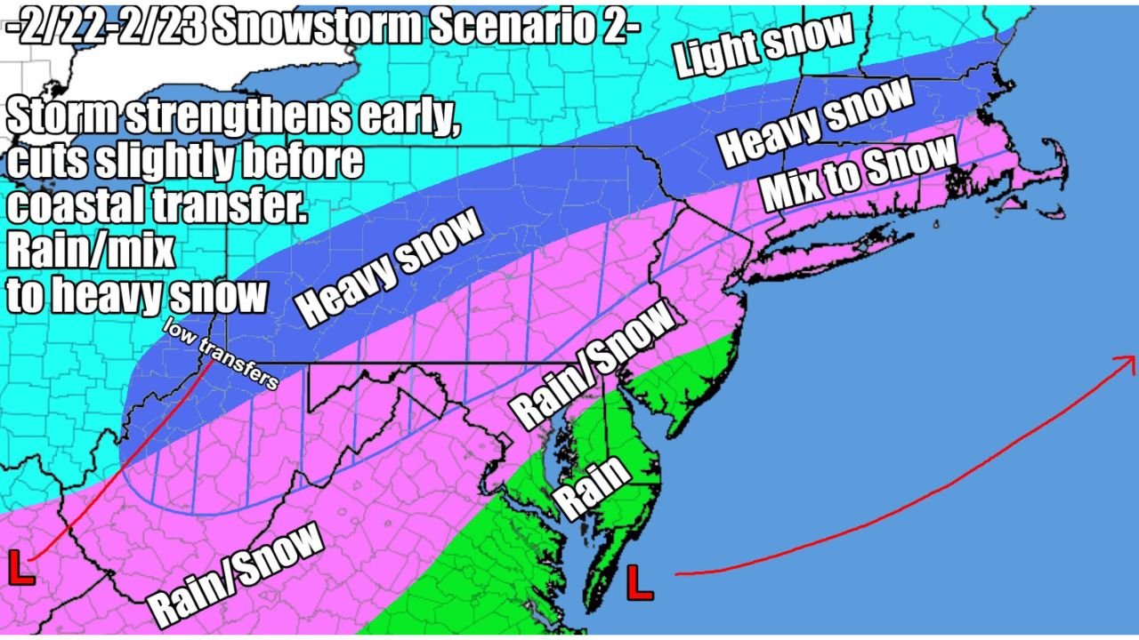
Scenario 2: Storm Strengthens Early and Tracks Near the Coast
The second scenario presents a more impactful outcome. In this case, the storm intensifies earlier and cuts slightly closer to the coastline before transferring energy offshore.
That evolution could bring heavy snow to interior Pennsylvania, northern New Jersey, and southern New York, with a broad swath of rain/snow mix transitioning to heavy snow in parts of the Mid-Atlantic.
Under this setup, areas north and west of the I-95 corridor would have the highest risk of significant accumulation. Coastal sections of New Jersey and Delaware could begin as rain before switching to snow as colder air filters in.
This scenario represents a more organized and stronger system capable of widespread impacts.
Scenario 3: Inland Low Weakens Quickly, Clean Transfer Boosts Snow
The third scenario is considered a “thread-the-needle” solution. Here, the inland low weakens quickly, allowing for a clean transfer of energy to a developing coastal low.
This clean transfer could result in a more favorable snow setup for much of Pennsylvania, New Jersey, New York, and southern New England.
Heavy snow would be more widespread in this case, particularly across interior sections and possibly extending toward the coast if cold air remains entrenched.
This scenario hinges on precise timing between the weakening inland low and strengthening coastal storm. Small shifts could greatly change outcomes.
Scenario 4: Cold Air Overpowers System, Storm Misses South
The fourth and least impactful scenario involves strong cold air suppressing the storm too far south. In this case, the system would struggle to intensify and track well offshore.
That would leave much of Maryland, Pennsylvania, and New Jersey with little more than light snow or flurries, primarily affecting southern coastal zones.
While colder air would be in place, precipitation would be limited due to the storm’s suppressed track.
Why Confidence Remains Low
At this range, model guidance often shifts significantly from run to run. Some solutions favor stronger coastal development, while others weaken the system or push it south.
Forecasters stress that snowfall maps shown at this distance are simply illustrations of potential outcomes, not final predictions.
Key variables include:
- Timing of inland-to-coastal transfer
- Strength of upper-level energy
- Position of cold air mass
- Exact low-pressure track
Even a minor shift of 50–100 miles could alter snowfall totals dramatically from Baltimore to New York City.
What Residents Should Watch
Communities across Maryland, Pennsylvania, New Jersey, and New York should monitor forecast updates through the week. As the system moves within three days of impact, model agreement should improve and confidence will increase.
For now, this remains a high-uncertainty winter weather setup with multiple plausible outcomes.
ChicagoMusicGuide.com will continue tracking developments and refining the forecast as new data becomes available. For ongoing coverage of winter storms across the Mid-Atlantic and Northeast, visit ChicagoMusicGuide.com.