
Massachusetts, Connecticut, and Rhode Island Dig Out After Widespread 10–20 Inch Snowfall From January 25–26 Winter Storm
UNITED STATES — A powerful late-January winter storm delivered widespread heavy snowfall across southern New England, burying large portions of Massachusetts, Connecticut, and Rhode Island under double-digit accumulations between January 25 and January 26.
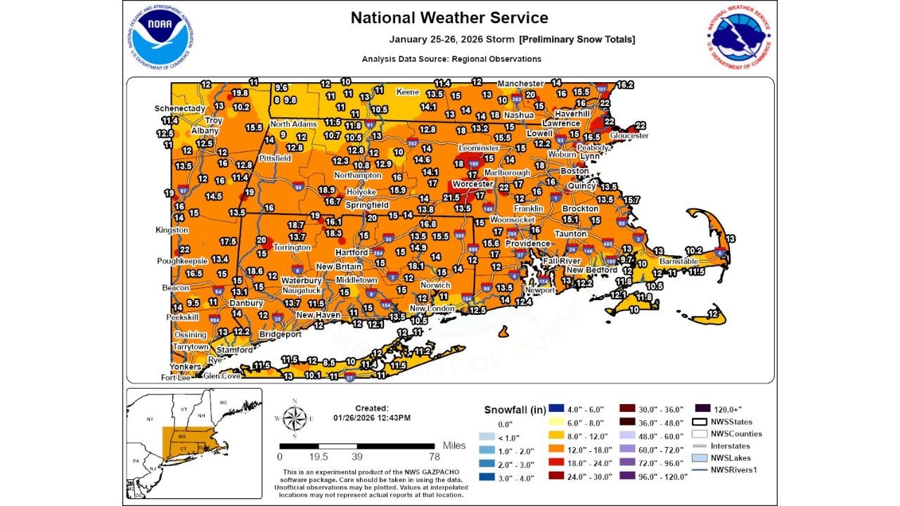
Preliminary snowfall analysis from the National Weather Service shows a broad and consistent snow footprint across the region, with few areas escaping warning-level totals. While some light snow showers lingered after the main system exited, the bulk of accumulation occurred during the core phase of the storm.
Massachusetts Records Widespread 12–20 Inch Snow Totals
Across Massachusetts, snowfall totals were impressive and highly uniform. Interior and northeastern sections of the state saw some of the highest accumulations of the event.
Cities including Worcester, Marlborough, Leominster, Lowell, Lawrence, and Gloucester reported totals generally ranging from 15 to over 20 inches. Portions of central Massachusetts approached the upper end of that range, while eastern coastal communities still measured 10–14 inches despite some early storm mixing concerns.
Connecticut Sees Consistent Double-Digit Accumulation Statewide
In Connecticut, the storm produced a remarkably even snowfall distribution, particularly across central and northern counties.
Communities such as Hartford, Torrington, Waterbury, Middletown, and Norwich reported 14–18 inches, with isolated higher totals nearing 20 inches in elevated terrain. Snowfall tapered closer to 10–13 inches near the southern shoreline, but remained impactful across the entire state.
Rhode Island Impacted Despite Coastal Location
Despite its coastal exposure, Rhode Island experienced a significant winter storm with few misses.
Snowfall totals across much of the state ranged from 12 to 17 inches, including the Providence metro area. Locations near Narragansett Bay and the immediate south coast reported slightly lower totals, but still well within warning criteria.
Why This Storm Produced Such High Snow Totals
Several atmospheric factors aligned to create an efficient and high-impact snowfall event:
- Strong cold air firmly established ahead of the storm
- Favorable offshore coastal low track
- Minimal dry-slot intrusion
- Periods of snowfall rates near or above 1 inch per hour
These ingredients allowed snow to accumulate rapidly and consistently across all three states.
Cleanup Continues as Snow Lingers
While snowfall has largely ended, cold temperatures will prevent rapid melting. Snowbanks and residual impacts are expected to persist through the week as cleanup operations continue across Massachusetts, Connecticut, and Rhode Island.
No significant additional snowfall is expected from this system.
What This Means Going Forward
This January 25–26 storm stands out as one of the most widespread snow events of the 2025–2026 winter season in southern New England, delivering heavy totals across three states with very few localized misses.
Did this storm live up to expectations where you live? Share your snowfall totals and stay with ChicagoMusicGuide.com for continued winter weather coverage and analysis.