
Mid-February Pattern Mirrors Historic Feb 1978 Setup as Midwest, Plains, and East Coast Watch Potential Snow Signal
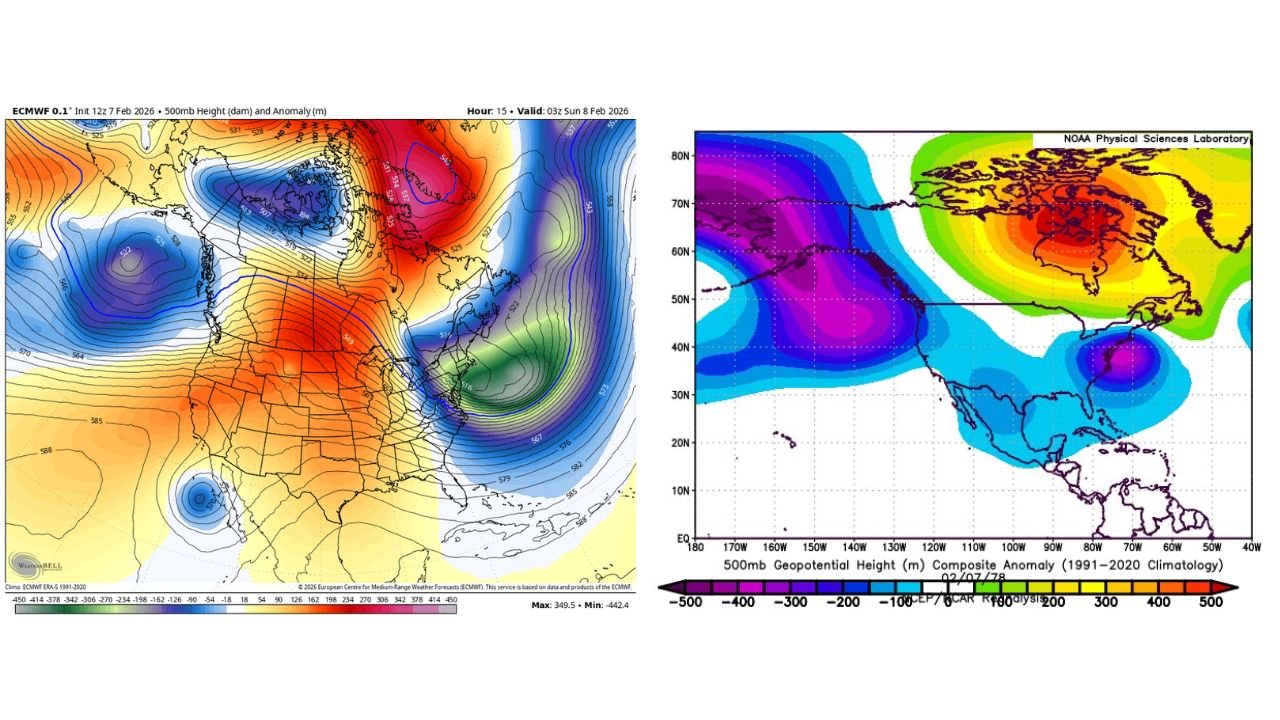
UNITED STATES — Large-Scale Pattern Shows Familiar February Blocking Look Across the central and eastern United States, mid-February 2026 is shaping up with a large-scale atmospheric pattern that closely resembles historic winter setups, including the well-known February 7, 1978 negative dive pattern.
While this current configuration is shifted slightly farther east, the overall genre of the pattern remains similar, which explains why it is drawing attention despite uncertainty.
Upper-air analysis at 500mb heights shows a pronounced ridge over central North America with troughing displaced into the eastern U.S., a classic winter configuration capable of producing focused snow events rather than widespread storms.
How This Pattern Compares to the February 7, 1978 Event
The 1978 event featured a deeper and farther-west trough, allowing cold air and storm energy to impact a broader portion of the country.
In the current setup, the trough axis is shifted eastward, which limits the storm’s footprint and keeps impacts more localized.
Key differences include:
- The 1978 system was better forecasted and more widespread
- The current setup appears narrower in scope
- Snowfall impacts, if they occur, would affect millions, but far fewer than in 1978
Despite this, the similarity in upper-level structure explains why the signal is being discussed heavily online.
Central U.S. Temperature Outlook Remains Above Average
Model consensus through Weeks 1 and 2 shows most of the Central U.S. running above average, including:
- Great Plains
- Midwest
- Lower Mississippi Valley
This warmth is reinforced by a persistent ridge, preventing sustained Arctic air from fully pressing southward during the early portion of the period.
West Coast Trends Toward Below-Average Temperatures
By Week 3, the negative Pacific-North American pattern (-PNA) remains in place, keeping troughing locked over the western U.S.
As a result:
- California
- Oregon
- Washington
- Intermountain West
are favored to see below-average temperatures, with colder air repeatedly cycling into the region.
East Coast Cooling Depends on AO and NAO Behavior
The Eastern U.S. outcome hinges on whether troughing returns, supported by a negative Arctic Oscillation (-AO) and negative North Atlantic Oscillation (-NAO).
If this occurs:
- Mid-Atlantic
- Northeast
- Parts of the Ohio Valley
could see below-average temperatures return, increasing the potential for snow events, though timing and placement remain uncertain.
Lake-Effect Snow Signal: Low Confidence but Notable
One model scenario briefly shows a band of lake-effect snow extending unusually far south, potentially reaching:
- Ohio
- Kentucky
- Southwest Virginia
- Tri-Cities region
However, confidence is extremely low.
Model solutions vary wildly, and the band could:
- Stay far north
- Shift east or west
- Miss entirely
If it materializes, localized accumulations of 0.5 to 1 inch would be possible, but this remains speculative.
Why AI Model Storm Hype Is Being Dismissed
There has been significant online discussion regarding AI-driven model solutions suggesting a major Feb 14–15 East Coast winter storm.
Based on hemispheric analysis, this concern is not supported.
Key reasons include:
- AI models remain single deterministic solutions
- No ensemble support
- Poor alignment with the hemispheric pattern
- A strong MJO signal moving into Phase 3, historically unfavorable for East Coast snowstorms
Simply put, faster model output does not equal higher reliability.
Bottom Line: A Talked-About Snow Event, Not a Historic One
This mid-February setup may produce a snowstorm that millions notice, particularly because of its surprising placement, but it does not appear capable of reaching the scale or impact of February 1978.
The pattern supports:
- Localized snow potential
- Sharper regional contrasts
- High uncertainty on exact placement
It does not support a widespread, high-impact East Coast storm.
Have you noticed unusual temperature swings or early signs of winter weather where you live?
We want to hear from readers across Illinois, the Midwest, and the East Coast. Share what you’re seeing on the ground, how this pattern is affecting your area, and whether you think this mid-February setup delivers snow or fizzles out. Join the conversation and stay updated with ongoing weather coverage on ChicagoMusicGuide.com.