
Midwest Tornado Threat Builds Thursday as Illinois and Indiana Face Isolated but Dangerous Setup
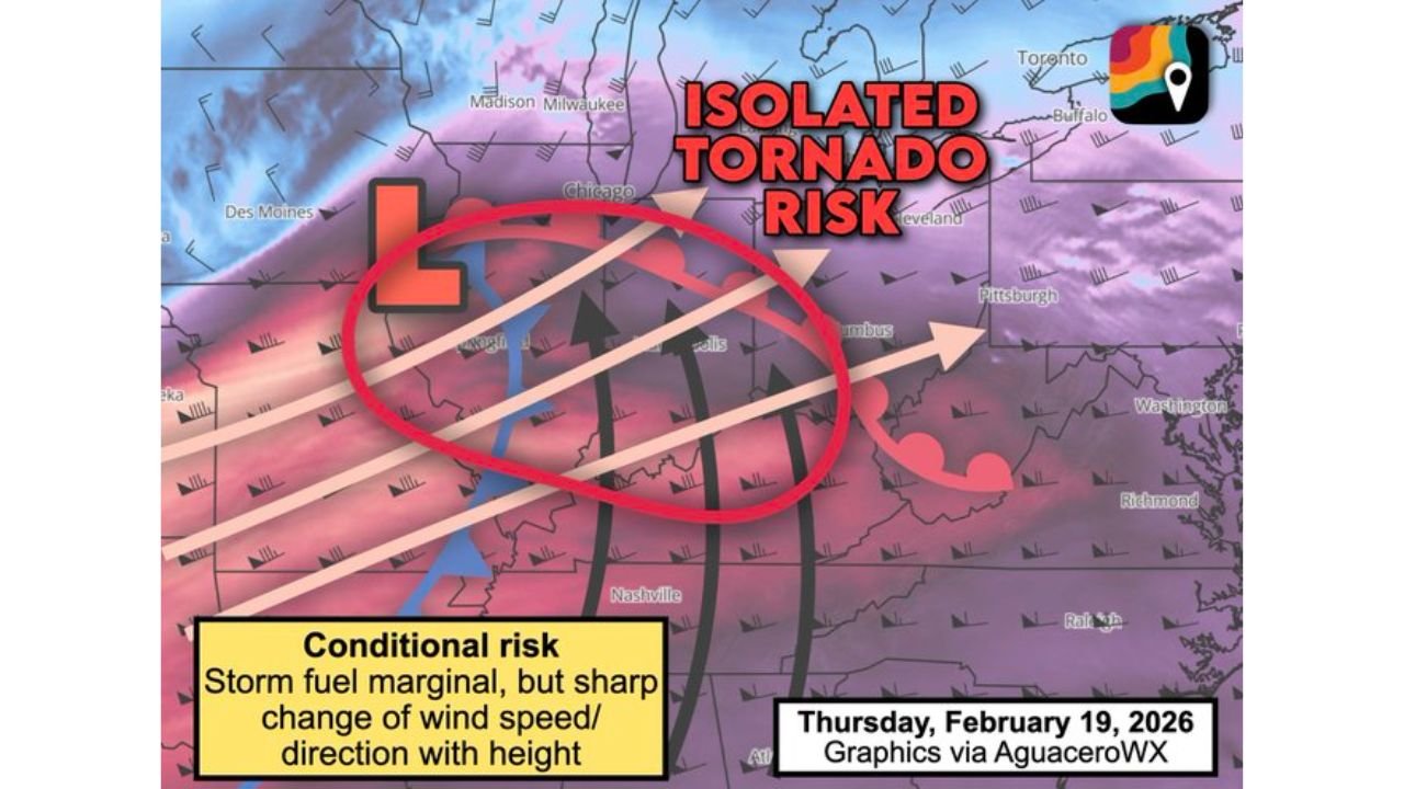
ST. LOUIS, MISSOURI — An emerging storm system is setting up an isolated tornado risk Thursday, February 19, stretching from St. Louis and Carbondale northeast into central Illinois, Indiana, and northern Kentucky. Forecasters have placed the region under a Level 2 out of 5 “Slight Risk,” signaling the potential for a few rotating storms if atmospheric conditions align.
The threat is described as conditional, meaning tornado development will depend heavily on how much instability builds ahead of an approaching cold front.
Surface Low Pulling in Warm, Humid Air
A developing surface low pressure system positioned near southeast Iowa or western Illinois will draw warmer, more humid air northward into parts of the Midwest. This surge of moisture is a necessary ingredient for thunderstorm formation.
However, forecasters caution that it remains unclear how much instability — or storm fuel — will actually be available. If instability remains limited, storm coverage may be sparse. If enough instability develops, thunderstorms could intensify quickly along the advancing cold front.
This uncertainty is why meteorologists are labeling the risk as “conditional.” The environment may be capable of supporting severe storms, but storm formation itself is not guaranteed to be widespread.
Wind Shear Environment Favors Rotation
While instability remains questionable, the wind profile in the atmosphere is notably strong. Surface winds are expected to blow from the south, while stronger mid-level jet stream winds race overhead from the west-southwest.
This change in wind speed and direction with height — known as wind shear — is a key factor in tornado formation. Any thunderstorm that grows tall enough to tap into these stronger winds could begin rotating.
Meteorologists note that storms capable of reaching higher altitudes may rotate “perhaps profusely,” given the sharp change in wind direction and speed with height. The real question remains whether enough storms will develop and intensify within this environment.
Areas from Springfield, Illinois, through Indianapolis, Indiana, and into northern Kentucky sit within the highlighted corridor of concern.
Storm Development Hinges on Cold Front Timing
The advancing cold front will act as the primary trigger for thunderstorm development. If storms form early and have access to the warm, humid air mass ahead of the front, the tornado risk could increase.
On the other hand, if the cold front moves through quickly or instability remains weak, storms may struggle to organize into severe cells.
This setup places parts of central Illinois, Indiana, and northern Kentucky in a delicate balance between strong wind shear and uncertain storm fuel. Even isolated storms could pose a risk if they become organized.
Level 2 “Slight Risk” Signals Isolated but Serious Threat
The current designation of Level 2 out of 5 means scattered severe storms are possible, though widespread severe weather is not expected. The primary concern remains isolated tornadoes, along with potential damaging wind gusts.
Communities across St. Louis, Carbondale, Springfield, Indianapolis, and Louisville should stay weather-aware Thursday. Even isolated tornadoes can cause significant localized damage.
Forecasters will continue monitoring:
- How much moisture and instability develop
- The exact track of the surface low
- Cold front timing
- Storm coverage and intensity
Confidence in widespread severe weather remains low at this time, but the atmospheric ingredients for rotating storms are clearly present.
As Thursday approaches, updates may refine the tornado corridor or adjust risk levels. Residents across Illinois, Indiana, and northern Kentucky are encouraged to review severe weather safety plans and stay informed.
For continuing updates on Midwest severe weather patterns, storm risks, and forecast analysis, visit ChicagoMusicGuide.com.