
Minnesota, Wisconsin, Michigan Brace for 6–12+ Inches — Some Areas 12–24 Inches — as Powerful Sunday Winter Storm Targets Midwest While Severe Threat Builds from Texas to the Ohio Valley
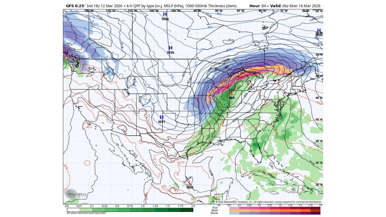
MINNEAPOLIS, MINNESOTA — Another powerful winter storm is poised to sweep across the Midwest beginning Sunday and continuing into early Monday, bringing widespread 6–12 inches of snow, with localized totals potentially reaching 12–24 inches in parts of Minnesota, Wisconsin, and Michigan.
At the same time, the southern flank of this dynamic system may trigger severe thunderstorms from Texas into the Ohio Valley, creating a sharp divide between heavy snow to the north and damaging storms to the south.
Heavy Snow Focused on Minnesota, Wisconsin, and Michigan
Forecast guidance shows a rapidly deepening low-pressure system lifting northeast toward the Great Lakes late Sunday. A broad deformation band on the northwest side of the storm is projected to stretch from:
- Central and northern Minnesota
- Across much of Wisconsin
- Into Michigan’s Upper Peninsula and northern Lower Michigan
The most intense snowfall rates are expected near and north of the low track, where strong lift and cold air overlap. Cities that could see significant accumulation include:
- Minneapolis–St. Paul
- Duluth
- St. Cloud
- Green Bay
- Wausau
- Marquette
Snow totals in this corridor may exceed a foot in localized areas, with isolated pockets potentially pushing toward two feet if banding persists.
Moderate Snow Extending Southward
South of the heaviest band, accumulating snow remains likely across portions of:
- Northern Iowa
- Southern Wisconsin
- Northern Illinois
- Parts of Lower Michigan
Several inches of snow could fall in these regions, enough to create hazardous travel conditions Sunday into early Monday.
Meanwhile, lighter snow or flurries could extend as far south as Arkansas and Tennessee by early Monday morning as colder air wraps into the backside of the storm.
Severe Weather Risk from Texas to the Ohio Valley
While heavy snow dominates the north side of the system, the southern sector tells a different story.
A strong corridor of moisture and instability ahead of the cold front may support severe thunderstorms from eastern Texas through Louisiana, Mississippi, Alabama, Tennessee, and into Kentucky and the Ohio Valley.
Primary threats include:
- Damaging wind gusts
- Isolated tornadoes
- Heavy rainfall
Major cities that may need to monitor severe weather potential include:
- Dallas
- Shreveport
- Memphis
- Nashville
- Louisville
The sharp contrast between blizzard-like conditions in the Upper Midwest and severe thunderstorms in the South underscores the strength of this developing system.
Timing and Travel Concerns
Snow is expected to intensify Sunday across the Upper Midwest, with peak impacts Sunday night into early Monday. Travel disruptions are likely along major corridors including:
- Interstate 94 in Minnesota and Wisconsin
- Interstate 35
- Highways surrounding Lake Superior and Lake Michigan
Air travel hubs such as Minneapolis–St. Paul and potentially Chicago could experience delays depending on the storm track.
A High-Impact Start to the Week
This storm represents one more significant winter punch before spring fully takes hold across the Midwest. With the potential for double-digit snowfall totals in Minnesota, Wisconsin, and Michigan — alongside severe weather in the South — residents across multiple regions should prepare for impactful conditions.
Stay alert for updated forecasts and advisories as the system strengthens.
For continuing updates on major storms affecting the United States, visit ChicagoMusicGuide.com.