
New England and the Northeast Corridor Face Explosive Snowfall Rates as RRFS Model Shows 3–5 Inches Per Hour Potential
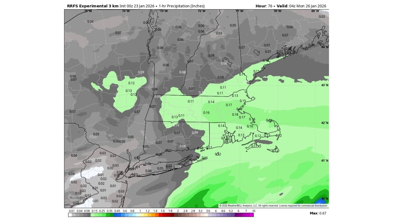
UNITED STATES — A rapidly intensifying winter storm is drawing heightened concern across New England and parts of the Northeast Corridor, as new high-resolution RRFS (Rapid Refresh Forecast System) model guidance indicates exceptionally intense precipitation rates late Sunday night into early Monday. The latest data shows up to 0.20 inches of liquid-equivalent precipitation in just one hour, a signal that could translate into 3 to 5 inches of snow per hour in the coldest parts of the storm.
RRFS Model Signals Extreme Short-Duration Snowfall
The experimental RRFS, widely viewed as the long-term replacement for the NAM, is showing eye-catching hourly precipitation output across portions of the Northeast, particularly from southern New England into eastern New York and northern New Jersey. Hourly precipitation values approaching 0.15 to 0.20 inches appear within a tightly focused deformation band late Sunday night.
In cold-air-dominated setups, this magnitude of hourly QPF often correlates to explosive snowfall rates, especially when strong lift and deep saturation align within the dendritic growth zone.
Where the Most Intense Snow Bands May Set Up
Based on the current placement of the heaviest modeled precipitation, the greatest risk for extreme snowfall rates includes:
- Eastern and central Massachusetts
- Rhode Island
- Southern New Hampshire
- Coastal and interior Maine
- Eastern New York into northern New Jersey
Within this corridor, snowfall could transition from moderate to whiteout conditions in a matter of minutes if banding becomes established.
Why Snowfall Rates Could Reach 3–5 Inches Per Hour
Several atmospheric factors are coming together to support the potential for very high snowfall rates:
- Strong mid-level frontogenesis, focusing lift into narrow zones
- Deep moisture transport off the Atlantic, feeding the storm continuously
- Cold surface and column temperatures, maximizing snow-to-liquid ratios
- Slow-moving or pivoting snow bands, increasing accumulation in short timeframes
When these ingredients overlap, snowfall rates exceeding 3 inches per hour become not only possible, but plausible for short bursts.
Travel and Infrastructure Impacts Could Escalate Rapidly
Snowfall rates of this intensity are capable of overwhelming plow operations, even on major interstates. Roads can become snow-covered within minutes, significantly reducing visibility and traction. Airports across Boston, Providence, and the New York City metro periphery may experience rapid ground stoppages if intense bands move overhead.
In addition, such high rates often coincide with strong winds, compounding the risk of drifting snow and near-zero visibility.
Why This Forecast Demands Close Monitoring
It is important to note that the RRFS is an experimental, high-resolution model, and exact band placement remains uncertain. However, the consistency of extreme hourly precipitation signals is enough to raise confidence that at least part of New England and the Northeast will see a period of intense snowfall.
Even a brief 1–2 hour window of 3–5 inch-per-hour snow could drastically alter storm totals and impact outcomes.
As the storm approaches, forecasters will be watching for trends that confirm whether these extreme snowfall rates materialize. For continued updates, winter storm analysis, and regional impact coverage across the United States, visit ChicagoMusicGuide.com.