
New York, Michigan, Illinois, Wisconsin, Kentucky, Tennessee, Mississippi, and Louisiana Face Multi-Hazard January Pattern as Lake-Effect Snow, Midwest Winter Storm, and Southern Severe Weather Signals Emerge
UNITED STATES — A volatile and highly active January weather pattern is taking shape across multiple regions of the country, with very different hazards unfolding at the same time depending on location. Based strictly on the latest model data, ensemble guidance, and official outlooks, the situation points to historic lake-effect snow in parts of New York, increasing winter storm potential across the Midwest, and a growing severe weather threat across the Mid-South and Lower Mississippi Valley, while long-range models hint at another possible winter setup later in January.
This is not a single-city or single-state event. The data clearly supports a multi-state, multi-hazard pattern driven by an energetic jet stream, sharp temperature gradients, and deepening surface systems.
Lake-Effect Snow Continues to Hammer Parts of New York
Observed snowfall data confirms extreme lake-effect snow totals across western and northern New York, particularly downwind of Lake Erie and Lake Ontario.
- Communities southeast of Buffalo have reported multiple feet of snow
- Areas east of Lake Ontario, including the Tug Hill Plateau, have seen snow totals exceeding four to five feet
- Persistent snow bands have remained locked in place due to steady cold air flow across relatively warm lake waters
This type of setup favors localized but historic snowfall, producing dangerous travel conditions, road closures, and prolonged cleanup operations in the hardest-hit zones.
Midwest Winter Storm Signals Increase for Michigan, Illinois, Indiana, and Ohio
Attention then shifts west and south into the Midwest, where both GFS and ECMWF guidance suggest a potentially intense winter storm developing late Friday into Saturday.
Key signals in the data include:
- A deepening surface low pressure system
- A broad swath of snow on the cold side of the storm
- Tight pressure gradients capable of strong winds and blowing snow
At this range, model disagreement remains high, particularly regarding storm track and temperature profiles. Small shifts north or south could mean:
- Heavier snow for Michigan, northern Illinois, and Wisconsin
- Mixed precipitation or rain farther south into Indiana and Ohio
While confidence is still developing, the impact potential is clearly elevated based on current guidance.
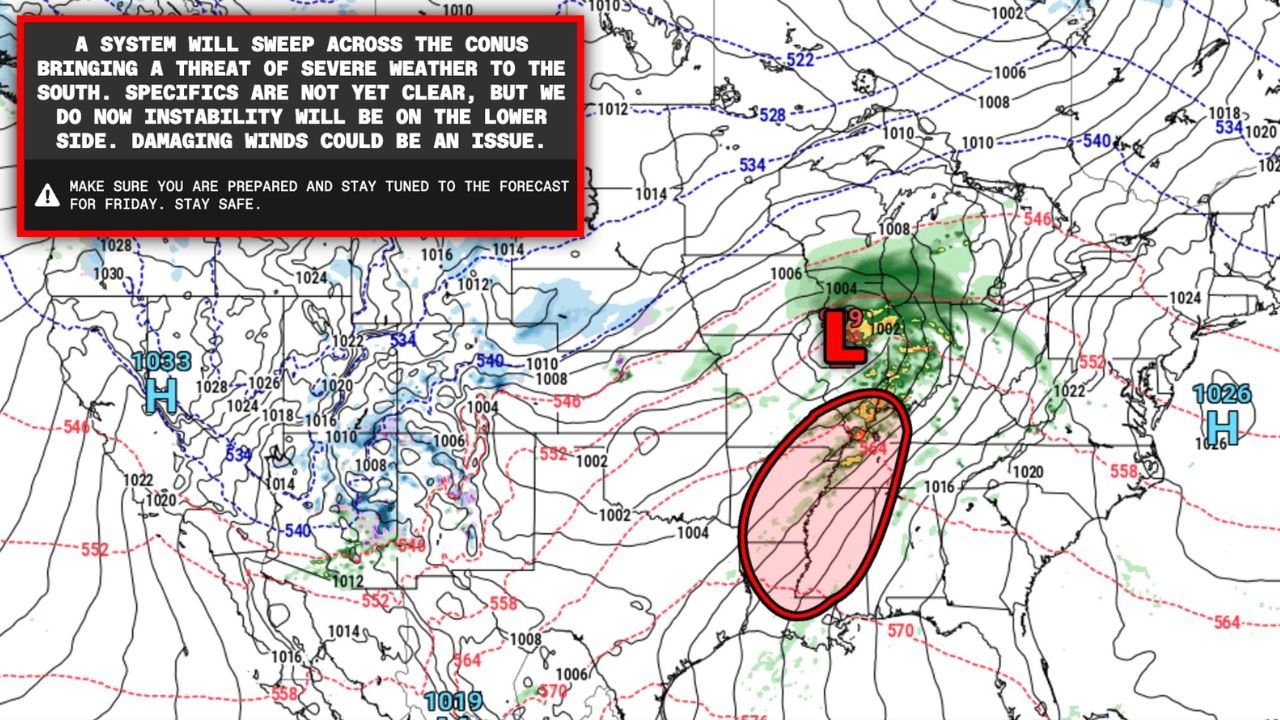
Severe Weather Risk Expands Across Kentucky, Tennessee, Mississippi, and Louisiana
On the southern side of the same system, a very different hazard emerges.
The Storm Prediction Center (SPC) has introduced a severe weather risk area for Friday, January 9, stretching from western Kentucky through Tennessee and Mississippi and into Louisiana.
Model trends show:
- Improving moisture return from the Gulf of Mexico
- Strong wind fields supportive of organized storms
- The possibility of damaging straight-line winds and isolated tornadoes
Because this is a wintertime severe weather setup, instability remains marginal, keeping confidence below average. However, the increasing consistency across ensemble guidance suggests the threat is becoming more credible and cannot be ignored.
Mid- to Late-January Winter Signals Appear in Long-Range Models
Beyond the immediate storm threats, both long-range GFS and ECMWF runs are beginning to hint at another potential winter system affecting parts of the Midwest and Great Lakes later in January.
These scenarios remain low-confidence and highly volatile, meaning:
- They could disappear in future runs
- Timing and placement are uncertain
- Stronger solutions often appear farther out in model cycles
Still, forecasters note that this pattern is more favorable than recent weeks, making it something to monitor closely rather than dismiss outright.
A Highly Volatile, Multi-State January Pattern
The data supports a split and complex national pattern, with:
- Extreme lake-effect snow in New York
- Possible winter storm impacts across the Midwest
- An expanding severe weather risk across the Mid-South and Lower Mississippi Valley
- Additional winter potential later in January
With sharp contrasts in air masses and an active jet stream, forecast changes are likely, and impacts will vary dramatically by state and region.
Stay connected with ChicagoMusicGuide.com for continued data-driven weather updates, impact breakdowns, and evolving forecasts as this dynamic January pattern unfolds.