
Norlun Trough and Ocean-Effect Bands Could Push Snow Totals Higher Across Massachusetts, Rhode Island, and Southern New Hampshire
NEW HAMPSHIRE — A late-night into tomorrow winter weather setup is drawing close attention across southern New England as a Norlun trough interacts with ocean-effect and coastal enhancement, creating a scenario where snowfall totals may vary sharply over short distances. While average accumulations remain modest, guidance shows a higher ceiling where narrow bands lock in place.
The system favors a play-by-play evolution rather than a uniform snowfall, increasing the risk of localized surprises.
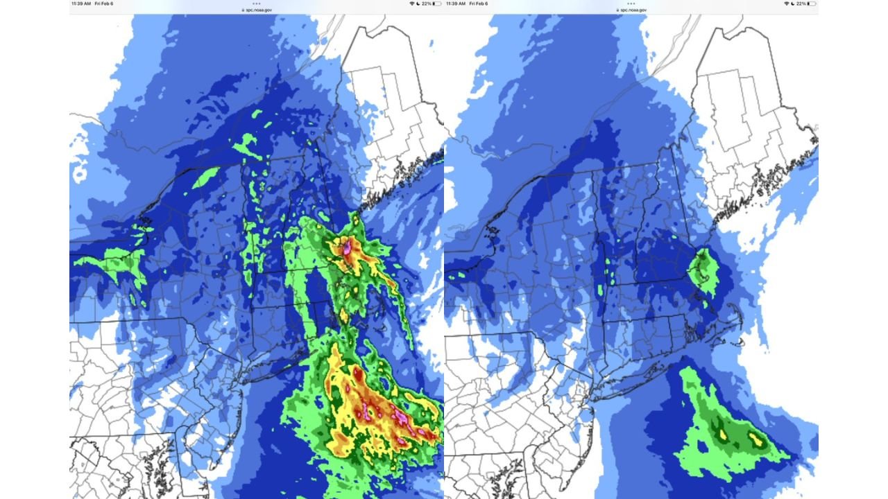
Mean Snowfall Scenario Favors Widespread Light to Moderate Accumulations
The most likely snowfall outcome across central and eastern Massachusetts, Rhode Island, and southern New Hampshire supports a general range of 1 to 4 inches for many communities.
In this scenario:
- Light blue shading represents 1–2 inches
- Medium blue indicates 2–4 inches
- Darker blue pockets suggest 4–6 inches where banding persists
This mean outcome reflects the most probable placement of the Norlun trough and associated moisture.
Norlun Trough Sets Up Inland Snow Axis
The Norlun trough itself is expected to track across central Massachusetts into portions of Rhode Island, providing focused lift and steady snowfall inland.
Communities under this axis may see 3 to 5 inches, with locally higher amounts approaching 6 inches where mesoscale banding develops. Snowfall here should be steadier and longer-lasting compared to coastal zones, though still sensitive to subtle shifts.
Ocean-Effect Enhancement Raises Ceiling Along the Massachusetts Coast
Along the Massachusetts coastline, particularly near the North Shore, ocean-effect enhancement becomes a key wildcard.
Cold air flowing over relatively warmer Atlantic waters allows narrow but intense snow bands to form. In less likely but still plausible scenarios, these bands could push snowfall totals toward 6 to 8 inches, especially where coastal enhancement aligns with the Norlun trough.
These higher totals are not expected everywhere, but the potential exists where bands persist longest.
Higher-End Outcomes Remain Uncertain but Possible
The maximum snowfall depiction shows a higher-end scenario where isolated locations “cash in” if both the Norlun trough and ocean-effect bands overlap efficiently.
While 12-inch-plus totals remain a low-probability outcome, the presence of green and warmer color shading offshore highlights how quickly snowfall rates could escalate if conditions align. This underscores the high bust potential associated with the event.
What This Means for Travel, Shows, and Evening Plans
For residents, venue operators, and concert-goers across Boston, Providence, and surrounding communities, impacts may hinge more on timing and intensity than raw totals.
Brief periods of heavier snow could coincide with overnight or morning travel, leading to sudden visibility reductions and slick roads even where storm totals remain moderate. Coastal and near-coastal areas should be especially alert for rapidly changing conditions.
ChicagoMusicGuide.com will continue tracking evolving winter patterns and their potential effects on travel, events, and weekend plans across the region.