
North Carolina Snow Watch: 30–40% Chance of Measurable Snow Near Raleigh and East of the Triad Sunday (Jan. 18)
NORTH CAROLINA — Forecasters are closely monitoring the potential for light snow in central North Carolina late Saturday night into Sunday, Jan. 18, as guidance remains split: some model solutions produce measurable snowfall while others keep the region mostly dry. A probability outlook indicates a 30–40% chance of at least a half inch of snow, focused mainly east of the Triad.
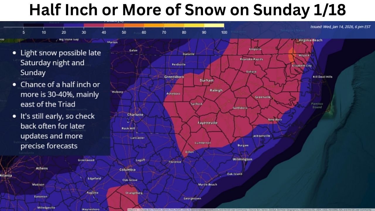
What the latest outlook is showing for Sunday (Jan. 18)
The map shared in the briefing highlights the probability of 0.5″ (half an inch) or more of snow on Sunday. The best odds are centered across central-to-eastern North Carolina, including the general corridor from the Triangle toward communities farther east.
Key takeaways from the graphic:
- Light snow is possible late Saturday night and Sunday.
- The 30–40% zone is mainly east of the Triad, meaning areas east of Greensboro/High Point/Winston-Salem have the better chance to see measurable accumulation.
- Confidence is not locked in yet, and updates are expected as guidance narrows timing and track.
Where the measurable-snow signal is strongest
Based on the shaded probability area, the most consistent “watch zone” runs through a broad part of central and eastern North Carolina, including:
- The Triangle region (Raleigh/Durham area) and nearby communities
- A wider stretch toward eastern NC, where the probability shading remains more pronounced than it is farther west
Meanwhile, locations farther west—closer to and west of the Triad—appear to sit in a lower-probability zone in this particular snapshot, which matches the note that the better odds are east of the Triad.
Timing: why late Saturday night into Sunday matters
The outlook specifically flags a window of concern late Saturday night through Sunday, which is important because even a “light snow” scenario can cause outsized problems if it overlaps with:
- Overnight temperatures near or below freezing
- Early-morning travel
- Periods when road crews have less time to pretreat or respond
Even small accumulations can become a bigger issue if temperatures support slick spots on bridges, ramps, and untreated side roads.
Why forecasters are cautious right now
The briefing notes that forecasters reviewed a large spread of model guidance, and the solutions are not aligned yet. That usually means one (or more) of these uncertainties is still in play:
- The storm track (north/south shifts can change rain vs. snow quickly)
- The timing (arriving earlier at night vs. later in the day can change totals)
- The temperature profile near the surface (a small change can flip outcomes)
In plain terms: the potential is real, but it’s still early enough that the final result could range from flurries to a light accumulation, or even a mostly dry outcome in some areas.
What this could mean for travel, plans, and Sunday events
If the measurable-snow scenario verifies in the higher-probability zone:
- Expect slower travel and the risk of patchy slick roads, especially early Sunday
- Allow extra time if you’re driving between cities in central/eastern NC
- Outdoor plans could be impacted by cold, damp conditions, even where totals stay low
For anyone heading to a show, venue, rehearsal, or Sunday night event, the biggest takeaway is simple: watch updates and plan for a slower commute, especially if you’re traveling from west to east across the state.
How to prepare now (without overreacting)
This is the smart middle ground while confidence builds:
- Check forecasts twice daily through the weekend (morning and evening updates)
- Keep your phone charged and enable weather alerts
- If you must drive Sunday, keep extra distance and avoid sudden braking on bridges/overpasses
- Have a backup plan for travel if your route crosses the east-of-Triad higher-probability zone
When the next update should sharpen the forecast
With the window centered on late Saturday night into Sunday, the forecast typically becomes clearer as newer model runs capture the event at shorter range. Expect meaningful refinement on:
- Saturday morning
- Saturday evening
- Early Sunday
That’s when timing and precipitation type usually become much easier to pin down.
If you’re in North Carolina and this weekend forecast affects your plans, what are you seeing where you live—flurries, nothing at all, or a real chance of accumulation? Share what you’re noticing and keep the conversation going at ChicagoMusicGuide.com.