
North Dakota Braces for Freezing Rain and Ice Glaze as Slippery Travel Threatens Saturday Morning
NORTH DAKOTA — Increasing confidence is growing for freezing rain across western and parts of central North Dakota early Saturday, with medium probabilities for a glaze of ice that could create dangerous travel conditions, according to the latest forecast data from the National Weather Service in Bismarck.
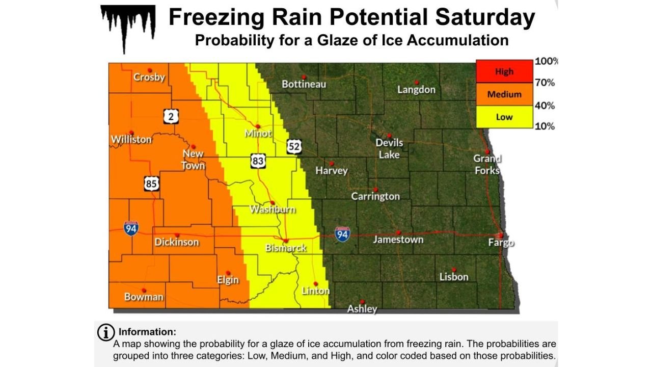
Forecast guidance shows precipitation arriving very early Saturday morning, initially as light snow, before transitioning to freezing rain across much of western North Dakota. The most concerning impacts are expected from Williston and Crosby south through Dickinson, Bowman, and Elgin, extending east toward Bismarck and Washburn, where ice accumulation could coat untreated roads and bridges.
Timing and evolution of the system
The highest risk window for freezing rain stretches from pre-dawn Saturday through early afternoon. During this time, surface temperatures are expected to remain below freezing while warmer air moves in aloft, creating ideal conditions for freezing rain rather than snow.
As the system progresses, precipitation is forecast to shift eastward across North Dakota Saturday afternoon, with areas east of the Missouri River—including Jamestown and Fargo—seeing mostly snow instead of ice. This transition should help limit icing impacts in eastern portions of the state.
Areas at highest risk
Forecast probability maps highlight a medium chance (40–70%) of at least a glaze of ice across western and parts of central North Dakota. While widespread major ice accumulation is not expected, even a thin glaze can be enough to cause slick roads, reduced braking ability, and hazardous driving conditions, especially during the early morning hours.
Communities along Highway 85, Highway 83, and Interstate 94 west of Bismarck may experience the most noticeable impacts, particularly on elevated roadways, overpasses, and untreated secondary roads.
Travel impacts and safety concerns
The National Weather Service warns that very slippery surfaces are likely, with the greatest danger occurring when freezing rain is actively falling. Drivers are urged to allow extra stopping distance, avoid sudden braking, and not use cruise control during icy conditions.
Even where snowfall is light, freezing rain can create rapidly deteriorating road conditions, making travel treacherous in a short period of time.
What happens next
Colder air moving in behind the system is expected to end freezing rain concerns later Saturday, but lingering slick spots may persist into the evening as temperatures remain below freezing. Any ice that forms early in the day could remain on roads well after precipitation ends.
Residents across North Dakota are encouraged to monitor local forecasts and road condition updates closely, especially if traveling early Saturday.