
Ohio Valley Remains Locked in Below-Normal Cold Next Week Despite Slight Temperature Rebound, NWS Data Shows
OHIO VALLEY — Bitterly cold conditions across the Ohio Valley are expected to ease only slightly heading into next week, according to new data from the National Weather Service, with forecasts showing that many locations may still struggle to reach the freezing mark for several more days. While daytime highs will climb compared to late January extremes, temperatures are projected to remain below seasonal averages throughout the entire week.
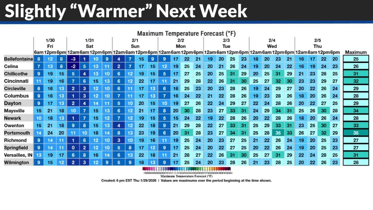
The updated maximum temperature forecast, issued Thursday evening, underscores that the upcoming warmup will be marginal at best, offering limited relief from prolonged cold.
“Warmer” Next Week Still Below Normal Across the Region
The NWS temperature outlook labeled “Slightly ‘Warmer’ Next Week” reflects a relative change rather than a true return to seasonal conditions. Forecast highs across much of Ohio, northern Kentucky, eastern Indiana, and western West Virginia remain largely in the 20s and low 30s through midweek.
Several locations shown in the forecast grid indicate maximum temperatures topping out below freezing, particularly during the early part of the week. Even in areas that briefly rise above 32 degrees, readings remain well below climatological norms for early February.
Cold Air Lingers Despite Gradual Moderation
Although the most extreme Arctic air will retreat, the broader pattern continues to favor persistent cold air dominance across the Ohio Valley. The data shows a slow, uneven moderation rather than a clean transition to milder conditions.
Nighttime temperatures remain especially cold, reinforcing daily freeze–thaw limitations and keeping surfaces cold enough to support lingering ice and snow cover. This sustained cold will limit the impact of any short-lived daytime warming.
Why Some Areas May Not Reach Freezing for Another Week
Forecast guidance highlights that localized cold pockets may remain entrenched due to snowpack, weak solar angle, and limited warm-air advection. In these areas, daily highs may fail to reach 32 degrees for several consecutive days, extending cold-related impacts well into next week.
Meteorologists emphasize that even modest cloud cover or light winds could further suppress daytime warming, especially in valleys and rural locations.
Impacts of Prolonged Below-Normal Temperatures
While the cold is not expected to intensify further, extended below-normal temperatures can still cause disruptions. Potential impacts include:
- Continued icy road conditions, especially overnight and early morning
- Increased heating demand
- Stress on exposed plumbing and infrastructure
- Slower snow and ice melt, prolonging winter hazards
Residents are encouraged to remain cautious during morning travel and continue cold-weather precautions.
What to Watch Going Forward
Forecasters will be monitoring:
- The pace of air mass modification
- Any short-term warm surges that could briefly push temperatures higher
- The influence of cloud cover on daytime highs
While a more substantial warmup is not currently indicated, small shifts in the pattern could still adjust local temperatures by a few degrees.
Despite the promise of slightly higher readings, winter remains firmly in control across the Ohio Valley as February approaches. For continued updates on temperature trends, cold weather outlooks, and regional forecasts, visit ChicagoMusicGuide.com.