
Oklahoma, Arkansas, Missouri, Tennessee, Kentucky, Virginia, North Carolina, and Pennsylvania Face Widespread Snow and Ice Threat as Late-January Winter Storm Gains Momentum
UNITED STATES — Confidence is steadily increasing among long-range and ensemble weather models that a large, high-impact winter storm will slide across a broad section of the country late this week into the weekend, potentially affecting areas from the Southern Plains through the Mid-South, Appalachians, and into the Mid-Atlantic and Northeast. While exact placement and totals remain uncertain, the overall pattern strongly supports a widespread winter weather event with accumulating snow north of the storm track and significant ice risks to the south.
Why This Late-January Pattern Is Raising Red Flags
Recent ensemble guidance, including ECMWF and EPS runs, continues to signal a strong Arctic air mass pressing southward while an active storm system ejects out of the western United States. As this cold air locks in, moisture moving in from the southwest is expected to overrun shallow cold air near the surface — a classic setup for snow, sleet, and freezing rain, especially across the South and interior East.
This configuration is particularly concerning because it favors long-duration precipitation, not a quick-hitting system. Even moderate precipitation rates over several hours could translate into meaningful travel impacts, power outages in ice-prone regions, and delays across major transportation corridors.
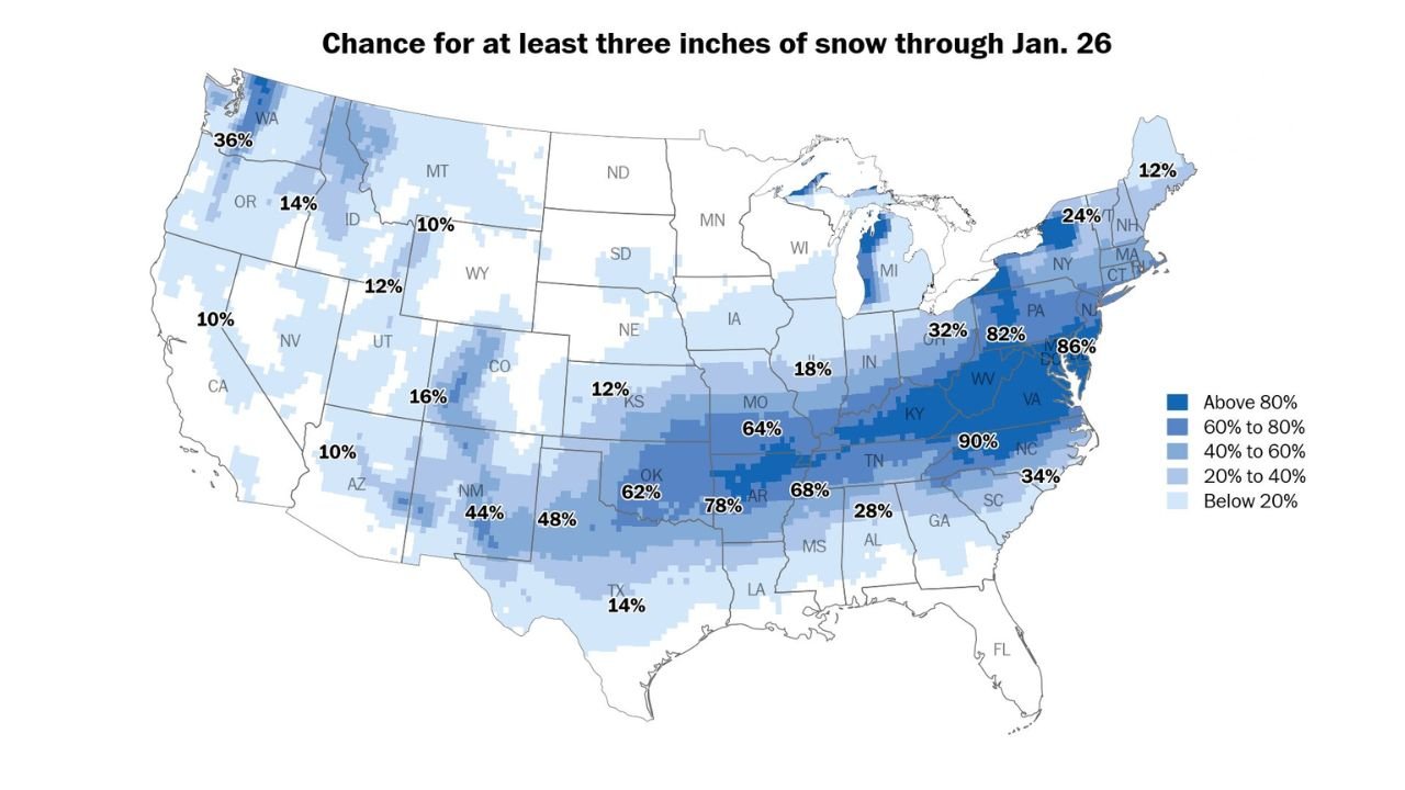
Southern Plains and Mid-South: Snow Chances Rising Sharply
The latest ensemble data shows a notable uptick in snowfall probabilities across Oklahoma and northern Arkansas, with some metro areas now showing near-even odds for at least 4 inches of snow. That represents a significant shift compared to earlier model cycles and highlights how quickly this system is organizing.
Across Missouri, Arkansas, western Tennessee, and northern Mississippi, probabilities for three inches or more of snow are now widespread, suggesting a realistic risk of impactful winter weather even in areas that don’t see heavy snow every winter.
Ice Storm Signal Growing in the Deep South and Carolinas
South of the main snow axis, confidence is building in a dangerous ice setup. Model soundings and freezing-rain probability maps increasingly highlight northern Georgia, South Carolina, and central into eastern North Carolina as areas to watch closely.
Here, warm air aloft combined with surface temperatures at or below freezing could lead to significant ice accretion, which historically causes more damage than snow alone. Even light ice can result in downed trees, power outages, and hazardous road conditions, particularly in regions not equipped for winter weather.
Appalachians and Mid-Atlantic: High Confidence in Accumulating Snow
One of the most consistent signals across guidance is the Appalachians into the Mid-Atlantic, including Kentucky, West Virginia, Virginia, Maryland, and Pennsylvania. Probability maps show 60–90% chances for at least three inches of snow, with some corridors potentially exceeding that threshold if the storm track holds.
Major population centers along the I-81 and I-95 corridors could see disruptive winter travel, depending on timing and precipitation type transitions.
Timing: When Impacts Could Begin
While details are still evolving, the overall timeline suggests:
- Friday: Initial impacts begin in the Southern Plains and lower Mississippi Valley
- Saturday: Storm intensifies and spreads across the Mid-South, Appalachians, and interior East
- Sunday into Monday: Snow and ice shift toward the Mid-Atlantic and Northeast before tapering off
Because this system is not a distant 7–10 day signal, forecast confidence is expected to improve rapidly over the next 48–72 hours.
What Still Needs to Be Resolved
Despite growing confidence in a major event, several key questions remain:
- The exact placement of the heaviest snow band
- How far north warm air aloft intrudes, which could shift snow to ice
- The duration of freezing rain in southern states
Small track changes could dramatically alter impacts for individual cities, underscoring why close monitoring is critical.
What This Means for Readers
This is shaping up to be a high-impact winter storm with national reach, especially for regions that don’t routinely deal with snow and ice. Even modest accumulations could have outsized consequences due to infrastructure sensitivity and timing over a weekend.
Stay Connected
Weather patterns like this evolve quickly. Stay tuned to ChicagoMusicGuide.com for continued updates, refined forecasts, and impact-focused coverage as confidence increases. If this storm affects your area, share what you’re seeing and join the conversation as the situation unfolds.