Oklahoma City Wichita Kansas City And Columbia Face Level 4 Severe Storm Risk Friday With Tornadoes Large Hail And Damaging Winds Expected
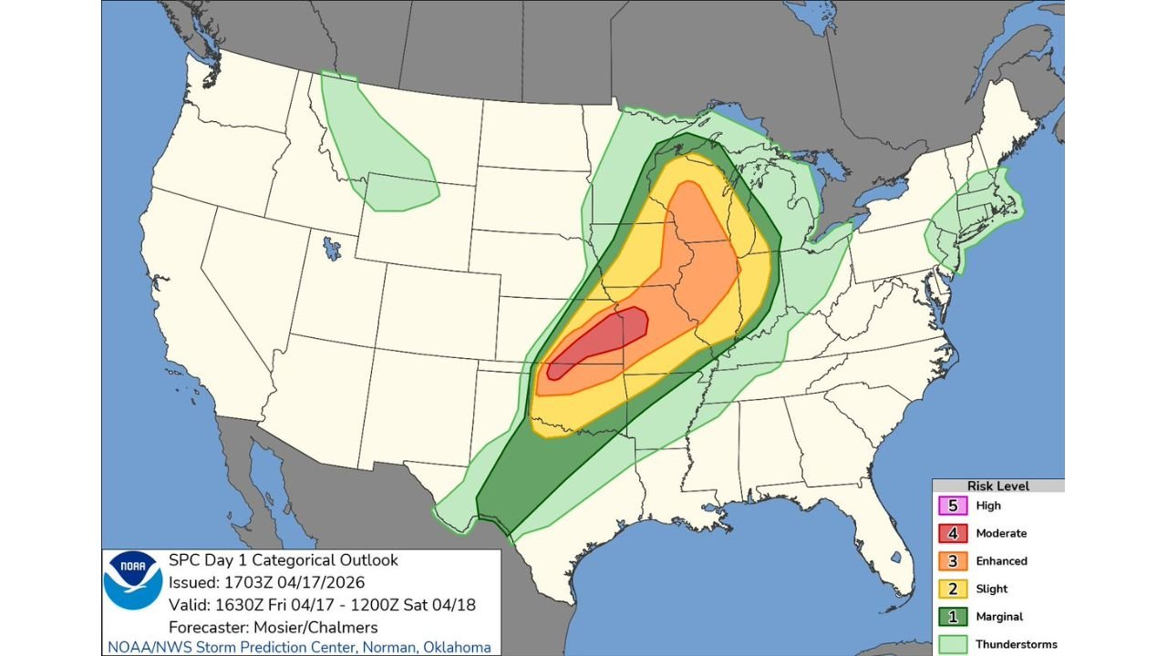
UNITED STATES — A significant Level 4 out of 5 severe weather risk has been issued for Friday, stretching from northwest Oklahoma through central and eastern Kansas into west-central Missouri, placing cities like Oklahoma City, Wichita, Kansas City, and Columbia in the path of potentially dangerous thunderstorms capable of producing tornadoes, large hail, and damaging winds.
Moderate Risk Zone Targets Oklahoma To Missouri Corridor
The highest risk area—classified as a Moderate Risk (Level 4)—covers a corridor from northwest Oklahoma through Kansas and into parts of Missouri, signaling a high likelihood of widespread severe weather.
Cities including Oklahoma City, Enid, Wichita, Topeka, Kansas City, and Columbia fall within or near this elevated risk zone.
Within this region, storms are expected to develop and intensify rapidly, bringing multiple hazards such as:
- Large hail capable of causing significant damage
- Damaging wind gusts potentially exceeding severe thresholds
- A heightened risk of tornado development, including stronger tornadoes in favorable areas
This setup represents one of the more organized and concerning severe weather days, especially given the broad geographic coverage.
Enhanced And Slight Risk Extend Into Midwest And Great Lakes
Beyond the core moderate risk zone, surrounding areas—including parts of Illinois, Iowa, Nebraska, and the Midwest—are under Enhanced (Level 3) and Slight (Level 2) risks.
Cities such as Des Moines, Omaha, Springfield, St. Louis, and even areas closer to Chicago could experience scattered severe storms, although with slightly lower overall intensity compared to the core zone.
In these regions, the primary threats will likely include:
- Strong wind gusts from organized storm lines
- Large hail in stronger cells
- An isolated tornado threat, particularly with any discrete storms
The risk gradually decreases farther from the core, but impacts remain possible across a wide area.
Storm Development Expected To Intensify Through Afternoon And Evening
Storms are expected to initiate during the afternoon hours, particularly across Oklahoma and Kansas, before strengthening and expanding northeast into Missouri by evening.
As storms mature, they may evolve into:
- Discrete supercells early in the event, capable of producing tornadoes and very large hail
- Clusters or lines of storms later, increasing the threat for widespread damaging winds
This evolution increases the complexity of the event, as different hazards dominate at different stages.
Why This Setup Has High Impact Potential
This severe weather event stands out due to the combination of favorable atmospheric ingredients, including:
- Strong instability providing storm energy
- Wind shear supporting storm rotation
- Large-scale forcing helping storms organize over a wide area
Together, these factors create an environment where storms can develop quickly and become severe, especially across the Oklahoma-Kansas-Missouri corridor.
Additionally, the broad risk area means that multiple states and major population centers could be impacted simultaneously.
What Residents Across Impacted Cities Should Expect
From Oklahoma City and Wichita to Kansas City and Columbia, residents should prepare for a rapidly evolving severe weather situation.
Key considerations include:
- Storms may develop quickly with little lead time
- Multiple rounds of severe weather may occur
- Conditions could change rapidly as storms organize and move northeast
Having a plan in place and staying updated with the latest warnings will be essential, especially during the late afternoon and evening hours when storm intensity is expected to peak.
For ongoing coverage of severe weather developments, storm tracking, and regional forecasts, visit ChicagoMusicGuide.com and stay informed as this high-risk weather event unfolds across the central United States.