
Pacific Northwest Snow Hopes Rise as Arctic Air Presses Into British Columbia, Giving Washington and Oregon a Narrow Winter Window
SEATTLE, WASHINGTON — The Pacific Northwest may be looking at its most promising snow setup of the year as Arctic air settles into southwest British Columbia, creating a narrow but potentially impactful window for Washington and Oregon. Forecast guidance suggests the first opportunity for snow could arrive as early as Wednesday, depending on how precisely the cold air and incoming moisture align.
Forecasters caution that this time of year, the setup must be nearly perfect for widespread lowland snow. Still, the pattern currently unfolding across British Columbia and the Pacific Northwest is one of the more favorable configurations seen so far this winter.
Arctic Air Bottled Up in Southwest British Columbia
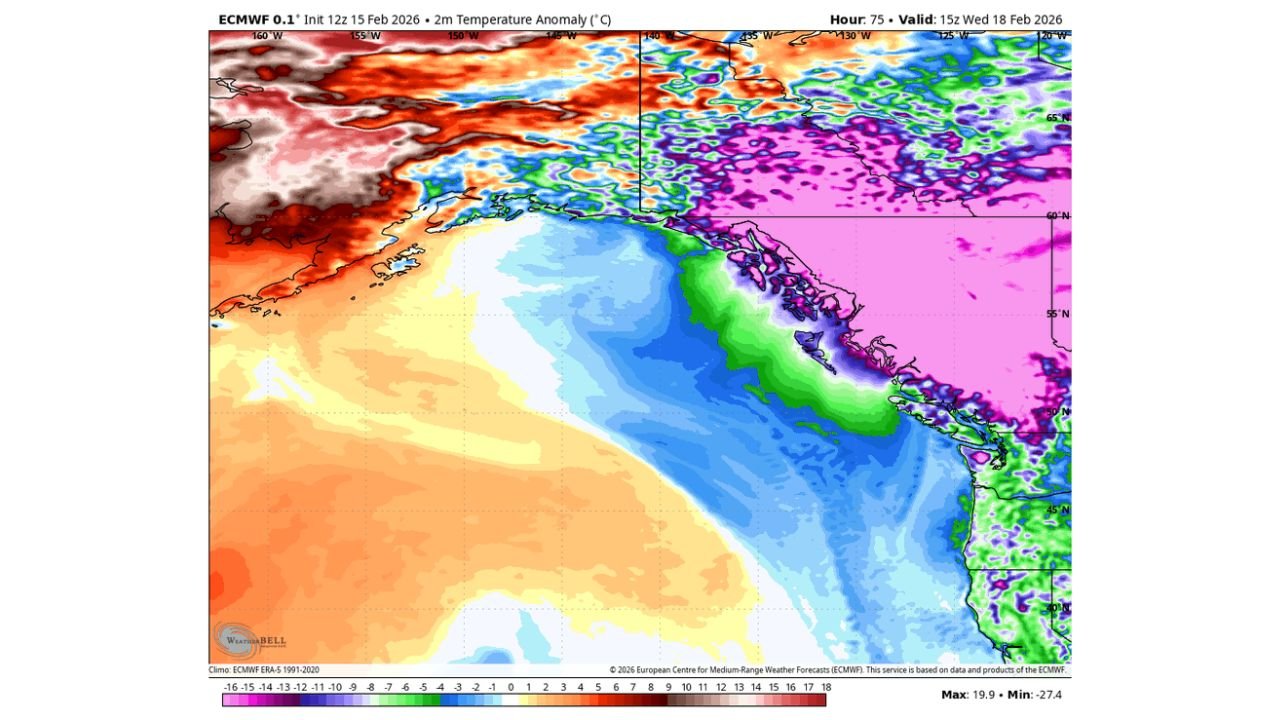
Model projections show significantly colder-than-normal air pooling across southwest British Columbia, with strong negative temperature anomalies extending south toward the U.S. border.
At the same time, 500 mb height maps indicate a pronounced ridge building west of Alaska and the Gulf of Alaska, allowing colder air to press southward along the eastern flank. This alignment creates a corridor where Arctic air can slide toward:
- Western Washington
- Northwestern Oregon
- The interior valleys near the Canadian border
However, the bulk of the deepest cold appears likely to remain centered over southwest British Columbia, meaning marginal temperature differences will determine whether lowland areas see rain or accumulating snow.
Why Timing Is Everything for Washington and Oregon
For cities like Seattle, Tacoma, Olympia, Portland, and Vancouver (WA), snow potential hinges on the precise interaction between incoming Pacific moisture and surface temperatures.
If precipitation arrives while:
- Surface temperatures are near or below freezing
- Cold air is sufficiently entrenched east of the Coast Range
- Offshore flow maintains low-level cooling
then snow could develop in portions of the lowlands.
If the cold air retreats even slightly, rain becomes the dominant outcome.
Meteorologists emphasize that mid-February events in the Pacific Northwest often require exact phasing. Even a one- or two-degree shift in temperature can dramatically change snow totals.
Best Snow Chance of the Season So Far
Forecasters note this may represent the best opportunity for measurable snow across parts of the Pacific Northwest all year. Previous systems have either lacked sufficient cold air or delivered precipitation too early.
This time, the ingredients include:
- Arctic air positioned just north of Washington
- A favorable upper-level pattern
- Incoming Pacific moisture
Still, confidence remains moderate rather than high. The cold air mass must hold firm across the region, and the precipitation shield must align correctly for significant snow accumulation.
What Residents Should Watch Next
The first potential snow window appears to begin as early as Wednesday, with additional updates expected after the next model runs.
Communities most likely to monitor closely include:
- Seattle and Everett
- Bellingham
- Tacoma
- Portland and surrounding metro areas
Higher elevations and foothills remain the most favored zones for accumulating snow. Lowland areas sit on the edge of the temperature gradient, where rain-to-snow transitions will be closely tracked.
If the cold air holds across western Washington and northwest Oregon, even a modest snow event could impact travel during the midweek period.
As Arctic air lingers over southwest British Columbia, the Pacific Northwest finds itself on the edge of a narrow winter opportunity. For continued updates on developing winter weather patterns across Washington, Oregon, and the broader United States, visit ChicagoMusicGuide.com.