
Pennsylvania, New Jersey, and Delaware Face Icy Thursday Morning Commute as Rain Flips to Brief Snow Behind Strong Cold Front
PENNSYLVANIA – A quick-hitting cold front moving through late Wednesday night into early Thursday could turn leftover rain into a brief rain/snow mix or a short burst of snow — and then freeze wet pavement fast as temperatures drop into the 20s, creating the risk of slick roads, icy sidewalks, and a tricky morning commute across parts of Pennsylvania, New Jersey, and Delaware.
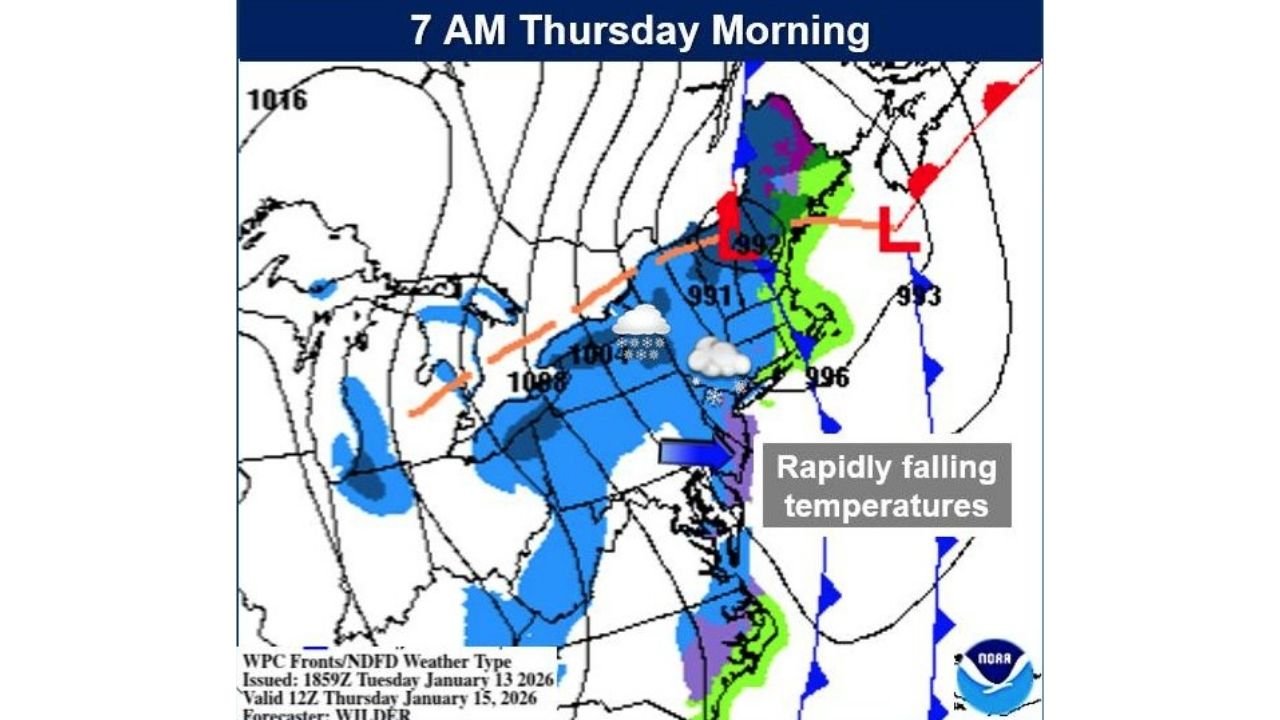
What the Latest Briefing Is Warning about
Forecast messaging for early Thursday is less about big snow totals and more about timing: rain or drizzle Wednesday evening, followed by a strong push of colder air overnight. As temperatures fall quickly, even minor slushy or wet spots can refreeze — especially on bridges, overpasses, shaded roads, and untreated sidewalks.
Key takeaways from the Thursday-morning setup include:
- Light rain Wednesday evening in the region
- Cold front overnight Wednesday night with temperatures dropping quickly
- Rain may mix with or briefly change to snow in the pre-dawn hours
- Precipitation may be ending around the Thursday morning commute window, but freezing temperatures could lock in slick conditions
- Snow accumulation looks minor, but ice risk could be higher than totals suggest
Where Slick Spots Could Be Most Likely
Because this is a “flash-freeze style” risk, the most common trouble zones are usually the same every time:
- Bridges and elevated ramps (they cool faster than regular pavement)
- Parking lots and sidewalks around schools, offices, and transit stops
- Back roads and neighborhood streets that don’t get treated as quickly
- Areas that get a late burst of precip right before temps plunge
In Pennsylvania specifically, additional snow and lake-effect/snow-squall potential can linger into Thursday, which can make conditions change quickly from one county to the next.
Timing Window to Watch
The highest-impact window appears to be late Wednesday night through early Thursday morning, when temps are falling and any leftover moisture can freeze. Even if steady precipitation is winding down, the freeze can arrive after the rain ends — which is why roads can look merely wet but behave like ice.
What This Could Mean for Live Music Plans and Venue Travel
ChicagoMusicGuide covers shows nationwide, and this is the kind of weather setup that can create real headaches for live events even without a major storm headline.
If you’ve got a concert, rehearsal, load-in, or late-night drive:
- Expect slower rideshares and longer drive times Thursday morning and early afternoon.
- Bands and crews doing early load-ins may want extra buffer for parking lots and dock areas that glaze over.
- If you’re traveling between cities (especially on highways with lots of bridges), plan for spotty slick stretches rather than one consistent road condition.
Smart, Practical Safety Moves for Thursday Morning
If your area turns slick, the basics matter more than ever:
- Leave early and assume ramps/bridges are icy first
- Walk like you’re on ice (short steps, hands free) on sidewalks and lots
- Keep an extra layer and charger handy in case of delays
- If you can, shift errands or nonessential travel until later Thursday, once temps stabilize and crews can treat trouble spots
Final Word
This isn’t shaping up as a blockbuster snowstorm for the Mid-Atlantic — but it’s the kind of cold-front switch that can create outsized impact during a busy commute when surfaces freeze quickly.
If you’re in Pennsylvania, New Jersey, or Delaware, keep an eye on local updates overnight Wednesday into early Thursday — and give yourself extra time if you’re heading to work, school, or a show.
What are you seeing in your area — rain, sleet, or a quick flip to snow? Share what conditions look like near you, and keep following ChicagoMusicGuide.com for weather-driven travel updates that can affect live music plans.