
Pennsylvania, New Jersey, New York, Maryland, Virginia, and Ohio Brace for End-of-Week Storm Bringing Heavy Rain, 55-MPH Winds, and Possible Severe Weather
PENNSYLVANIA — A strong storm system is setting up to impact large portions of the Central and Eastern United States by the end of this week, with the most significant effects expected across Pennsylvania, New Jersey, New York, Maryland, Virginia, and Ohio. Forecast models show a powerful warm-side system capable of producing widespread rainfall, damaging winds, and even pockets of severe weather in the South as the storm lifts north.
Storm System Strengthens as It Moves East
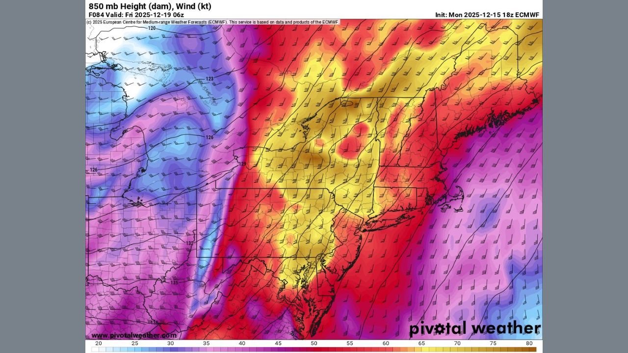
A rapidly developing low-pressure system will track through the central U.S. before pushing into the Mid-Atlantic and Northeast late Thursday into Friday. With the storm positioned on the warm side of the temperature gradient, meteorologists are monitoring a strong surge of moisture from the Gulf and intensifying wind fields at the mid and lower levels of the atmosphere.
850 mb wind projections show a corridor of strong winds sweeping through the Northeast, with values supportive of 40–55 mph surface wind gusts. These winds may be strong enough to cause tree damage and scattered power outages, particularly in higher elevations and exposed areas.
Heavy Rainfall Expected Across Multiple States
Forecast precipitation maps indicate a broad shield of rain moving through the Mid-Atlantic and Northeast as the storm matures. The system’s warm-sector positioning means temperatures will be well above freezing for most areas, reducing snow threats but increasing the risk of heavy rainfall and localized flooding.
Rainfall intensity is expected to peak late Thursday into early Friday, with the potential for widespread moderate to heavy rain across Pennsylvania, New Jersey, New York, Maryland, Virginia, and Ohio.
Damaging Winds Likely in the Northeast
Model guidance highlights a strong belt of mid-level winds directly overhead late Thursday night. When combined with a negatively tilted trough, this setup supports efficient downward transfer of momentum, allowing stronger wind gusts to mix to the surface.
The strongest winds are projected across:
- New Jersey
- New York
- Eastern Pennsylvania
- Maryland’s higher terrain
- Coastal areas from New Jersey into Long Island
Wind impacts may include scattered tree damage, isolated structural impacts, and travel disruptions, especially for high-profile vehicles.
Severe Weather Possibility in the South
Although the core headline impacts are focused on the Northeast and Mid-Atlantic, the southern U.S. may also face marginal severe weather as warm, moisture-rich air feeds into the developing storm. Thunderstorms forming ahead of the cold front could produce isolated damaging winds or a brief tornado risk before the system pushes northward.
Temperature Setup Favors a Rain-Dominant System
With the storm tracking on its warm side, the majority of precipitation will fall as rain across the impacted states. Cold air remains displaced far to the west during the event, limiting snow potential but allowing the storm to produce stronger wind fields and greater moisture transport.
What Residents Should Prepare For
Residents across the six core impacted states should be ready for:
- Heavy rainfall Thursday night into Friday
- Wind gusts up to 55 mph, especially in the Northeast
- Localized flooding, mainly in urban or low-lying areas
- Possible flight delays due to widespread wind impacts
- Minor power outages from downed tree limbs
Stay Updated Through the Week
Forecast confidence continues to increase as models come into tighter agreement, but small shifts in storm track or timing can still influence which areas experience the strongest winds or heaviest rain.
Chicagomusicguide.com will provide continuing updates as the storm evolves and new data becomes available.
If you’re in Pennsylvania, New Jersey, New York, Maryland, Virginia, or Ohio, stay alert for local advisories and prepare for rapidly changing weather conditions later this week.
Stay with Chicagomusicguide.com for the latest weather alerts, impact breakdowns, and updated forecast guidance.