
Pennsylvania, New York, New Jersey, and New England Face Multiple Late-December Winter Storm Threats With Snow, Ice, and Travel Disruptions
UNITED STATES — While much of the country experiences above-average temperatures and a continued winter thaw, the Northeast is shaping up for a far more active and volatile stretch of winter weather, with multiple storm systems expected to impact the region between Christmas and the final days of December.
Forecast guidance shows a light initial winter system arriving first, followed closely by a potentially more significant storm after Christmas that could bring widespread snow, ice, and mixed precipitation across parts of Pennsylvania, New York, New Jersey, Connecticut, Massachusetts, and surrounding areas.
First System Brings Light Snow and Wintry Mix Before Christmas
The first round of winter weather is expected to remain relatively modest, producing light snowfall and pockets of mixed precipitation, mainly across interior portions of the Northeast.
Model data indicates:
- Light snow accumulation, primarily inland
- Minor ice or sleet risk, especially during transition periods
- Limited coastal impacts, with precipitation likely changing to rain near the shoreline
While impacts should remain manageable, slick travel conditions are possible during peak commute periods, especially across elevated and interior locations.
Post-Christmas Storm Signals a More Significant Threat
Forecast confidence increases for a stronger winter system developing just after Christmas, driven by a more amplified upper-level pattern and strengthening surface low pressure.
Current projections suggest:
- Heavier snow bands developing across interior Pennsylvania, upstate New York, and interior New England
- Mixed precipitation and freezing rain potential across parts of New Jersey, southeastern Pennsylvania, and southern New England
- Higher-impact travel disruptions, particularly where snow and ice overlap
Ensemble snowfall guidance highlights several inches of snow possible across large portions of the Northeast, with localized higher totals where colder air remains locked in place.
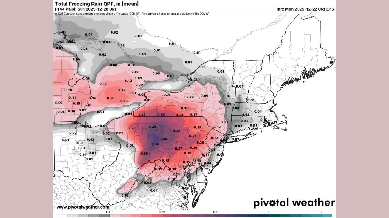
Freezing Rain Raises Ice Concerns in Transition Zones
One of the largest forecast challenges involves the placement of freezing rain, especially across regions where warmer air aloft overruns sub-freezing surface temperatures.
Areas of concern include:
- Interior New Jersey
- Eastern Pennsylvania
- Parts of southern New York and Connecticut
Even light ice accretion could result in dangerous road conditions, scattered power issues, and tree damage if freezing rain becomes more widespread.
Northeast Stands Apart From National Weather Pattern
This active Northeast pattern contrasts sharply with conditions across much of the central and southern United States, where milder air dominates and winter weather remains limited.
The repeated storm potential highlights a regional split, with the Northeast remaining vulnerable to persistent cold air intrusions that allow winter systems to remain impactful.
What to Watch Next
Forecast confidence will continue to improve over the coming days as models resolve:
- The exact storm track
- The rain-snow line
- The extent of ice accumulation
Residents across the Northeast should monitor updates closely, especially those with holiday travel plans in the days following Christmas.
Have you experienced early winter impacts where you live, or are you preparing for another round of snow and ice? Share your thoughts and stay weather-aware with ChicagoMusicGuide.com.